All Activity
- Past hour
-
Thought the same last night when it was 29°.
-
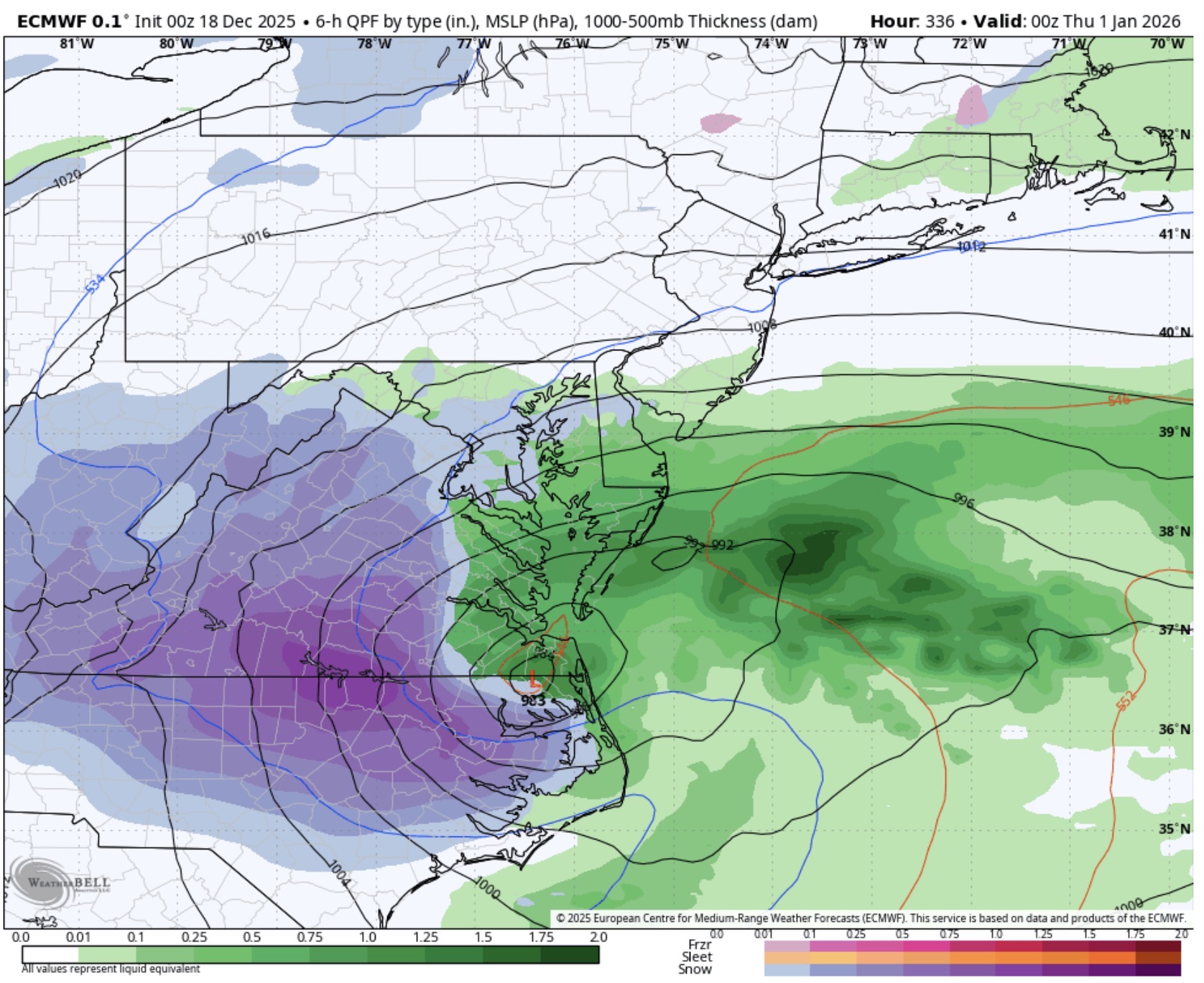
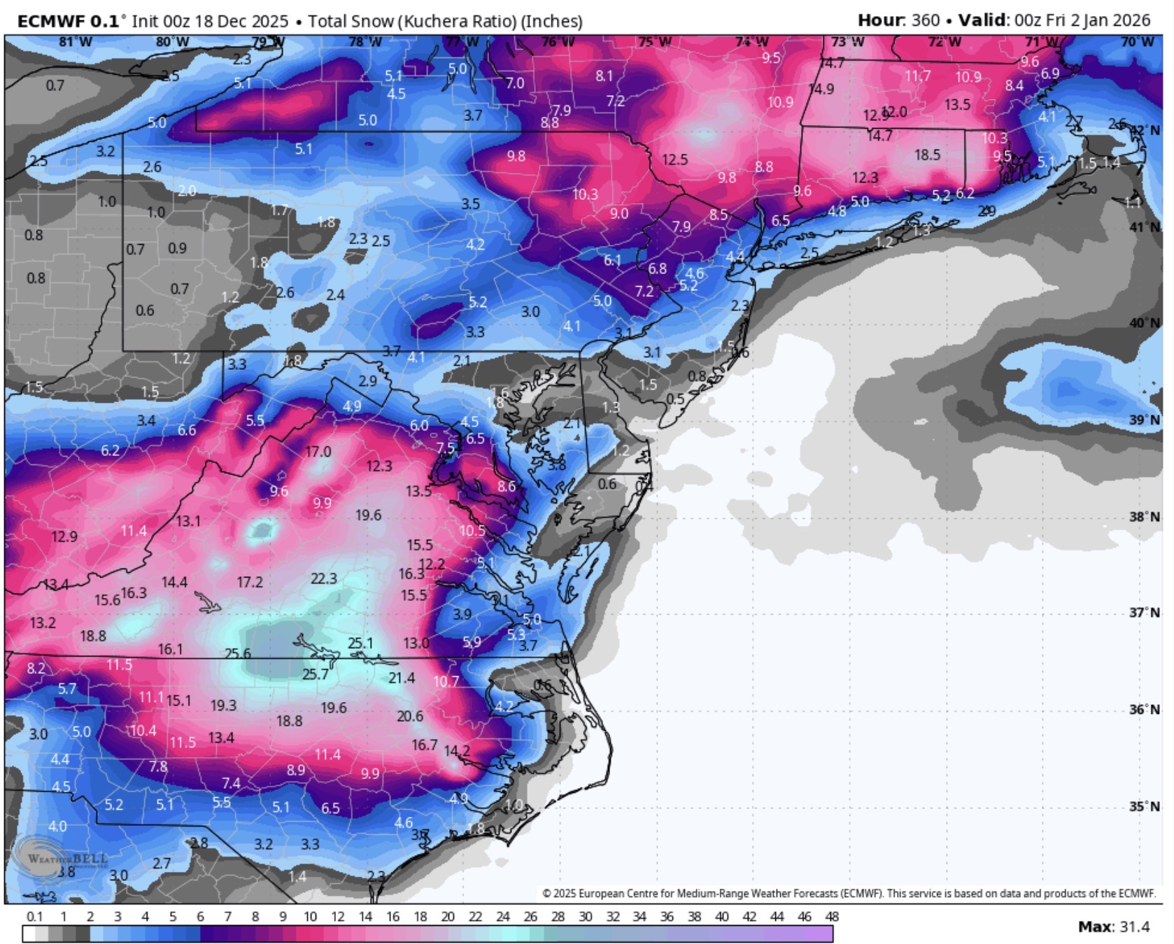
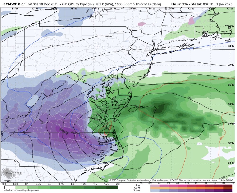
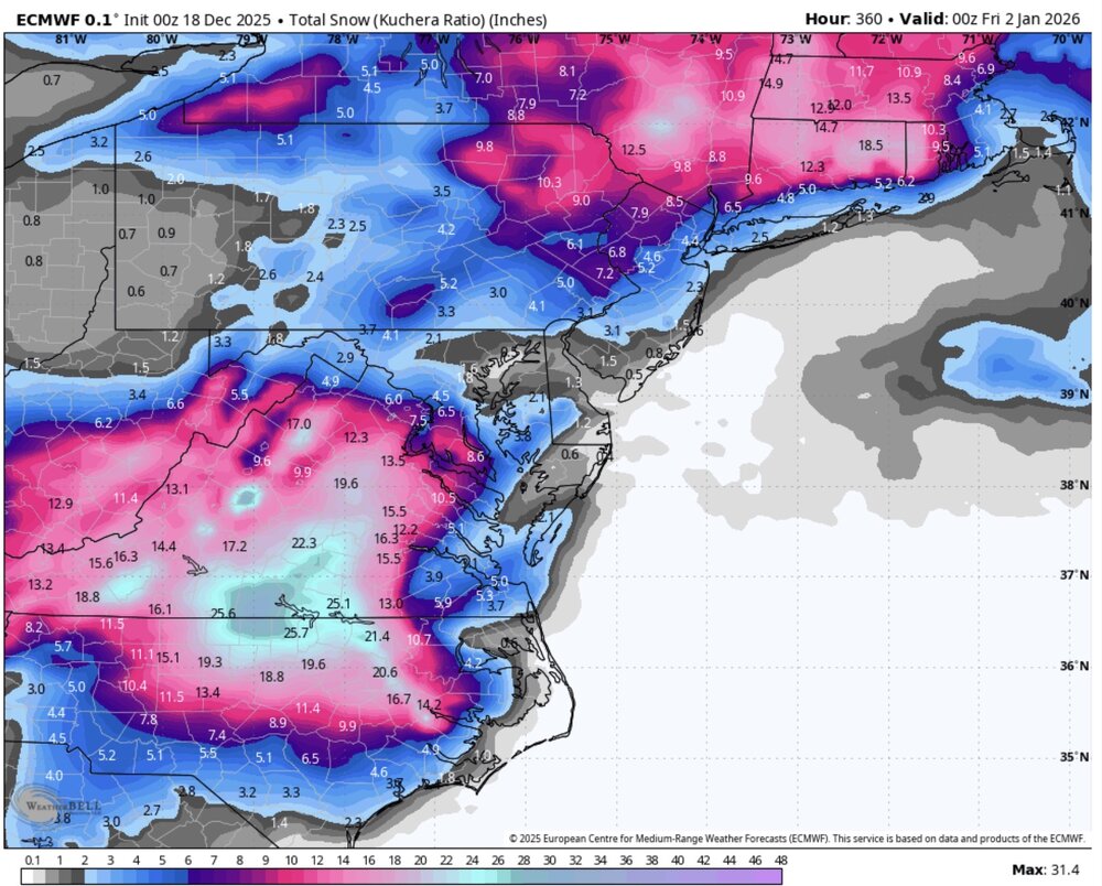
Not saying it's right but the 0z euro run would make many happy if it actually happened. Long duration event for sure.
.thumb.png.25a60fee094e013425776693802641d2.png)
-
I had a mental breakdown trying to understand the 0z Euro.
-
 No chance ORD finishes at -6. Something like -3 or so is more likely to be the final departure, maybe even -2 if we get a few super warm days.
 - Today
-

December 2025 Short/Medium Range Forecast Thread
Golf757075 replied to John1122's topic in Tennessee Valley
We haven't had a clipper in my area in a long time. Many years. -
I'd take an inch for Christmas. That would be cool!!
-
Yes I know. Was a poor attempt at humor lol
-
Would be real nice is this verified lol
-

December 2025 regional war/obs/disco thread
Torch Tiger replied to Torch Tiger's topic in New England
it's wild how warm 40's feel after the very cold month or so. -
I'll throw in for 2014-2015. 2010-2011 got the deepest, but 2015 was a close second. Plus we had drifts out back into April.
-

December 2025 Short/Medium Range Forecast Thread
John1122 replied to John1122's topic in Tennessee Valley
The ridge/trough orientation has just sucked for basically the entire forum. Especially the west side. It's been cold and mostly dry. We got clipped by a couple of clippers in the East. If the ridge had been oriented into a +PNA configuration, those clippers that buried the Midwest to Virginia would have been rolling across Tennessee. Northern Kentucky has gotten hit a lot. Louisville Kentucky already has about a foot in the first 15 days of met winter. With a +PNA that would have had that active northern stream, which is common in La Nina, over our forum area. -
Seeing as one of those January days had a low of -2...yep, sounds like it, lol Ya had only 4 days the entire month get to 40 degrees! Snowfall, on the other hand...was 8.5"...and we only measured a trace for the rest of the season. Oof...and seeing as the next year was a Niño, I wonder if 1976-77 was indeed a dying nina like this one seems to be. Rather paltry results in the snowfall department...and February torched as you'd expect, lol Anybody got what they indices (AO/NAO/PNA) were that winter?
-
Not enough blocking to get it done on the GFS. Its going to be tough to get the snow down this way for a couple weeks with that set up. but we know it rains on Christmas. As I say you can se your watch to it.
-
All of the mid-range guidance through day 7 has the thermal boundary too far northeast for us to have much of a shot at snow. Out to day 10 isn't much better. I hope it changes. It's a pretty ugly and repetitive looking longwave setup that would seem to favor New England for snow chances. But it doesn't exactly look warm either after Friday and the real cold is not too far off. But it's sure no fun looking at a huge stagnant ridge over the central US.
-
December 2025 Short/Medium Range Forecast Thread
Golf757075 replied to John1122's topic in Tennessee Valley
Here in jackson we haven't seen any snow or ice yet. I hated thar we had too much nw flow, but that's how it is sometimes. Hoping mother nature will throw a little winter weather sometime in the next few months -
Bring the rain. The drought is still pretty bad up here and we’ve had nothing soak in recently.
-
The gfs has done an outstanding job of sniffing out these storm cycles this year. When I’ve seen that darker blue precip shield sitting over the northern greens for 18-24 hours on a nw flow flow show up for 3-4 runs in a row, you can almost lock in an 18” upslope party every time so far this year. Even at a 3-4 day lead time. .
-
This is most helpful. Thanks for the clarification on what is considered a trace. It also confirms my suspected conversion factor was pretty much spot on: 5280 T = 1 in. .
-
Really looks like the -NAO wants to develop. But ideally we would want it to develop a bit more to the west and force some blocking across northern Canada and Greenland. But I believe east -NAO are good flow slowing storms down on the Atlantic side. That being said, you need help from the pacific as well but as long as Alaska stays cold and stormy, I’m not sure we’ll get much help. Looks like northeast will be the only place colder than average for the rest of the month. Been a torch across most of CONUS this entire week and will likely prevail into the new year. Places down south that we’re running 10 degrees below normal will finish around average from this torch. Warm Christmas for many, doesn’t look like that pattern will Let up through early January.
-
I grant that a few flakes may have been seen in the air on these dates, but nothing was measurable. If that counts as a trace, so be it. I need a skiff, or a dash, or a dusting, or a coating, or some other such word before I would call it even remotely measurable. .
-
it's 47F at my house on 43rd St. A station along the same cross street but at 47th St (and probably about 80-100' lower) is at 33F. The hill we are on basically slopes down to the Potomac River, so I assume that is something. Also the wind is very slight out of the east - about 1.5-2 blocks east is a much more commercial area along Wisconsin Ave.
-
Alot of fluffy snowstorms that winter
-

Central PA Winter 25/26 Discussion and Obs
canderson replied to MAG5035's topic in Upstate New York/Pennsylvania
Wind threats are a big things Friday. Possible even 60 mph winds for some of us. -
Low of 30, high of 66. Looks like the last of the cold for a bit.
-

E PA/NJ/DE Winter 2025-26 Obs/Discussion
Albedoman replied to LVblizzard's topic in Philadelphia Region
E PA/NJ/DE Autumn 2025 Obs/Discussion Albedoman replied to PhiEaglesfan712's topic in Philadelphia Region in October My forecast did suggest a slow start. Enjoy the fall weather while you can. Come january you will be wishing for temps above 45 . I expect more mix events than anything else in late nov into mid dec as the pattern sets up for january------- well I was pretty close. We will get 1-2 days this week above 45 degrees. Thank god it will melt the .50 in of snow equivalent liquid precip with the expected 1-2 inches of rain. That will help the drought somewhat for the stream base flows but the main problem is that the frost in the soil horizon is already pretty deep especially in the LV. The groundwater is likely not going to be recharged at all. You will see real muddy conditions in the yard for a few days as the topsoil is unfrozen, but then back into the deep freeze. I would love to see t storms Thursday night. The snow will quickly disappear with sublimation from fog and from the heavy rain. The down trees on Friday will be a huge problem from the winds as the soils around the tree roots will soften up just enough to be wind thrown before freezing. Main concern for me, if it rains hard enough Friday afternoon, the expected winds may not dry our the road surfaces from the excessive ponding and we will have flash freeze conditions Friday evening in many areas. Saturday morning may not be very nice around our region. Also, my utility bill is doubled from last year according to my usage and I still have have a 15 days to go. Going to be many homeowners wishing they had not spent so much on Christmas gifts come mid January when they get their utility bill. This chart says it all just posted by Mt Holly.


.png.66ab42f65e1659fd73fd0199db3ccc3d.png)