All Activity
- Past hour
-
That’s fine. I can’t afford playoff tickets anyway.
-
36.2, consistent with the other PWS in the area. A few of the colder local spots got down to 33/34, but nowhere closeby got to 32
-
PWS nearby has 32. May be a little low, surrounding stations have 36-38.
-
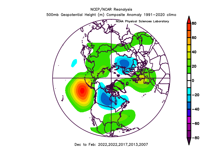
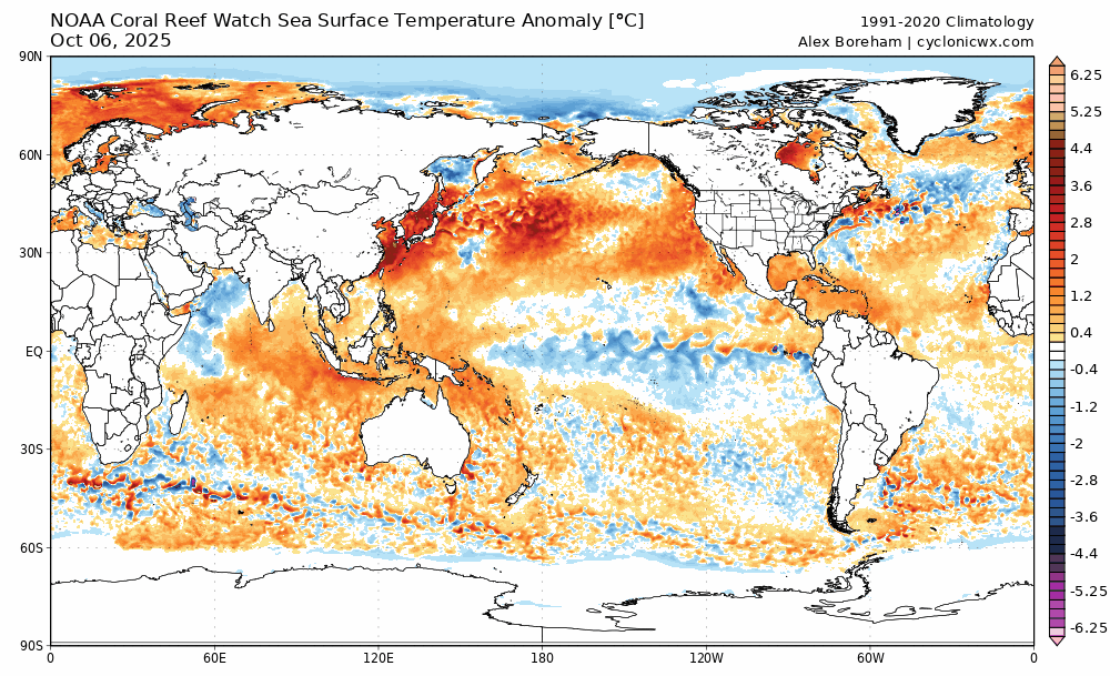
We have reached the point where people using 2013 as an SST analog (SST analog) have an issue. Not commenting on any other factors being used as an analog to that year, just SSTs. But as it stands now, we are not even in the ballpark of going into a Victoria mode PDO, not even close, whereas we were into a Victoria mode PDO by the beginning of November back in 2013….
-
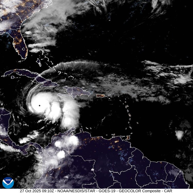
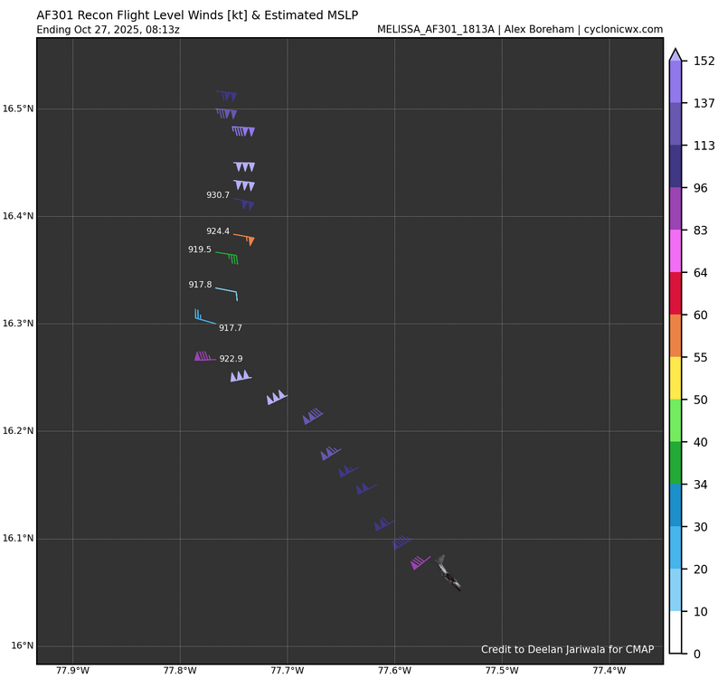
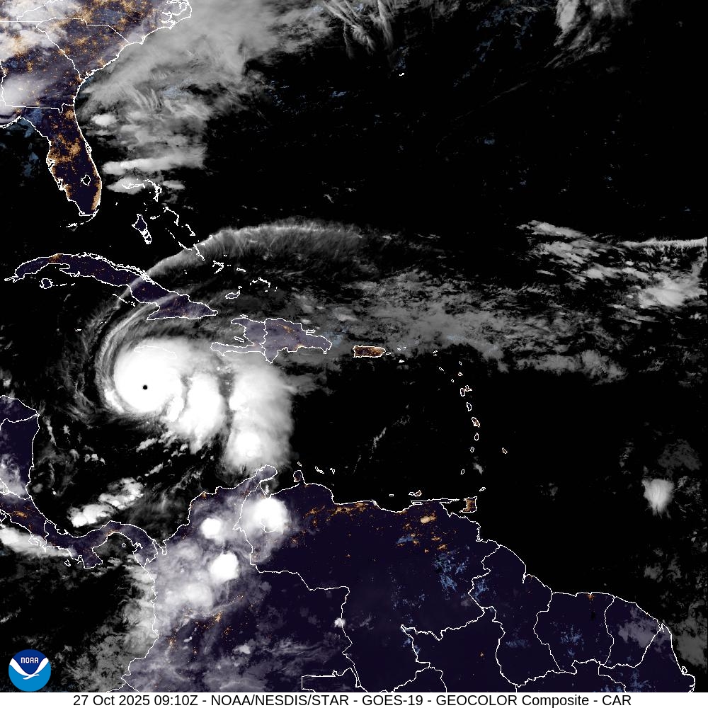
Most recent long-range radar scan. The eyewall remains uniform and intense. It does appear a concentric outer band is trying to form around the periphery of the eyewall. We still have 24-28 hours until landfall. That is plenty of time for an EWRC to begin. The forecast is for Melissa to be a Category 5 at landfall, but internal structural changes could still bring down that intensity to Category 4. But again, that is not necessarily a good thing for the island, as the windfield would expand east towards higher populated areas. I actually do think the intensity will fluctuate down by landfall as I still think outer banding will get its act together and weaken the small eye by tonight. It is very difficult for a high-end TC like this to maintain that intensity for that many hours without fluctuations. Time will tell.
-
A raw morning out with a low of 39 and rain knocking on the door.
-
Another hard freeze here currently 27
-
I downloaded these this morning.
.thumb.jpg.f667505794bbb478fdb726c9ab7250d4.jpg)
-
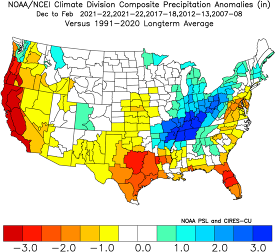
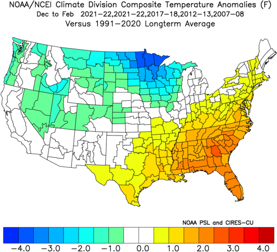
Here's my winter outlook. (more of the same...)
-
My outlook. May do Edition 2 if things change in November. Or maybe not.
- Today
-
Not a whole lot has changed this month, so I decided to go ahead and issue my outlook for this winter. I'll keep it brief and simple: Overall winter feel: Meh, but not full-on blowtorch. Cool ENSO/weak basin-wide Nina coupled with -QBO Strong -PDO trying to turn the corner but not quite getting there -IOD bracketing MJO activity to phases 3-7 with limited 8-1-2 activity More weak troughing east of Japan pushing N. Pac High east into GOA (this helps us) Mostly -PNA, but with some +PNA episodes with plenty of Canadian cold air to tap into Weakly +NAO on the means with at least 2 or 3 bonafide -AO/-NAO blocking episodes Snowfall guess: 9-11" for the forum, maybe a few inches more for CAPE and northward of him Predicted mean DJF NH Pattern based on listed analogs (2021-22 weighted twice): SST changes last 15 days: Extrapolating cool SST/troughing east of Japan while warm blob pushes to the east. Cool area in GOA probably will not last. Atlantic pattern seems neutral towards NAO bias, but increased risk of SE ridge linkage with -NAO. Temp and Precip DJF Maps: Warmer and drier across the SE. Mild East Coast, but not torchy, plenty of cold air to tap into, but timing and SE ridge linkage will be an issue to contend with at times. Rockies, Upper MW, Great Lakes, and non-coastal SNE and all of NNE are poised to have a great winter.
-
Third cat 5 of the season. Absolutely insane.
-
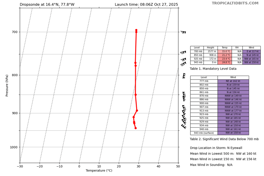
5:00 AM EDT Mon Oct 27 Location: 16.4°N 77.8°W Moving: W at 3 mph Min pressure: 917 mb Max sustained: 160 mph .
-
5:00 AM EDT Mon Oct 27 Location: 16.4°N 77.8°W Moving: W at 3 mph Min pressure: 917 mb Max sustained: 160 mph .
-

Spooky Season (October Disco Thread)
Damage In Tolland replied to Prismshine Productions's topic in New England
The screamer is Thursday / Thursday night with dry slot Friday. Helloween is saved for Scooter -
those winds were not measured at the surface..
-

Spooky Season (October Disco Thread)
ineedsnow replied to Prismshine Productions's topic in New England
Melissa a cat 5 now.. what a beast -
Officially a Cat 5
-
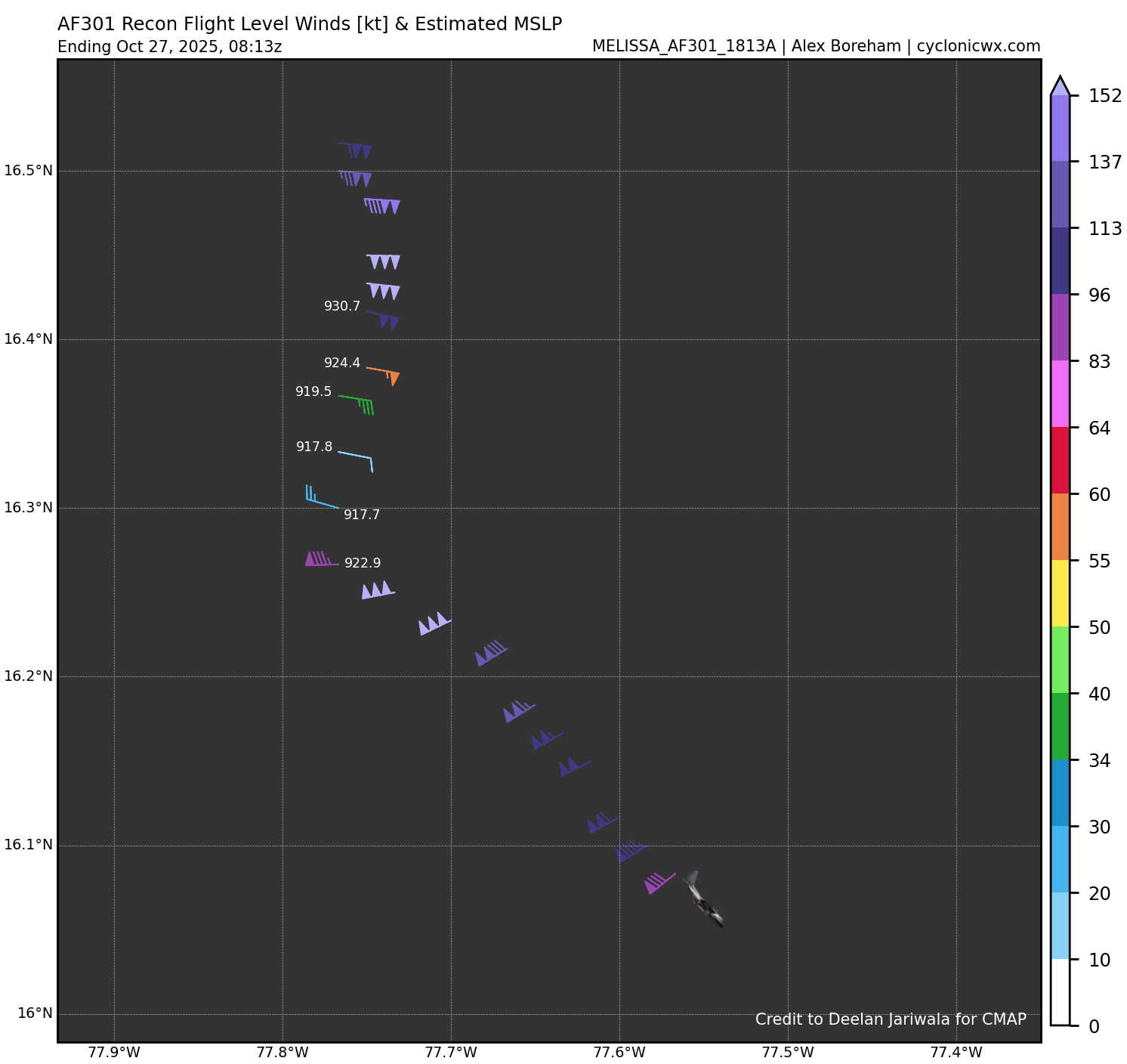
Recon measured 158kts in the north eyewall at the surface. This equates to 180-185mph range for surface winds.
-

Spooky Season (October Disco Thread)
Modfan2 replied to Prismshine Productions's topic in New England
Down to 29F so far here this morning, pretty chilly. -
Since we are almost into November, I figured I would go ahead and start this new thread for the 2025-2026 winter season. Current ENSO indicates a weak La Nina to Neutral type winter. Snow and cold forecasts could go either way. Feel free to share your thoughts and forecasts for this upcoming winter.
-
917mb in N/NE quad. Along with the 140kts they measured earlier in the NE quad, Melissa will now be upgraded to a Category 5. Either we get a special advisory or they wait for 5am.
-
Looks like we are around 30 hours from landfall give or take a few depending on timing of the trough influenced deep layer southerly flow. We should start to see northward motion begin by midday or noon'ish. Timing on this is critical for the eventual landfall point.
-
The view of a peaceful starry night, inside the maelstrom of Melissa.
-
Yeah recon shows no evidence of weakening. Probably the opposite at this hour. I mean, expect another 2-4mb drop on the next pass. The ERC will happen eventually, but it’s not right now.


.jpg.b6b906d42ee52f748882238f5ba4cfda.jpg)