All Activity
- Past hour
-
Just went under the freezing mark this morning at 31.8 degrees, still breezy, WNW at 10 gusting to 21 now with partly cloudy skies.
-

November 2025 general discussions and probable topic derailings ...
powderfreak replied to Typhoon Tip's topic in New England
We just don’t know. Could be lower. -
Happy turkey day, y’all. Be safe and enjoy time with friends and family
-

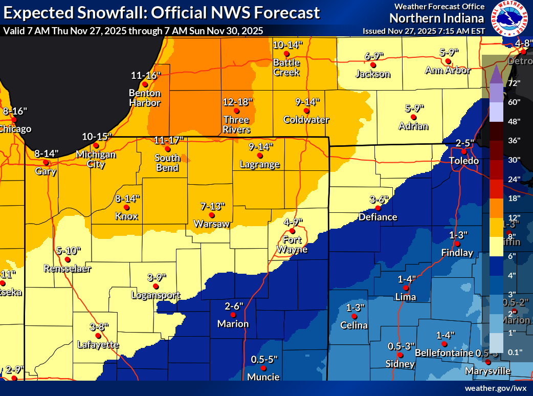
Nov 28-30th Post Turkey Day Wintry Potential
sbnwx85 replied to Chicago Storm's topic in Lakes/Ohio Valley
The high end of the range is way overdone. 11” here by Sunday morning is plausible if things go well. For the storm itself, things have been looking good for 6-10” for a while. NAM is juiced up but that’s typical at this point. -
Happy Thanksgiving to you and your families everyone.
-

Best Mid-Atlantic winter storm of the last 50 years
clskinsfan replied to PrinceFrederickWx's topic in Mid Atlantic
For MBY it's 2016. And it isnt close. I will never live to see 40 inches from a single storm again. -

December 2025 regional war/obs/disco thread
moneypitmike replied to Torch Tiger's topic in New England
Exactly where we want it now That's my story, and I'm sticking to it. -
Not gonna sleep on the chance Saturday night either. Chance for a lot of us to see our first flakes of the season.
-

Nov 28-30th Post Turkey Day Wintry Potential
A-L-E-K replied to Chicago Storm's topic in Lakes/Ohio Valley
Should be a fine lil event with bonus points for the holiday weekend Saturday timing. I think those with big dog on the brain might be bummed. -

Nov 28-30th Post Turkey Day Wintry Potential
King James replied to Chicago Storm's topic in Lakes/Ohio Valley
Overdone? Still seems to be two camps with this one. Trends to me seem to indicate a pretty big event here but LOT and some posters here (guessing leaning into climo) are hedging their bet some. -

December 2025 regional war/obs/disco thread
Kitz Craver replied to Torch Tiger's topic in New England
Where is Runaway? Everything ok with him? -

December 2025 regional war/obs/disco thread
WinterWolf replied to Torch Tiger's topic in New England
I think you’re thinking of SWFE’s…those tend to come in quicker. As depicted, this is a coastal now, so I don’t know if the same thing applies? -
Favorable snow pattern for midwest/lakes and C/N New England. Lean towards cooler than normal further south but likely too warm for snow due to unfavorable storm track.
-
Nov 28-30th Post Turkey Day Wintry Potential
sbnwx85 replied to Chicago Storm's topic in Lakes/Ohio Valley
This includes today’s lake effect but c’mon now.

-
December 2025 regional war/obs/disco thread
WinterWolf replied to Torch Tiger's topic in New England
If it pans out, I like the idea that it starts during the day(visual in daylight is always nice), then goes into the night. But beggars can’t be choosers…. -
That run of the euro wasn’t that far off from hitting decent in most areas dc north. Hold that high a little longer or speed this thing up and its game time.
-
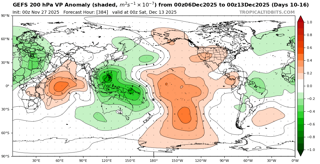
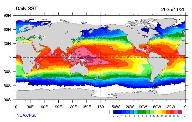
You can see how the long range models continue to underestimate the forcing near the Maritime Continent with the record warm pool there. So it interferes with the progression to a true MJO 8 500 mb and storm track pattern with the weaker Pacific Jet. This is why the RMM charts appear to show a slowdown or loop near the 7-8 border and lowering amplitude toward the circle following the higher amplitude 7. New run Old run WPAC warm pool with expansive area of +28C to +30C SSTs


-
Well based on those stats that @psuhoffmanshared last year, all of us well south of the M-D line should be happy if you get snow while we shovel cold rain because it means good things for the rest of the winter
-

December 2025 regional war/obs/disco thread
HoarfrostHubb replied to Torch Tiger's topic in New England
Might start a bit later than that. I’m thinking noon/ish for a lot of folks (as currently modeled). But nobody knows… -
Ya seems these come in a bit earlier
-

Nov 28-30th Post Turkey Day Wintry Potential
Baum replied to Chicago Storm's topic in Lakes/Ohio Valley
I’d agree. If I could pull 6” on Thanksgiving Weekend would pretty much be a lifetimer for me. Note any other Chicago event you see for Turkey weekend turned to slop post event. That will not be the case this time. Real cold to follow allowing the snow to stick around. Big difference -
December 2025 regional war/obs/disco thread
Kitz Craver replied to Torch Tiger's topic in New England
Happy Thanksgiving all! What’s better than tracking a storm to kick off the holiday season, hope we can all cash in to some degree! -
Last nights Euro was the warmest run in a while and had some SE Ridge at times. More volatility eh?
-

December 2025 regional war/obs/disco thread
Damage In Tolland replied to Torch Tiger's topic in New England
The storm is Tuesday . Comes in predawn . Today is 5 days -
@40/70 Benchmark As you and @Bluewave suspected…..