All Activity
- Past hour
-
Wow RDM. Not sure what to say to this. Makes Atlantic Canada look like the DMV in May.
-
-

Pittsburgh/Western PA WINTER ‘25/‘26
colonel717 replied to Burghblizz's topic in Upstate New York/Pennsylvania
I would love to visit him. My luck is If i drove there and the rug gets pulled. Looks interesting late week here. Watch that one turn I to a coastal too... -
So sorry.
-
This isn't a rain snow line storm. It's where's the phase and mid level low tracks/how soon do they close off. And so far they're all trending more favorable every run.
-

“Cory’s in NYC! Let’s HECS!” Feb. 22-24 Disco
Prismshine Productions replied to TheSnowman's topic in New England
GEM and Ukie both came NW Sent from my SM-S166V using Tapatalk -
whats going on here ?
-

“Cory’s in NYC! Let’s HECS!” Feb. 22-24 Disco
Typhoon Tip replied to TheSnowman's topic in New England
He’s probably waiting on NWS to pull their trigger -
Measured 4.5" about 30 mins ago. Another round now and more in the pipeline. 33/32
-
Totally makes sense. It is a positive step regardless.
-
His plane got lost at sea. Lol
-
I think the winds will break up the dendrites and slightly temper accumulations but I don't think this is going to be a wet paste type of snow that clings to everything such that it will bring down trees and power lines. Not going to be champagne powder either.
-
Thanks
-
Ukie backs even further west again, precip shield looks weird and again I'd argue it could/should be better with where the h5 and H7 lows stack
-
Strong 2011 vibes from when I lived in ChesCo. I don't think we'll see the brunt of it up here in Berks, but you guys closer to I-95 may be in for a treat if this all verifies.
-

Pittsburgh/Western PA WINTER ‘25/‘26
Rd9108 replied to Burghblizz's topic in Upstate New York/Pennsylvania
Still a little time for a last minute trend but anything more is out of the question. -
Anyone worried about rain should see how that rain/snow line crashes rapidly even as the low barely moves. This storm is very dynamic!
-
I can't remember the last time we saw the modeling break to the GFS like this. Absolutely amazing to see.
-

“Cory’s in NYC! Let’s HECS!” Feb. 22-24 Disco
Baroclinic Zone replied to TheSnowman's topic in New England
Keep in mind places north and west of BOS-BDL line are seeing precip. Down SE MA way we’re pretty much done -
“Cory’s in NYC! Let’s HECS!” Feb. 22-24 Disco
Typhoon Tip replied to TheSnowman's topic in New England
Yeah, I don’t think the northwest trend is really done until we can verify that across two complete cycles Still plenty of time folks -
I ignore the UKIE for thermals…well actually I ignore the UKIE in most regards, but good to see it move to the GFS.
-
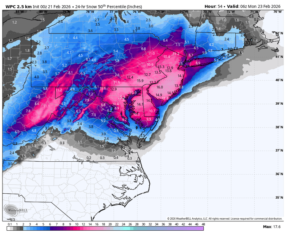
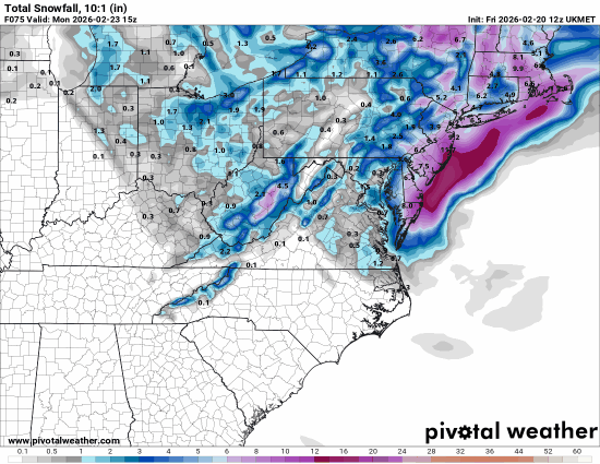
2/21 00z UKMET Total QPF 2/22 - 2/23 - 24 (expected more) Snow 10:1
-
-
His reasoning is mainly the positive NAO. He just doesn't think the storm is ever going to tilt negative, which by now its conceivable it almost certainly will. He just sees a progressive and positive orientation.
-
Yeah I edited i thought east was west lol