All Activity
- Past hour
-
Gunna suck pretty bad for all of our inner child hopes for a classic white Christmas hopes. Praying things turn around Christmas week.
-

December 2025 regional war/obs/disco thread
Snowcrazed71 replied to Torch Tiger's topic in New England
It literally can go either way, 50/50 as far as Christmas and a warm up or staying chilly. I think staying on focus for the possible snow event this Sunday makes more sense. We can't even figure out what's going to happen in 4 days let alone 2 weeks -
Snow and Nina correlations are abysmal and you're not bound by prior analogs for it.
-
4.1” at MSP Scattered snow showers and another clipper tonight.
-
That's why we will warm up a bit.
-

December 2025 regional war/obs/disco thread
40/70 Benchmark replied to Torch Tiger's topic in New England
Yea, if the nascent mid level lows are far enough south, sure....just going by the position on those ensemble products neat the BM. I would have to assume the mid level lows would be far enough north to impact most of the area. -

December 2025 regional war/obs/disco thread
HoarfrostHubb replied to Torch Tiger's topic in New England
Rain train on the GFS OP -
Everyone?
-
There is still a standing wave at the MC (phases 4-6) until that changes, this is going to keep happening
-

2025-2026 ENSO
brooklynwx99 replied to 40/70 Benchmark's topic in Weather Forecasting and Discussion
not surprising that we're seeing a warmer interlude with some -VP contaminating things in the IO and western MC. this quickly changes back to strong WHEM forcing in late Dec, likely signaling a flip back to a more favorable pattern after Christmas and into the New Year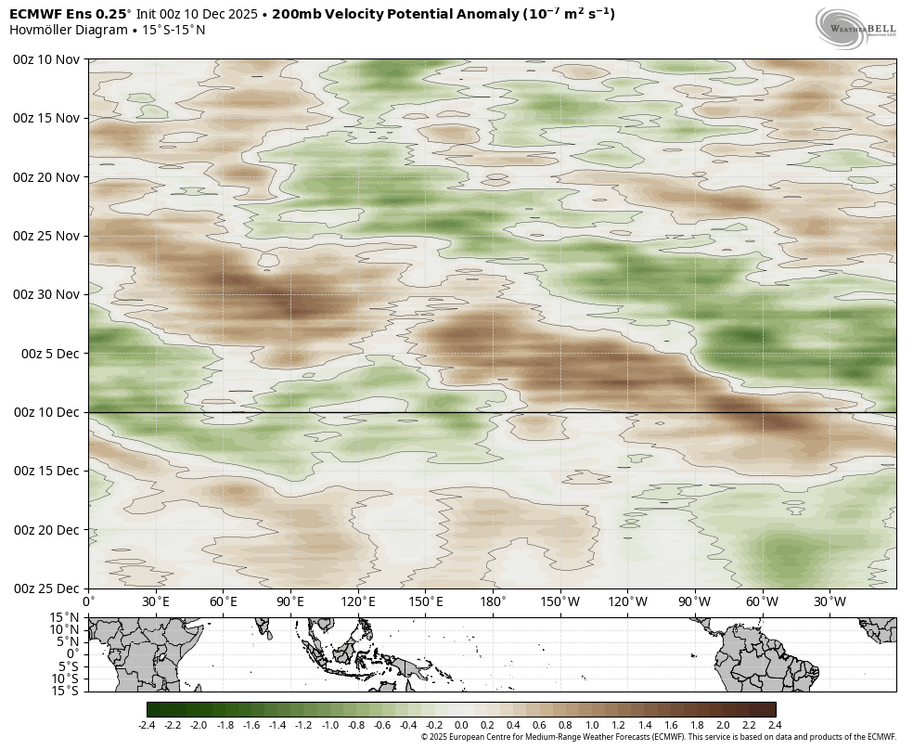
-
Yes
-
December 2025 regional war/obs/disco thread
HoarfrostHubb replied to Torch Tiger's topic in New England
Should I install? -
6z GFS brings the 591dm ridge back.
-

Winter 2025-26 Short Range Discussion
Cary67 replied to SchaumburgStormer's topic in Lakes/Ohio Valley
All good things... -
Doesn't the GFS even show snow south of the city?
-
Every single IOD event (negative or positive) in history has weakened in December. It peaks in October/November then weakens in December. This is perfectly normal climo, no matter how strong the event peaks, every one of them has done this
-

December 2025 Short/Medium Range Forecast Thread
AMZ8990 replied to John1122's topic in Tennessee Valley
URGENT - WINTER WEATHER MESSAGE National Weather Service Charleston WV 1205 AM EST Wed Dec 10 2025 WVZ522-523-526-101315- /O.CON.KRLX.BZ.W.0001.251210T1500Z-251211T1500Z/ Southeast Webster-Northwest Pocahontas-Southeast Randolph- Including the cities of Harman and Snowshoe 1205 AM EST Wed Dec 10 2025 ...BLIZZARD WARNING REMAINS IN EFFECT FROM 10 AM WEDNESDAY TO 10 AM EST THURSDAY... * WHAT...Blizzard conditions expected. Total snow accumulations between 4 and 8 inches with locally higher amounts likely. Winds gusting as high as 45 mph. * WHERE...Northwest Pocahontas, Southeast Randolph, and Southeast Webster Counties. * WHEN...From 10 AM Wednesday to 10 AM EST Thursday. * IMPACTS...Travel could be very difficult. Widespread blowing snow could significantly reduce visibility. The hazardous conditions could impact the Wednesday evening and Thursday morning commutes. Strong winds could cause tree damage. * ADDITIONAL DETAILS...An initial band of snow will move in late this morning into the early afternoon, creating blizzard conditions. There could be a break from blizzard conditions in the afternoon, before blizzard conditions set back in during the late afternoon or early evening hours. PRECAUTIONARY/PREPAREDNESS ACTIONS... Travel should be restricted to emergencies only. If you must travel, have a winter survival kit with you. If you get stranded, stay with your vehicle. The latest road conditions for the state you are calling from can be obtained by calling 5 1 1 or by accessing the online traffic and roadway portal for your state. Additional information can be found at https://www.weather.gov/rlx as well as on our X and Facebook pages. && -
So the 00z euro was weaker (a little more open) with the SPV and further south with it than other runs. To my eyes, it tries to squash the shortwave and it ends up more of an elongated, sheared mess as it reaches the northeast. The better runs have kept the SPV a hair further north with a few closed contours and that shortwave dives under more intact, they do a little fuji, and then we get the good punch of dPVA curling near SNE as the SPV merges in behind it. As Ray said, this is all happening at high speed. But there’s a lot going on in the arctic with these pieces over the next 24hrs before they start to separate themselves and become more clean cut. People get pissed at the models, but it doesn’t take much of a change upstream 96hrs out to throw things out of whack.
-
Yeah looking very grinchy this year.
-
Wish I could believe it
-
lol are we really just tossing the most skilled guidance right now in favor of the GFS and CMC? if the euro showed rain and the GFS showed snow i'm sure that wouldn't happen
-
We just have to be grateful for any snow we can get when the Pacific Jet is this extreme.
-
6z Eps
.thumb.png.289ee9d4463d1008e978168b02159e87.png)
-
JB agrees with Roundy about a brief break in the cold.
-
The question for me is would it be worthwhile to come up very early Thursday morning for this upslope event? The one drawback is the strong wind gusts.


.png.da01ef1e71a912569246cca5aaa79531.png)