All Activity
- Past hour
-
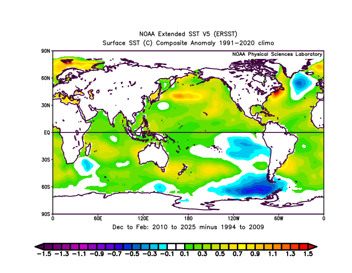
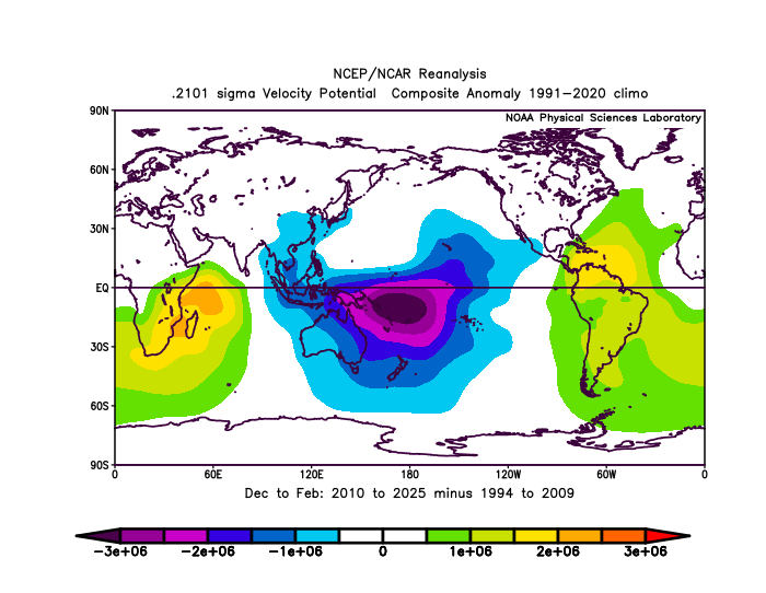
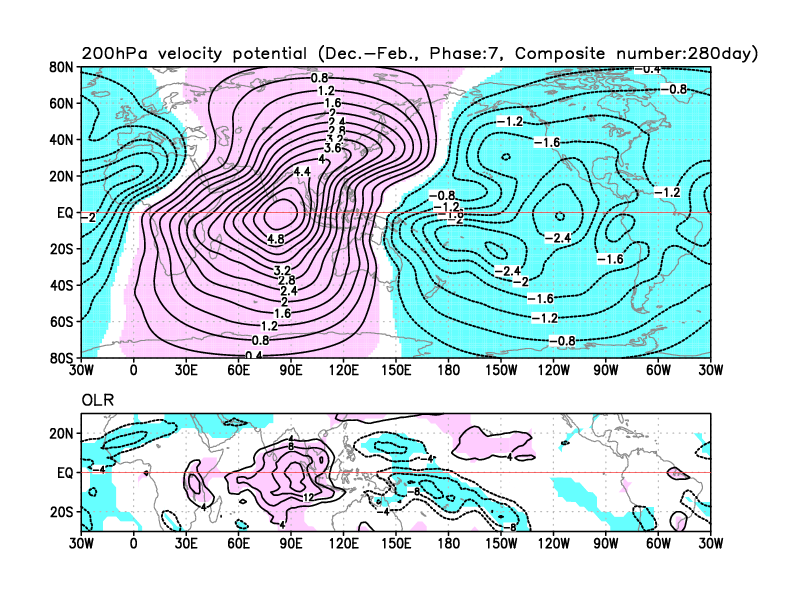
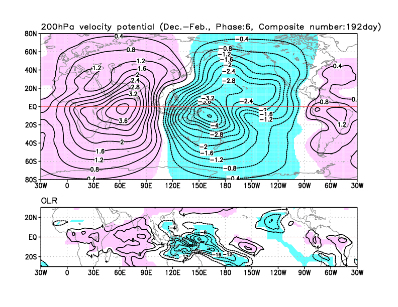
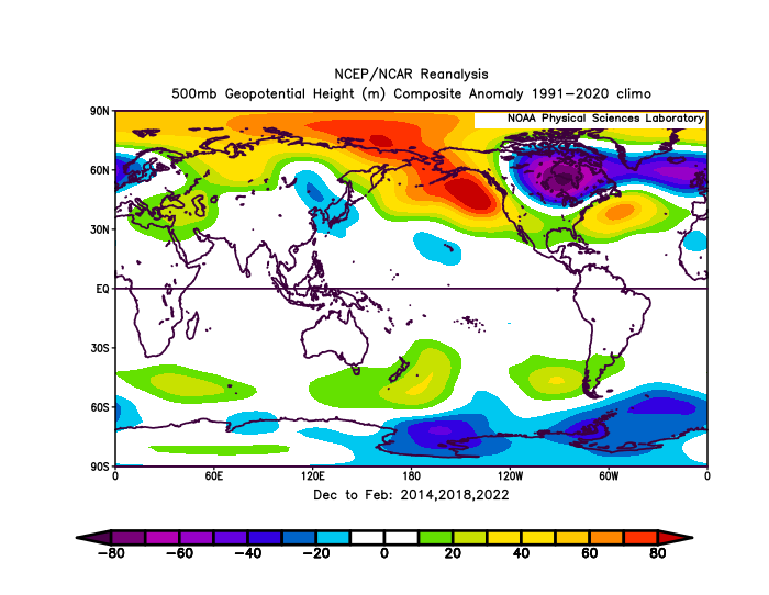
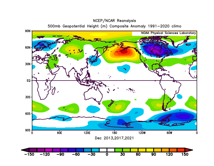
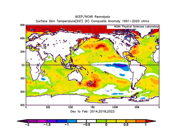
Yeah, this is what I have been discussing. The rapid warming of the WPAC tropical SSTs near the near the Maritime Continent has been stalling the MJO in the warmer storm track and background temperature phases. So the MJO progression tends to linger longer in the 4-7 phases and spend less time in phase 8. This is why January 2022 was the last time that the RMM and VP anomaly charts were both solidly in Phase 8. From March 2022 through the winter of 2024-2025 the few MJO 8s per the RMM charts had lingering forcing in phase 5-7 regions. So we didn’t fully realize the MJO 8 pattern which we last had in January 2022. Many times the models try to rush the progression through phase 8 and it gets delayed and or weakened the closer in time we get to the forecast period. This is what is shown when we subtract the last 15 years from the previous 15 years. You can see the stronger forcing closer to phases 6-7 where the warmest SSTs on earth near +30C are found during the winter.
-
Amazing job! Thanks guys .
-
yes, it's real. It's a long range forecast that's been somewhat consistent with the GFS and ECMWF the last couple of days, I think
-
Yeah clouds again hanging on and pushing in
-

2025-2026 ENSO
40/70 Benchmark replied to 40/70 Benchmark's topic in Weather Forecasting and Discussion
I have a learned a ton from you postings. -
2025-2026 ENSO
so_whats_happening replied to 40/70 Benchmark's topic in Weather Forecasting and Discussion
Honestly I wish it could be as simple as saying we are going into a phase 8 pattern thus it should look like this. The issue going on is we are still in a Nina like background state but we are getting intrusions of Nino like features popping up. I honestly never thought this setup would work out as well as it is. Lets see how things continue -
I think you will. 12z models are showing a better press with the storms ahead.
-

2025-2026 ENSO
40/70 Benchmark replied to 40/70 Benchmark's topic in Weather Forecasting and Discussion
I'll bet you $100 I have a plowable event of 3" or greater by the end of the second week of December (14th). -

November 2025 general discussions and probable topic derailings ...
H2Otown_WX replied to Typhoon Tip's topic in New England
When the pattern comes together "I know the pieces fit" -
Well, we are back to zero because the Euro just came in way different at the end of the week. Last night the Euro looked like the GFS, but now it has suddenly pulled all the energy back into the western US and pulls a bunch of warm air up into Iowa so we get rain.
-
Torching here. Sunny and the temp has jumped to 59 after a morning low of 29. West wind gusting to 30.
-
So much for that mostly sunny forecast!
-
One thing that I don't like is the lack of cold and snowstorms over CONUS thus far. I remember mentioning this in December 2023 and December 2024. Even years that were not good for us (2019,2020,2023) still had way more snowstorms and cold thus far. In many years, the snowstorms began as early as October, but even if it didn't begin in October, it began in November, and there would be a few large ones and several smaller ones as we neared December. Fall 2023, Fall 2024, and Fall 2025 have been virtually devoid of snow across CONUS outside of a few mountain ranges in New England and parts of the Great Lakes (and even then, that's been pretty muted). Part of this is likely due to the warmth in Canada, as that moderates temps across the northern tier, making most of their precipitation rain thus far. Ideally, you like to see a quick start to the season in October or November across the Plains and Upper Midwest, but like Fall 2023 and Fall 2024, that has been almost entirely absent this season. Snow begets snow, and cold begets cold. When that is absent from nearly the entirety of the US, with December right around the corner, that's never a good sign imo. I raised these points last November and December as well.
-
Clouds seem to be the only thing preventing our afternoon highs from torching.
-
Just got through a cloud spoke here from the typical GL low, but it's gotten sunny again. The afternoon is looking prime: https://www.star.nesdis.noaa.gov/GOES/sector_band.php?sat=G16§or=ne&band=02&length=12 OTOH, New York State is cloudy...because it usually is. They're definitely on the wrong side of the Great Lakes with the exception of LES which would probably get played out after a while.
-
We shall see if he gets some playing time. That's exactly what he needs. Clearly has more talent than the 2 turds currently playing OG.
- Today
-
Another day of clouds here. The forecast was for mostly sunny. But, so far 90 % of this day has been mostly cloudy. A theme the last 10 months.
-
having to drive back north on sunday, I'm watching this closely, but am honestly more just excited for something to track
-
As I said, we will also want to see GEFS as comparison, not just the EPS
-
Look who keeps giving me weenies
-

November 2025 general discussions and probable topic derailings ...
das replied to Typhoon Tip's topic in New England
Steady snow here in Charlotte, just south of Burlington. There’s about a half an inch on the ground. Temp was 35°F at onset with a dewpoint of 23°F. We have bottomed out at 31° here in the snow as the column saturated.





.thumb.jpg.ad3a2e31d30aff035044689b311a0540.jpg)

