All Activity
- Past hour
-
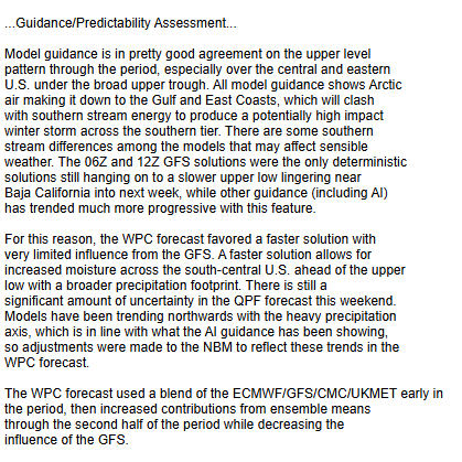
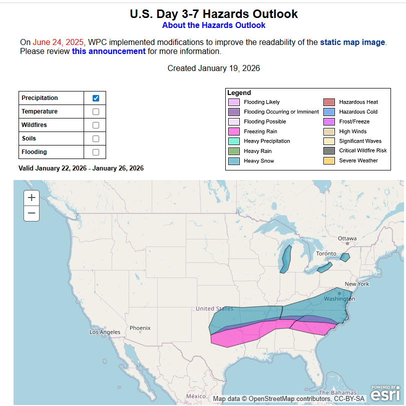
Latest AFD from Mount Holly on the upcoming potential event- KEY MESSAGE 3...There is signal for an impactful winter storm to impact portions of the area this weekend, however quite a bit of uncertainty remains. Signals of the upper level pattern by late week and the weekend becomes quite active between the northern and southern stream jets. The key elements embedded in these features are currently located over the Arctic and the Pacific Ocean, so it`ll likely take a few more days for guidance to become better aligned. In the meantime, almost all available guidance depicts an area of low pressure developing over the Southern Plains on Friday before tracking eastward into the Deep South on Saturday. Beyond Saturday, its uncertain where the track of the low may go. The main player here is the Arctic high to the north and how strong the high becomes. Some guidance depicts a very strong high near 1044mb, which results in a suppressed storm track keeping any significant precipitation to the south. Whereas, a weaker high would result in a more northerly storm track and potentially bringing significant accumulation to the area. Considering that the system is 5-6 days out, the signal for a winter storm to impact at least portions of the area do appear to be stronger than usual. In fact, snow probabilities of the NBM show a 40-60% chance of 2+ inches of snow and a 20-40% chance of 6+ inches of snow for areas south of Philadelphia. Probabilities do lessen further north. Even the Probabilistic Winter Storm Severity Index (WSSI-P), depicts a 40- 60% chance of moderate level winter storm impacts to the south of Philadelphia. Obviously a lot can change between now and the weekend, but users should keep a close eye on the forecast over the coming days.
-
Weeklies are incredible in the east through February 20.
-
Surprised nobody posted the zoomed in version of the AIFS 360 hour map. It's insane and I can't imagine it verifying, but it surely shows the potential of the pattern. Also, I know this is the NYC forum, but I was wondering if anyone had access to the AIFS ZR maps for the southern US at least for the 1/25 storm, which is looking pretty "real" right now. The CMC and Euro are bad enough and if they verify, the ice may be the biggest story with this storm (and if the AIFS is right, it'll likely be close to the CMC ice map as they're close on snowfall for 1/25), but given how good the AIFS has been would love to see that map. TIA.
-
I feel jaded having lived through the Jan/Feb 2015 "Winter Blitz" up in Boston. Two 20-inchers + two 15-inchers in just 20 days.
-
I was just poking around the Euro and had to go all the way down to Rocky Mount/Raleigh before a warm nose at 725mb showed up. It is amazing how cold these runs are.
-
Freezing rain all the way down to the central South Carolina coast ? really ?
-
They definitely are similar. Ratios were high with that Storm over Northern Forum Area. If Models are correct this one may have more Moisture.
-

2025-2026 ENSO
TheClimateChanger replied to 40/70 Benchmark's topic in Weather Forecasting and Discussion
CPC nails it again. -
Okay I watched so you don't have to. To summarize he says that he thinks he it is gonna cut for no real scientific reason other than probably because he live in the midwest and that “these come northwest typically”. I should have stopped watching when he said that he is a Notredame fan but temporarily he will be an Indiana fan because they are good. Anyways he is probably guessing right and we are gonna get sleet because we suck at snow.
-
Don’t think we need to be worried about earliness yet. We’re only a couple hours away from it being dark enough to maybe catch some sightings and I don’t think we’re done with the initial shock of this CME. If the CME is all shock and not much behind it yeah could miss out, but it looked like a good one.
-
I was literally just telling my son about Feb 2010 the other day before this storm showed up. I really hope my kids get to see something like that.
-
I'm fine with NC/VA border and southern VA being shown with the high totals. That almost never verifies unless the storm is suppressed and slide under us. A miss to the south is possible but not all that concerning at the moment. If significant accumulations make it well into PA it is highly likely that areas to the south are experiencing heavy sleet and zr even with a strong HP. This type of storm will almost end up with the bullseye somewhere in the northern Mid-Atlantic. We've seen the GFS remain very stubborn with these type of set ups. Maybe it comes around sooner than later but also may not get on board until late Thursday/Friday. Wrong Thread. lol
-
Also noticed something similar when assessing the analogs posted back in the Medium Range channel. Very likely the case, but the surface progs are uncanny in similarity. More ways to skin a cat I’m sure. I’m hesitant to sound the full alarm yet since we still have plenty of time to go, but I do like seeing the main players on the field already with the initial impacts into the plains less than 72 hrs away. Seems like we are gearing up for a long week of tracking…at a minimum. I’m still wary of a suppression in this setup, but every monster storm comes with some worry.
-

E PA/NJ/DE Winter 2025-26 Obs/Discussion
Hurricane Agnes replied to LVblizzard's topic in Philadelphia Region
That's what prompted my sis to text this morning (Apple app). She is in Delco and hers said 11" - 13". As a quick obs, I bottomed out at 15 and so far hit 33 for a high. Currently 32 with dp 23 and lots of puffy cumulus. -
=
-
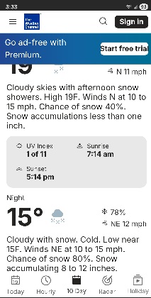
Weather Channel has forecasted for Magnolia Delaware
-
Does the blend of models include AI models too? .
-
They’re concerned like many others with suppression
-
Ok just looked at the GEFS and EURO AI Ens runs. They look supportive of the GEFS and EPS respectively, but more juiced up.
-
Thanks - I also like your discussion write up in the new thread - very well written.
-
Damn. Hope we didn’t peak too early. Imagine if this happened after a snowfall… lights reflecting off snow in the mid-Atlantic
-
I never even realized it did it until last year. My teenage son has it and he would show me that it would go from 3 to 6 inches of snow something like that if that's what the European model was showing for where we live. And then the next day if it went up to 8 to 12 it would show that on the next model. And then if even the next model it went to one to 2 inches it would show that it's completely ridiculous
-

E PA/NJ/DE Winter 2025-26 Obs/Discussion
Newman replied to LVblizzard's topic in Philadelphia Region
So obviously I don't live in SE PA anymore, I've got a comfortable met job in Florida. But these MECS/HECS are just so fun to track and a great way to keep my meteorology skills sharp. My met job down here in Florida is so focused on tropical weather, except this past weekend with the snow haha. Man I was getting so bored of sea breeze convection all summer. When I lived in Berks throughout the 2010s and early 2020s, I think I forgot how rare storms north of 15-18" really are. For Philly, anything above 17" gets you into the top 10 of all time. And it has only snowed 2 feet there twice in recorded history. For ABE, a 20" storm puts you into the top 7 of all time. Of course, the past few years have been rough for big ones and I think it should make this even sweeter (if it does happen, no guarantees yet). We got so used to these MECS during past decades that, personally, I lost sight of how rare and treasured they really are. Remember, places like KPHL go back to the late 1800s and early 1900s sometimes with record keeping. So when you see these model outputs throwing around 1-1.5" of QPF into a cold dome with surface temps in the lower teens, you're immediately talking about something that has only happened maybe a handful of times in like 100 years. That in and of itself makes me appreciate just tracking the opportunity for something like that. -
The upper levels are very similar to the January 6-7, 1988 snowstorm. If anyone wants to catch up to how that transpired, feel free to take a look at this video from back in the day....