All Activity
- Past hour
-
Brace yourselves... Let's at least get some Foxboro snow mojo in the air Sunday
-
Maybe the "boo-birds" will be throwing snow balls, not hot water, on Sunday.
- Today
-
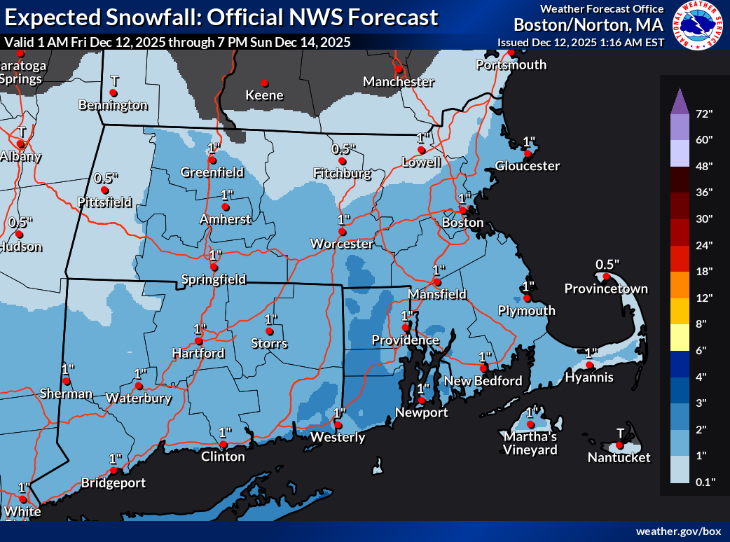
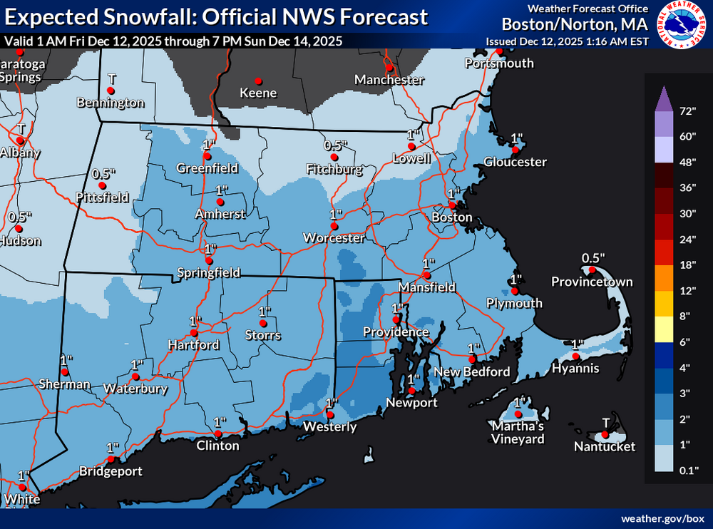
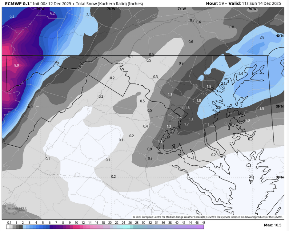
18z NAM was an example... on that run, more energy was able to compensate a little for the worse tilt and southeast squash To echo what CoastalWx and others have said... I remember the occasions, felt like a few times every season, when we were micro-analyzing such details with huge stakes on the eve of classic KUs. Now the stakes are a few inches and it's tiring. 0z Euro continued to tick the trough more positive and outcome more southeast... maybe 1-3" south coast, 3-4" outer Cape. 0z AIFS a hair better.
-

Minor snow possible sunday 12/14/25
coastalplainsnowman replied to WeatherGeek2025's topic in New York City Metro
There seems to be a hard cap of about 35% happiness here. -

December 2025 regional war/obs/disco thread
Snowcrazed71 replied to Torch Tiger's topic in New England
Isn't the euro out soon? -

Minor snow possible sunday 12/14/25
RU848789 replied to WeatherGeek2025's topic in New York City Metro
My point was that they could've issued a 72-hour map (that's as far out as they issue them, which I'm fine with) at 18Z that went through 18Z Sunday, which is past the end of the storm, but they waited until 0Z to do so. Plus, I think issuing a map through only 12Z Sunday, without clearly noting that snow wasn't over yet is more than a little misleading and something they shouldn't do, IMO. -
.thumb.png.4150b06c63a21f61052e47a612bf1818.png)
December 2025 regional war/obs/disco thread
HIPPYVALLEY replied to Torch Tiger's topic in New England
Lets do it! -

December 11th - 12th clipper potential
John1122 replied to Holston_River_Rambler's topic in Tennessee Valley
Looks like I'm gonna finish up at about 1.5 inches. Shocked by this one. -
Sticking with the NBM on this one. Expectations should be 1-3 for many east of 15 with perhaps a 4” lolli where things line up just right - looking to likely be NE of Baltimore, my guess is somewhere near elk neck state park along the bay
-

December 2025 regional war/obs/disco thread
weathafella replied to Torch Tiger's topic in New England
lol…skynet with the Christmas Eve sizable snowstorm. -
December 2025 regional war/obs/disco thread
HIPPYVALLEY replied to Torch Tiger's topic in New England
Brisk night. 20F with a fresh breeze and some good gusts. I'll probably go test/measure the ice on a local lake on Sunday. Should be several inches of black ice by then. -

December 11th-14th Double Banger Clippers
Radtechwxman replied to Jackstraw's topic in Lakes/Ohio Valley
Im definitely worried about another south trend. 0z euro and 0z nam's still look solid for you. Gfs was the most south. Hrrr/rap decently north as well but they also were night before this current event. -
December 2025 regional war/obs/disco thread
HIPPYVALLEY replied to Torch Tiger's topic in New England
Still looks like a few inches of fluff is possible for the S Coasts and the Cape. Parts of CT/RI too. -

12/14: Sunday funday? Will the south win again?
Maestrobjwa replied to TSSN+'s topic in Mid Atlantic
Seems like a step toward the GFS though...although precip distribution looks different. -
0z Euro shifted SE. Bottom line is that we have no idea what will happen, other than the fact that it will likely snow somewhere along the I-95 corridor
-

December 11th-14th Double Banger Clippers
cyclone77 replied to Jackstraw's topic in Lakes/Ohio Valley
00z are ticking southwest. Looks like another dog turd duster here at best. Bring on the torch. -

12/12: The little Friday clipper that could? Or won't.
pazzo83 replied to dailylurker's topic in Mid Atlantic
Ji - take a hike bro. -

Minor snow possible sunday 12/14/25
eduggs replied to WeatherGeek2025's topic in New York City Metro
Right now the best shot at moderate snow accumulations based on a model consensus would be I-95 east in CNJ and maybe into Long Island. -
December 11th - 12th clipper potential
John1122 replied to Holston_River_Rambler's topic in Tennessee Valley
Really heavy burst underway currently. Maybe the heaviest of the evening. -

12/12: The little Friday clipper that could? Or won't.
ravensrule replied to dailylurker's topic in Mid Atlantic
We love you @Jebman, don’t listen to the haters they’re all jealous. -

December 2025 regional war/obs/disco thread
SnowGoose69 replied to Torch Tiger's topic in New England
I find it funny all top 3 CIPS analogs (12/5/92, 12/8/06 12/13/86) are sort of close at 500, every one was a nothing event with no snow anywhere from what I can tell, 12/5/92 was an epic bust, we had WSWs out down here and saw nothing, I think they actually dropped them late afternoon on 12/5 after putting them out at 4-5pm on 12/4. -

12/14: Sunday funday? Will the south win again?
Whitecheddar replied to TSSN+'s topic in Mid Atlantic
I would let someone else eat a shoe! -

December 2025 regional war/obs/disco thread
WinterWolf replied to Torch Tiger's topic in New England
Listening to TBlizz everything is gone. -

December 11th - 12th clipper potential
Icy Hot replied to Holston_River_Rambler's topic in Tennessee Valley
Ground is white in Colonial Heights as snow showers continue. -

December 11th-14th Double Banger Clippers
Jackstraw replied to Jackstraw's topic in Lakes/Ohio Valley
Such are Clippers. They are delaying schools by 2 hours everywhere around here and we may not even get any lol.