All Activity
- Past hour
-
Tornado possible in the warning for Belchertown
-
Come to papa

-
Clearly on the north shore, would be a nightmare day on the south shore. Ripping onshore wind and temps around 55.
-
Severe warning on the right-moving Mt Airy cell
-
Just got home no rain here but looks like the wind probably got pretty strong small branches down everywhere
-
I can see a shelf arriving!!!!!!

-
Machines ahead of the humans on this one-models backed off 36 hrs ago
-
Got to the parking lot just up the road. Thankfully it’s only a 3 minute drive. Got here and realized I forgot my camcorder and had to go back home
-
This is pretty darn good for 5/3. Microburst Hampton NH earlier.
-

Central PA Spring 2025
Itstrainingtime replied to canderson's topic in Upstate New York/Pennsylvania
Storms in MD and WV already have solid hail cores as they advance NE towards the Mason/Dixon. -
Damage!
-
40% chance of t'storm watch.
-
New England “severe”.
-
Winsted is meh too. I'm here now.
-
Pretty wild winds as that moved through here in New Hartford!
-
Looks like cool & wet conditions thru mid May. That’s a win in my opinion. Means at least not wall to wall hot & maybe just maybe a wetter summer & no drought. Yep wetter soil means more humidity but not usually extreme heat.
-
Aside from Winsted looks meh.
-
I wasn’t thinking they’d hold together here. But maybe a weak cell holds
-
Car is getting Powerwashed
-
Gonna uninstall those ACs for you?
-
Windy here now too
-
Wind is nuts car rocking
-
Wind kicking up
-
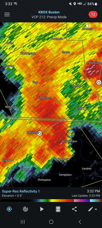
LFG just saw a crazy cloud to ground strike!! In winchendon
-
Looks like a nice bow west of Hotford