All Activity
- Past hour
-

July 2025 Obs/Disco ... possible historic month for heat
CoastalWx replied to Typhoon Tip's topic in New England
Euro is a little further north. Probably a good thing since I do agree with these sometimes being further south than modeled. -

July 2025 Obs/Disco ... possible historic month for heat
weatherwiz replied to Typhoon Tip's topic in New England
The NAM/Euro may have a bit of convective feedback going on -

July 2025 Obs/Disco ... possible historic month for heat
Torch Tiger replied to Typhoon Tip's topic in New England
It looks very Stein the next few weeks, hopefully mid-week rain trends a bit more north -

July 2025 Obs/Disco ... possible historic month for heat
Brian5671 replied to Typhoon Tip's topic in New England
Moved north a bit but most models now showing a big rain event-details to be worked out -
This is not a counterargument lol
-

July 2025 Obs/Disco ... possible historic month for heat
WxWatcher007 replied to Typhoon Tip's topic in New England
Euro not backing down for Thursday/Friday. -
12z euro selling more of the goods
-
I don't think that will happen.
-

July 2025 Discussion-OBS - seasonable summer variability
bluewave replied to wdrag's topic in New York City Metro
Well the ridge axis has been further west than recent years. Recent summers it has been east of New England with more onshore flow. So this is why places like JFK have seen more 100° days with the increased westerly flow.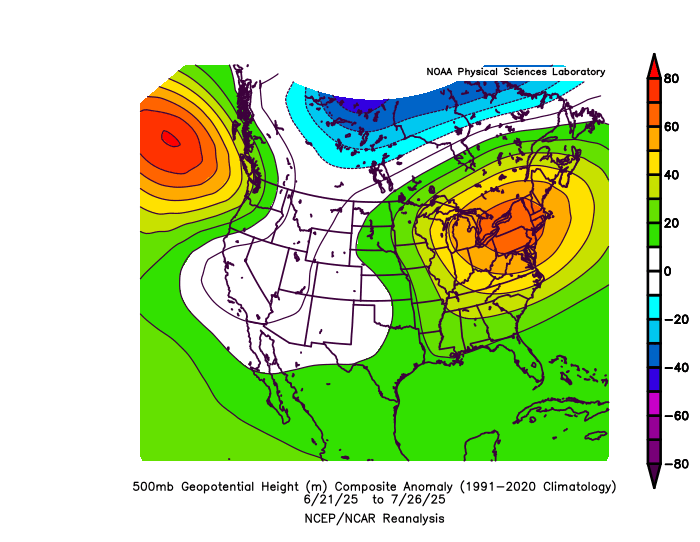
-
They would still need approval to move it elsewhere in the Park.
-

July 2025 Discussion-OBS - seasonable summer variability
Roger Smith replied to wdrag's topic in New York City Metro
Today and Wednesday (30th) are the only two days of the year where four years share the record high for NYC. Today (97) is 1892, 1931, 1949 and 1999. For Wednesday 30th (98) the four years sharing the record are 1917, 1933, 1940 and 1988. In between on 29th, 1949 (99F) has sole possession. There are eight days during the year where the record high is shared by three years. Two of these fall on Aug 18 and 19 during the next notable relatively cool spell for record highs (97 is tops for Aug 15 to 25, the two three-way ties are both 94). In between the two relatively cool intervals, July 31 to Aug 14 average record high is 99.8 F. Then again, from Aug 26 to Sep 3 the average returns to 100F, but most of those records are from two years, 1948 then 1953 (1929 had 99F on Sep 3). -
Heat Advisory URGENT - WEATHER MESSAGE National Weather Service Pittsburgh PA 113 PM EDT Mon Jul 28 2025 OHZ039>041-048>050-057>059-068-069-PAZ013-014-020>022-029-031-073- 075-WVZ001>004-012-021-509-290600- /O.NEW.KPBZ.HT.Y.0003.250729T1600Z-250730T0000Z/ Tuscarawas-Carroll-Columbiana-Coshocton-Harrison-Jefferson OH- Muskingum-Guernsey-Belmont-Noble-Monroe-Lawrence-Butler-Beaver- Allegheny-Armstrong-Washington-Greene-Westmoreland-Fayette- Hancock-Brooke-Ohio-Marshall-Wetzel-Marion-Monongalia- Including the cities of New Martinsville, St. Clairsville, New Kensington, Columbiana, Follansbee, Murrysville, Aliquippa, Dover, Latrobe, Woodsfield, Salem, Coshocton, Monaca, Pittsburgh Metro Area, Steubenville, Cadiz, Caldwell, Ambridge, Malvern, Kittanning, Butler, Cambridge, New Castle, Ford City, Martins Ferry, Ellwood City, Greensburg, Wellsburg, Wheeling, East Liverpool, Carrollton, Zanesville, Weirton, Fairmont, Waynesburg, Monessen, New Philadelphia, Lower Burrell, Moundsville, Morgantown, Uniontown, Beaver Falls, Washington, and Canonsburg 113 PM EDT Mon Jul 28 2025 ...HEAT ADVISORY IN EFFECT FROM NOON TO 8 PM EDT TUESDAY... * WHAT...Heat index values up to 103 expected. * WHERE...Portions of east central Ohio, southwest and western Pennsylvania, and northern and the northern panhandle of West Virginia. * WHEN...From noon to 8 PM EDT Tuesday. * IMPACTS...Hot temperatures and high humidity may cause heat illnesses. PRECAUTIONARY/PREPAREDNESS ACTIONS... Drink plenty of fluids, stay in an air-conditioned room, stay out of the sun, and check up on relatives and neighbors. && $$
-
It's usually the same "have nots" year after year. Geographic influences are real, and a bitch.
-
Similar boat here and, frankly, maybe more of a micro because I’m right up against Gambrill State Park/Watershed. Grass is not just a tint of brown, but legitimately getting brown.
-
July 2025 Obs/Disco ... possible historic month for heat
weatherwiz replied to Typhoon Tip's topic in New England
Oh man look at this from the 12z NAM for DSM this evening. Those CAPE numbers are ridiculous. 1450 Hail CAPE...WOOOOOOWWWWWW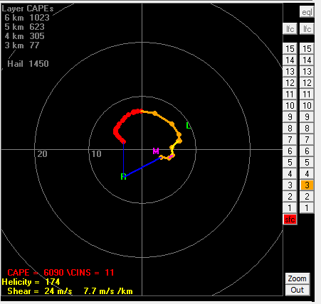
-
July 2025 Discussion-OBS - seasonable summer variability
bluewave replied to wdrag's topic in New York City Metro
None of the models had 100° today anyway. The heat was always expected to peak Tuesday into Wednesday. Smoke only becomes an issue for temperatures when it’s thick enough. Even then the effect would only be a degree or two unless we have June 2023 levels which was historic due to the magnitude and closeness of the wildfires in Canada. The current wildfires are further away in Canada so it hasn’t been as thick as 2023. But a few days ago the low level smoke was thick enough to drop the air quality. -

July 2025 Obs/Disco ... possible historic month for heat
Typhoon Tip replied to Typhoon Tip's topic in New England
I'm a little suspicious the GFS is over mixing ... It's got 2-m DPs under 60 F N of the Pike around 21z here shortly, where it is presently 67 to 71. It's an interesting test for tomorrow - it's possible that mixing DPs out may be goosing the kinetic temps -
Stuck at 80 with all the debris clouds, even with the Heat Advisory in effect today. No way we're going to top 90 or even the upper 80s. NWS might as well just cancel the Heat Advisory today.
-

July 2025 Discussion-OBS - seasonable summer variability
LibertyBell replied to wdrag's topic in New York City Metro
The clouds are way more of a problem than any smoke, it shot up to 95 here 30 minutes ago but it's been mostly cloudy since then and temperatures have dropped, even on a land breeze day, the clouds screwed us out of 100 today. Now I see why 100 degrees was much more common for the city and here between 1944-1966, it was much less cloudy and moist back then. I will say this is a busted forecast because NO ONE expected it to be cloudy today in the afternoon. - Today
-

2025 Short Range Severe Weather Discussion
CheeselandSkies replied to Chicago Storm's topic in Lakes/Ohio Valley
Kind of surprised at the 1630Z expansion of the moderate. Recent HRRR runs have trended toward less organized clusters as opposed to the high-end derecho on last night's 0Z. -
July 2025 Obs/Disco ... possible historic month for heat
Typhoon Tip replied to Typhoon Tip's topic in New England
it's baaaaaaaack -
oh ok never mind
-
Bob Ross and his happy little clouds. (One either gets that or they don't)
-

July 2025 Obs/Disco ... possible historic month for heat
powderfreak replied to Typhoon Tip's topic in New England
That weather will include you two clowns too lol. Region wide. Isn’t this what you’ve been posting about for the last week? The start to August that looks great?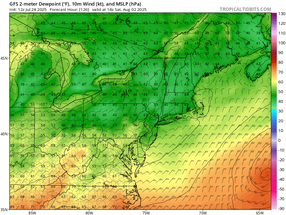
-

July 2025 Discussion-OBS - seasonable summer variability
LoboLeader1 replied to wdrag's topic in New York City Metro
91/70 here


