All Activity
- Past hour
-

December 2025 regional war/obs/disco thread
WinterWolf replied to Torch Tiger's topic in New England
Can you post the mean? -
It's like clockwork ain't it?
-
There are other factors like the weakening La nina , MJO , etc.
-

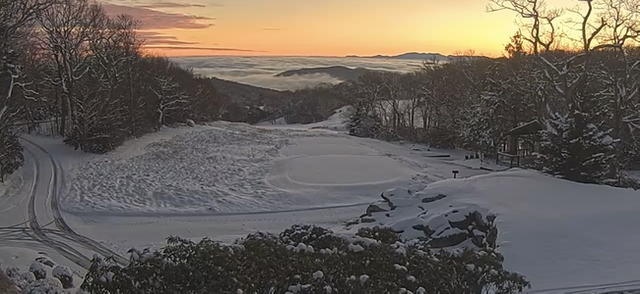
2025-2026 Fall/Winter Mountain Thread
nchighcountrywx replied to Buckethead's topic in Southeastern States
Grateful that we live in such a beautiful region of the state of NC. To God be the glory for all that he has made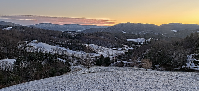
-

December 2025 regional war/obs/disco thread
Baroclinic Zone replied to Torch Tiger's topic in New England
Some flop worse than LeBron James. - Yesterday
-
It will turn briefly milder tomorrow. Some rain showers are likely tomorrow night. Some wet snow showers could occur well north and west of New York City. It will then turn somewhat cooler for the remainder of the week, but the cold won't match today's chill. Light precipitation is possible during the weekend, especially on Sunday. The ongoing stretch of below normal temperatures will likely continue into or through the second week of December. December 1-10 will be a solidly colder than normal period. The potential exists for the coldest first 10 days of December since at least 2007 (33.4°, 5th coldest December 1-10 since 2000). The five coldest December 1-10 periods since 2000 were: 1. 30.6°, 2002 2. 32.2°, 2003 3. 32.4°, 2000 4. 33.1°, 2005 5. 33.4°, 2007 All 5 of these cases had measurable snowfall in Central Park. The WPO is forecast to become strongly negative beyond December 10th. That would likely contribute to the December 10-20 period also being colder to perhaps much colder than normal overall. The probability that December 2025 will have a maximum monthly temperature below 60° is increasing. The last time that happened was in 2019 when the monthly high was 58°. If 2025 has a monthly high below 60°, that would be only the fifth such occurrence since 2000 (2003, 2004, 2005, and 2019 are the cases since 2000). The ENSO Region 1+2 anomaly was -0.2°C and the Region 3.4 anomaly was -0.5°C for the week centered around December 3. For the past six weeks, the ENSO Region 1+2 anomaly has averaged -0.27°C and the ENSO Region 3.4 anomaly has averaged -0.65°C. La Niña conditions will likely continue through at least mid-winter. The SOI was +17.96 today. The preliminary Arctic Oscillation (AO) was -0.921 today. Based on sensitivity analysis applied to the latest guidance, there is an implied near 91% probability that New York City will have a cooler than normal December (1991-2020 normal). December will likely finish with a mean temperature near 34.1° (5.0° below normal). Supplemental Information: The projected mean would be 3.4° below the 1981-2010 normal monthly value.
-

2025-2026 ENSO
PhiEaglesfan712 replied to 40/70 Benchmark's topic in Weather Forecasting and Discussion
This only works if December torches, like in 2015, 2021, or 2023. A cold December, like this one, makes it more likely, based on the law of averages, a torch will happen in January. The period of winter might already be happening. -

December 2025 regional war/obs/disco thread
40/70 Benchmark replied to Torch Tiger's topic in New England
Welcome aboard. -
.thumb.jpg.6a4895b2a43f87359e4e7d04a6fa0d14.jpg)
Central PA Winter 25/26 Discussion and Obs
Yardstickgozinya replied to MAG5035's topic in Upstate New York/Pennsylvania
Its elevation dependent . Only those that live high enough in the mountains of wv might see blizzard conditions. -
I'd take those ECM runs every time. Weekend, daytime snow. 8-12hr duration. Temps freezing or below. We pray.
-
i don't think I want that!
-

Mid to long range discussion- 2025
WinstonSalemArlington replied to wncsnow's topic in Southeastern States
-

December 2025 regional war/obs/disco thread
Snowcrazed71 replied to Torch Tiger's topic in New England
I deleted my post. I realize you probably were talking about him. I don't find him to be all that bad. Not compared to a lot of these other bozos. -

December 2025 regional war/obs/disco thread
SouthCoastMA replied to Torch Tiger's topic in New England
Glass half full: Most are above average snowfall by 12/15 with 9/10 days left for models to mute the Christmas torch and associated cutter, if still applicable -
December 2025 regional war/obs/disco thread
WinterWolf replied to Torch Tiger's topic in New England
Whoa….I somewhat positive post; are you ok? Delirious from fever? -
actually way better
-
EPS also better
-
December 2025 regional war/obs/disco thread
40/70 Benchmark replied to Torch Tiger's topic in New England
Not you...the northeast weather alerts guy you referenced. -
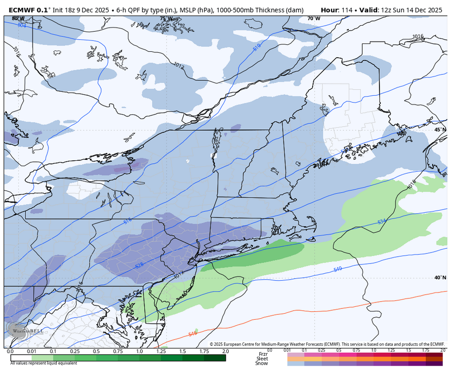
The Friday system is moisture starved and the Sunday one is basically a cold front with most of the energy further north: https://www.tropicaltidbits.com/analysis/models/?model=gfs®ion=us&pkg=z500_vort&runtime=2025120918&fh=114 I guess we can find a way into a light snow event from both systems, but the real snow producers are when we get some southern stream influence which has been really hard to come by in these neck of the woods.
-
Back up to 13.5/3.6°F so that was short lived.
-

Central PA Winter 25/26 Discussion and Obs
Blizzard of 93 replied to MAG5035's topic in Upstate New York/Pennsylvania
18z Euro keeps us in the game for the late Saturday night into Sunday chance.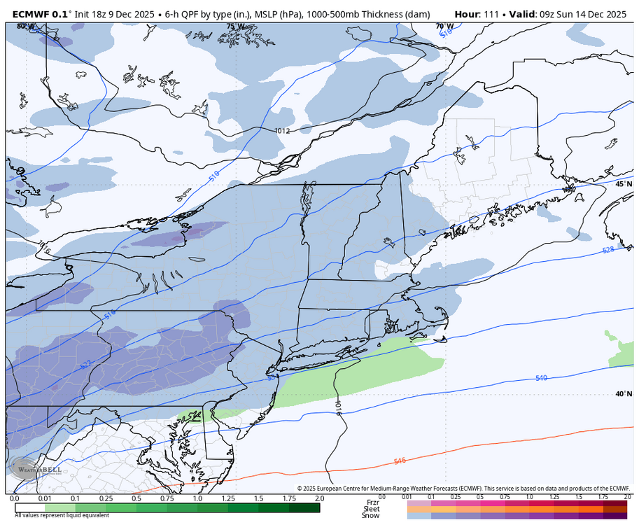
-
The CAPE storm
-
Please work out
-

December 2025 regional war/obs/disco thread
TauntonBlizzard2013 replied to Torch Tiger's topic in New England
Wow, that might be the best look we’ve had in years here if that verified -
pretty soon we won't even have to post on here AI will post for us knowing what we would say and when we would say it


