All Activity
- Past hour
-
If this weekend pans out, I will be pretty satisfied. Usually we spend December talking about snow chances in Jan and Feb. Now it's like having multiple threats in Jan but in Dec. I like the trend so far. Always a chance to over perform.
-

December 2025 regional war/obs/disco thread
weatherwiz replied to Torch Tiger's topic in New England
IMO, there's alot more that needs to happen than just trending west but I am also not necessarily sold on some of the recent trends we have seen with the ridging and better interaction of the two energies...we've seen this happen plenty of times of late where within this time range (3-5 days) there are these subtle shifts which trend better. I suspect by 12z Friday we will begin to see a trend back in the opposite direction with the heights in the west and energy interaction. Also, even with the better interaction of energies, the upper level dynamics still aren't very favorable for low pressure development at the sfc...we have to look closer to where the baroclinic zone is present to get some llvl spinup present and I think its just too far south to do any good for us. But that said, at least snow showers are still possible farther east. -
Oh, I didn't know. I don't understand people like that.
-

E PA/NJ/DE Winter 2025-26 Obs/Discussion
geeter1 replied to LVblizzard's topic in Philadelphia Region
Really did overperform !!! Thinking it could last another hour or so. Roads up here are caving even though they were treated from the last storm. Hopng for good outcome this weekend. Things seem to be coming in to agreement for something more than an inch... -

12/12: The little Friday clipper that could? Or won't.
TSSN+ replied to dailylurker's topic in Mid Atlantic
Seeing how it’s like the only model showing anything not too enthusiastic yet. Need something else to get on board. Will see what Nam shows shortly. -

December 2025 regional war/obs/disco thread
SouthCoastMA replied to Torch Tiger's topic in New England
Euro advertises some hang back moisture along coast/Cape Sunday evening, might be ocean enhanced as the low strengthens offshore -
Psuhoffman said something that stuck with me, we've always been right on the line with events that would go in our favor. Now we seem to be just on the wrong side of that line, instead of just on the right side.
-

E PA/NJ/DE Winter 2025-26 Obs/Discussion
LVblizzard replied to LVblizzard's topic in Philadelphia Region
Same in Allentown now. This is overperforming a little bit. Steady snow which is sticking to the grass and my car. Looks like the R/S line is way south of here too with a snow report near Boyertown. I love these little surprise events. -

Central PA Winter 25/26 Discussion and Obs
Boreal replied to MAG5035's topic in Upstate New York/Pennsylvania
Bangor PA. 33° snow, 0.5” -

Winter 2025-26 Short Range Discussion
A-L-E-K replied to SchaumburgStormer's topic in Lakes/Ohio Valley
-
Crazy how that came true a month out (albeit with smaller amounts)
-

12/12: The little Friday clipper that could? Or won't.
NorthArlington101 replied to dailylurker's topic in Mid Atlantic
Looks better put together on TT but this is still a buy at this point for sure -
If this Sat/Sun event pans out - we get pretty lucky with the timing of the onset. It’s honestly not that cold when precip starts (euro actually at 33° for the beltway). Cmc is rain. If this was during the day it might have been even tougher. It’s never easy.
-

Winter 2025-26 Short Range Discussion
ILSNOW replied to SchaumburgStormer's topic in Lakes/Ohio Valley
riding the HRRR and RAP -

December 2025 regional war/obs/disco thread
WinterWolf replied to Torch Tiger's topic in New England
Drive up to Aroostook a couple days after…the ice on the way up was immense in central areas. And yes, that’s why we went up…the northern part of the county was buried. It was a scene for sure. -
https://news.ucar.edu/14009/snowfall-measurement-flaky-history But when we turn to snowstorms in the Northeast, or elsewhere in the U.S., there is an additional factor at work when comparing modern numbers with historical ones. Quite simply, our measuring techniques have changed, and we are not necessarily comparing apples to apples. In fact, the apparent trend toward bigger snowfalls is at least partially the result of new—and more accurate—ways of measuring snowfall totals. Climate studies carefully select a subset of stations with consistent snow records, or avoid the snowfall variable altogether. Earlier in our weather history, the standard practice was to record snowfall amounts less frequently, such as every 12 or 24 hours, or even to take just one measurement of depth on the ground at the end of the storm. You might think that one or two measurements per day should add up to pretty much the same as measurements taken every 6 hours during the storm. It’s a logical assumption, but you would be mistaken. Snow on the ground gets compacted as additional snow falls. Therefore, multiple measurements during a storm typically result in a higher total than if snowfall is derived from just one or two measurements per day. That can make quite a significant difference. It turns out that it’s not uncommon for the snow on the ground at the end of a storm to be 15 to 20 percent less than the total that would be derived from multiple snowboard measurements. As the cooperative climate observer for Boulder, Colorado, I examined the 15 biggest snowfalls of the last two decades, all measured at the NOAA campus in Boulder. The sum of the snowboard measurements averaged 17 percent greater than the maximum depth on the ground at the end of the storm. For a 20-inch snowfall, that would be a boost of 3.4 inches—enough to dethrone many close rivals on the top-10 snowstorm list that were not necessarily lesser storms! Another common practice at the cooperative observing stations prior to 1950 did not involve measuring snow at all, but instead took the liquid derived from the snow and applied a 10:1 ratio (every inch of liquid equals ten inches of snow). This is no longer the official practice and has become increasingly less common since 1950. But it too introduces a potential low bias in historic snowfalls because in most parts of the country (and in the recent blizzard in the Northeast) one inch of liquid produces more than 10 inches of snow. This means that many of the storms from the 1980s or earlier would probably appear in the record as bigger storms if the observers had used the currently accepted methodology. Now, for those of you northeasterners with aching backs from shoveling, I am not saying that your recent storm wasn’t big in places like Boston, Portland, or Long Island. But I am saying that some of the past greats—the February Blizzard of 1978, the Knickerbocker storm of January 1922, and the great Blizzard of March 1888—are probably underestimated. So keep in mind when viewing those lists of snowy greats: the older ones are not directly comparable with those in recent decades. It’s not as bad as comparing apples to oranges, but it may be like comparing apples to crabapples.
-
Central PA Winter 25/26 Discussion and Obs
geeter1 replied to MAG5035's topic in Upstate New York/Pennsylvania
We have about .50" here in northern Lehigh Valley with temp sitting at 32.3° -
December 2025 regional war/obs/disco thread
WinterWolf replied to Torch Tiger's topic in New England
And that’s my point…what a nasty guy he is. Someone posts a gorgeous picture of skiing, and he puts a shit emoji. Dweeb in the purest sense. -
Man, does that bomb out after it departs...Epic storm for Newfoundland.
-
.
-

Winter 2025-26 Short Range Discussion
Chicago Storm replied to SchaumburgStormer's topic in Lakes/Ohio Valley
we saw this exact scenario with the event last weekend. -
The cold stayed wedged in here today. Forecast high was 46. Currently raining and 37.
-

2025-2026 Fall/Winter Mountain Thread
Buckethead replied to Buckethead's topic in Southeastern States
Officially, the National Weather Service defines a blizzard as a storm which contains large amounts of snow OR blowing snow, with winds in excess of 35 mph and visibilities of less than 1/4 mile for an extended period of time (at least 3 hours). https://www.weather.gov/fgz/WinterStorms Sent from my Pixel 10 Pro using Tapatalk -
12/12: The little Friday clipper that could? Or won't.
TSSN+ replied to dailylurker's topic in Mid Atlantic
Hrrr probably smokin crack but has nice little event.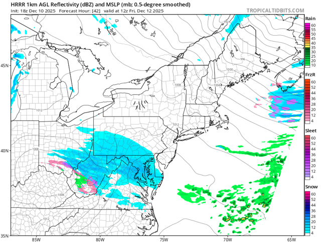
-
Wantage 0.3" at 240P since SB around 150PM. 32.4aF down from a high of 35.2. We had sprinkles at 1025 AM. Driveway snow covered but treated roads just wet.


