All Activity
- Past hour
-
Some of it was luck.
-
Probably your parents‘s greatest accomplishment too
-
Wawa has been so good
-
Outside of one storm, that luckily broke our way, most people would be well below normal on snowfall. It’s definitely been a low QPF winter.
-
You know it's bad when the medium range thread has several plots of the 300+ hour deterministic GFS showing warmth, and relative silence about that. If it were a major snowstorm being shown, everyone would be saying "looks great, but it's the GFS and at 300 hours, no way that happens!"
-

Presidents' day Snow potential
winterwarlock replied to WeatherGeek2025's topic in New York City Metro
Kuchera would be more accurate given its going to be less than 10-1 -
Anyway, nice to see Spring continue popping in the LR
-
Neurosis
-
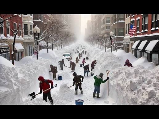
That top pic is clearly AI lol
-
Show me where I predicted a super La Niña or a blowtorch you utter clown. Remember your epic bust with MJO phase 8 for 30 days back in December?
-
 It's not a cold pattern for sure, but the long range ensembles have been rushing warmth in the east for literally months. So a dominating Pac warm pattern is far from a lock imho. Of course, that doesn't mean it's conducive to snow either unfortunately.
 -
 Problem from what I can see in the 00Z GFS around the 24th is that it has a low in southern Canada, which I would guess is kind of messing things up with the main system of interest that would affect us. Maybe not quite the same as a Lakes low, but I'd have to think it isn't ideal.
 -
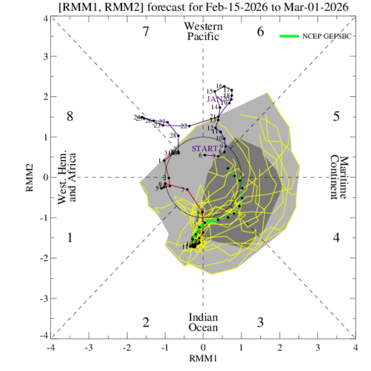
Fwiw, the most recent Bias Corrected Gefs MJO from 2/15 is not as strong with the MJO wave and dumps it back into the COD before the end of February.
-
Not to mention many of us still have an inch or so of liquid on the ground in the snow and sleet that will slowly release this week with the warm up.
-
Yes he did. He busted all winter. He might finally be right here with March .
-
MSP achieved a record high of 54 yesterday. This was somewhat low hanging fruit as record highs over the next week range from the upper 50s to mid 60s.
-
(002).thumb.png.6e3d9d46bca5fe41aab7a74871dd8af8.png)
Early Monday morning 2/16 last minute event OBS/Discussion
ChescoWx replied to The Iceman's topic in Philadelphia Region
I suspect this will be an elevation special with small inch or two of snow with some elevation and white rain to a slushy coating for lower spots. -
 It's a longwave pattern, so the 7+ days of highs in the 50s could happen + days. It probably gets warmer past the end of these ensemble runs honestly vs before. It's far ways out though, but you can nail index and general whole areas-of the hemisphere with the ensembles here. If they had neutral PNA/EPO and US ridging, you could say maybe not.. but the H5 is in a strong state on the ensemble mean so the 1st week of March is probably above average temps
 -
Yea with 8 adult children the worry never stops.
-
You're using Gefs and I'm using Eps. But looking at the 0z Gefs, temps are very similar to Eps. But I just noticed your map above is 378hrs vs 354hrs I used. The Eps only go out 360hrs while Gefs go out to 384hrs. I started with the 354hrs map because you originally posted the first 7 days in March would be in the 50's.
-
Nam slightly better than 6z
.thumb.png.72bd610d1deb1673485128c478e7e94b.png)
-
Epic storm Classic pictures
-
Have to watch for a coastal next week
-
We have 11 other months of the year for rain. Maximize snow.
-
Picked up .60" of precip so far, with a possibility of another .50 with that next line of storms coming. Really needed this rain. Chilly though.


.thumb.png.4150b06c63a21f61052e47a612bf1818.png)


.png.48e77e6fdad3da1f43411d19f68c37b3.png)

