All Activity
- Past hour
-
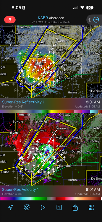
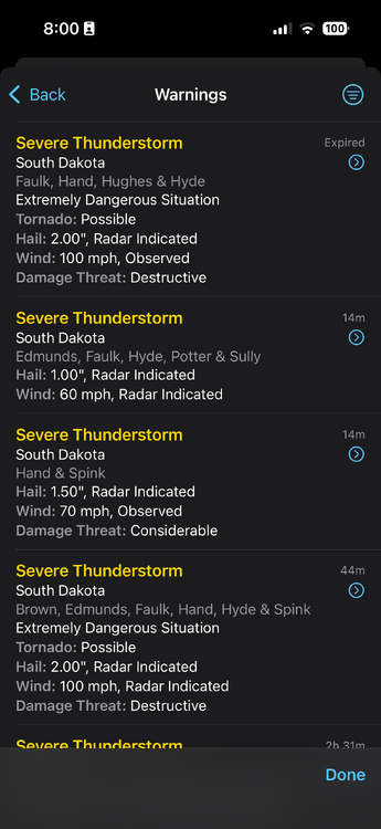
Go to the COD page and watch the 200 frame loop of the radar. It originally formed on the NE/WY border. Accelerated northeast, absorbed or squashed all surrounding convection and turned into this beast. Speaking of which…. What the hell is it? Lol It’s not a supercell, it’s not linear, it’s like an MCB: mesoscale convective blob.
-
Maybe they went after Americanwx too

-
74 / 65 clear. Nice day on tap warm / dry - perhaps an isoloated shower or storm later low - mid 80s. The heat is on Tue - Sun/Mon peaking Wed - Sat (7/1 - 7/4) with upper 90s / low 100s in the hottest spots. Ridge position key and storms or MCS around the periphery of the 594 DM will bring isolated - scattered showers Fri - Sat - Sun but by no means a washout. 7/7 - 7/11 looks warm - hot with intense heat pulling back south and west, but still plenty of heat into theeas. Looks like a trough in the 7/12 - 7/15 period to take us back to normal / below before the next roud of heat expands east right after mid month.
-
Mother In Law visiting for a few days?
-
Here in the lowlands I never doubt heat. This area is the Oswego County of heat. Just like the Tug, when they call for snow, it always happens, and some. Same here with heat
-
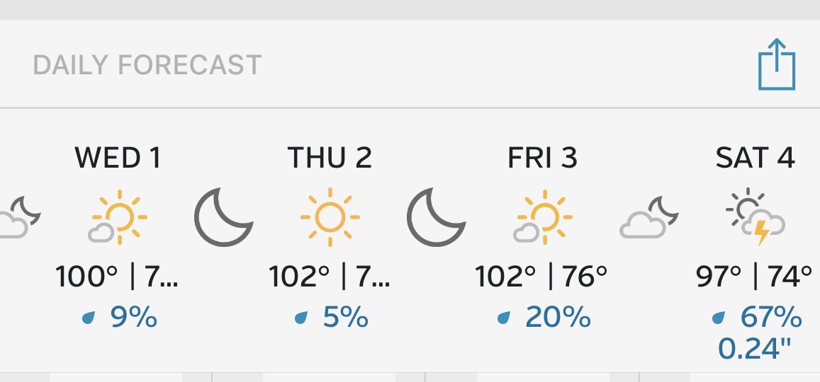
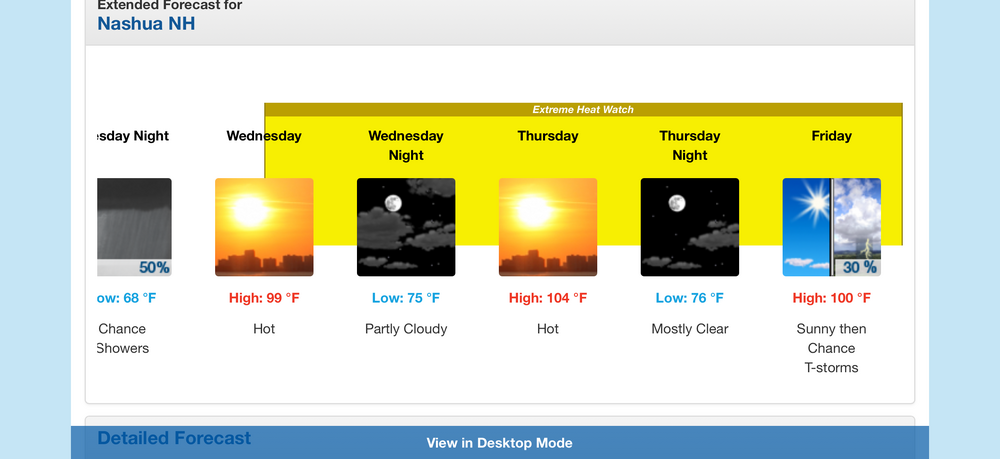
99, 104, 100 forecast for ASH
-
Some more shots from yesterday's brief supercell:
-
Hopefully we can get a noisy visitor Tuesday night or later in the week.
-
Good luck man! Keep posting.
-
Looks like the 00z ( GFS anyway ... ) gave back the petty shaves it was stealing off this signal over those runs. There's still gonna be risks of MCS decay plumes ... or if any wayward linear noctural anything sliding under PF's nuts. Those are built in risks tho. Can't really forecast those until the evidence is obvious
-

2026-2027 Super El Nino
LakePaste25 replied to Stormchaserchuck1's topic in Weather Forecasting and Discussion
The wave started near the Arabian Sea and has been slowly moving east into the MC. It has been destructively interfered with by the Nino and is only able to contribute when it reached the MC because the +AAM temporarily relaxed. Would the west pacific waters in 1997, 1982, 1972 have been cool enough at this point in the summer to stop this forcing? I disagree. -
Missed the heaviest stuff yesterday but picked up 0.27”
-
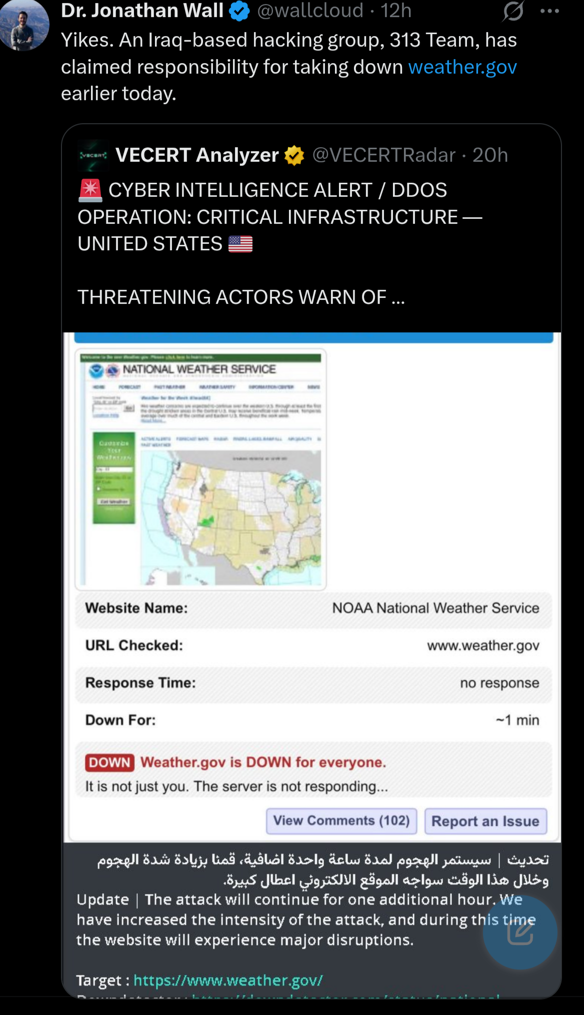
Holy shit
-
Missed the heaviest stuff yesterday but picked up 0.27”
-
Pretty much what dendrite said. Also, add in it’s extremely difficult for us to be directly centered under the ridge so more often than not we’re on the periphery so that opens up the door for high cloud/convective debris. Also, it gets difficult to achieve higher end temps when dewpoints start pushing towards and into the 70’s
-
you're gonna need a bigger Thailand sub-forum
-
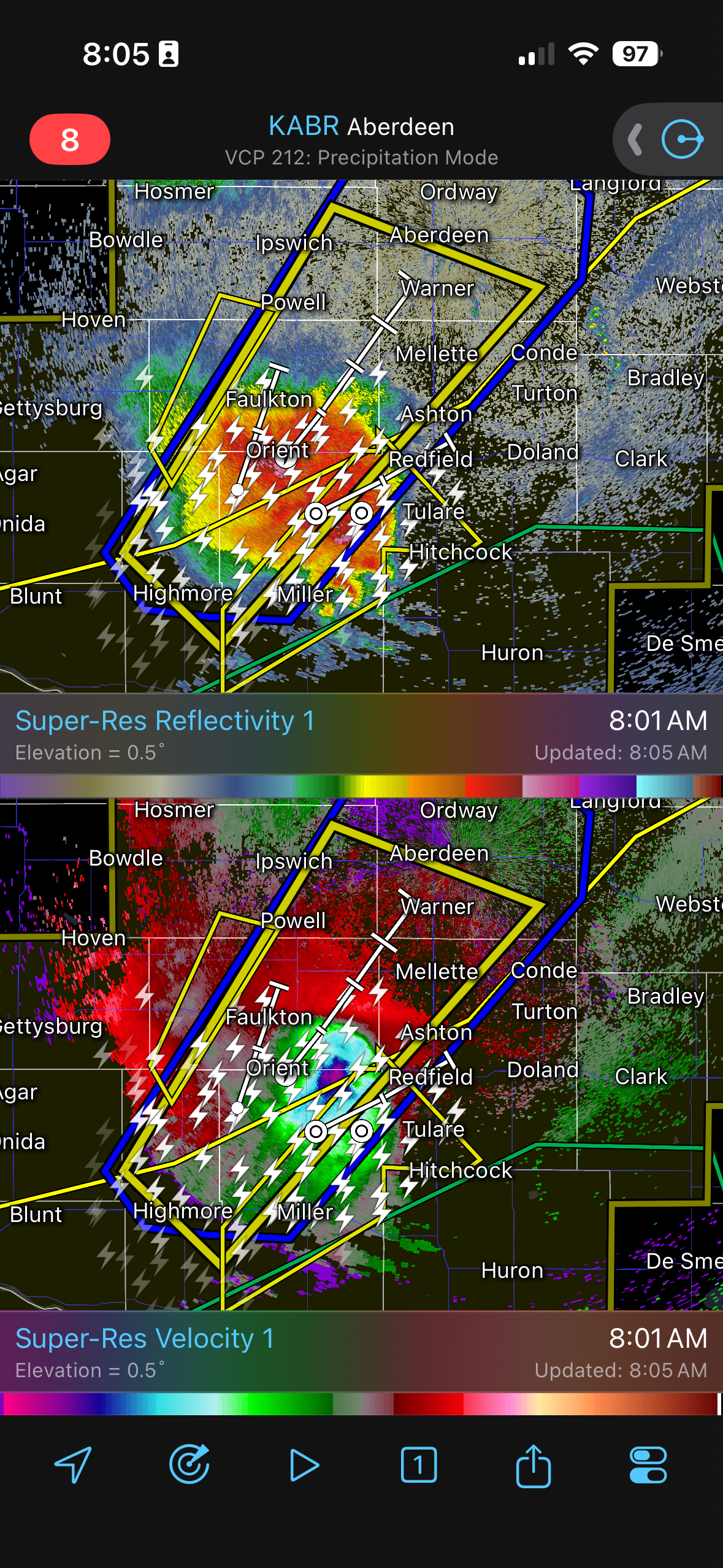
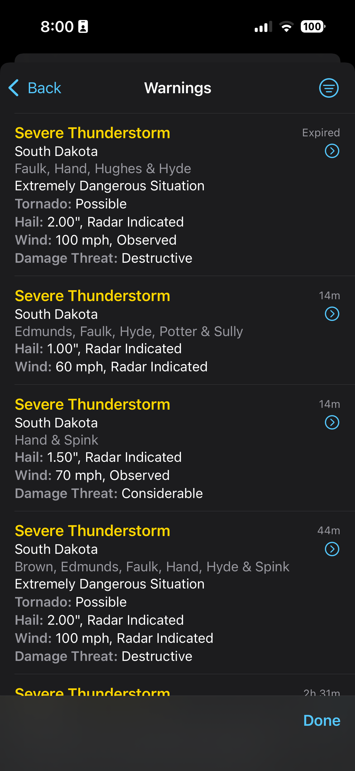
Good morning South Dakota
-
Walking around the houses under construction this week going to be fun lol

-
I'm willing to be you got all giddy posting that
-

Fireworks Heat Contest W 7/1 - S 7/4 for Five MA Airports
RickinBaltimore replied to nw baltimore wx's topic in Mid Atlantic
DCA: 98, 99, 102, 101 BWI: 99, 100, 101, 100 IAD: 99, 101, 102, 102 SBY: 98, 99, 100, 99 RIC: 98, 100, 102, 101 Total Rain: 0.3 -
Looks like Back in the 80’s by weeks end with periodic storm chances as ridge breaks down or slides southeast in these parts.
-

2026-2027 Super El Nino
snowman19 replied to Stormchaserchuck1's topic in Weather Forecasting and Discussion
If my guess is correct that changes come fall once the warm pool gets pushed way east (30C isotherm to 120E) from all the big WWBs/westerlies we are continuing to see this summer and the MC convection gets suppressed/subsidence from the +IOD forcing -
I just don't want it to be 99/82 in my neighborhood like last June's heat wave. That was ridiculous. It does look like 100+ is a lock in the lowlands. How hot can we get? Stay tuned! I think 102F is in reach for areas just away from the water.
-
Are we going to collapse the electrical grid?
-
f- that. it can be hot during the work week, but Friday is a holiday and I'd like to get some yard work done without dying.