All Activity
- Past hour
-

Is we back? February discussion thread
40/70 Benchmark replied to mahk_webstah's topic in New England
I bet CC plays a role in that... -

Feb 4-5 significant SE snow threat
WinstonSalemArlington replied to GaWx's topic in Southeastern States
-
 The modeling seems more of a warmish system. Will see mid week next week how things look.
 -

February 2026 OBS & Discussion
wishcast_hater replied to Stormlover74's topic in New York City Metro
Just measured 13.5” as of 5 pm. . -
 GFS already a little different out west. Let's see how it fucks this up
 -
Asshole or not ... he happens to be quite correct in those two points he made there.
-

Winter Storm Threat *Technical* Discussion. No Op Run PBP or Snow maps
wasnow215 replied to CAPE's topic in Mid Atlantic
He's pretty much been "oppo man" for a couple years. Whenever he says the opposite happens. -
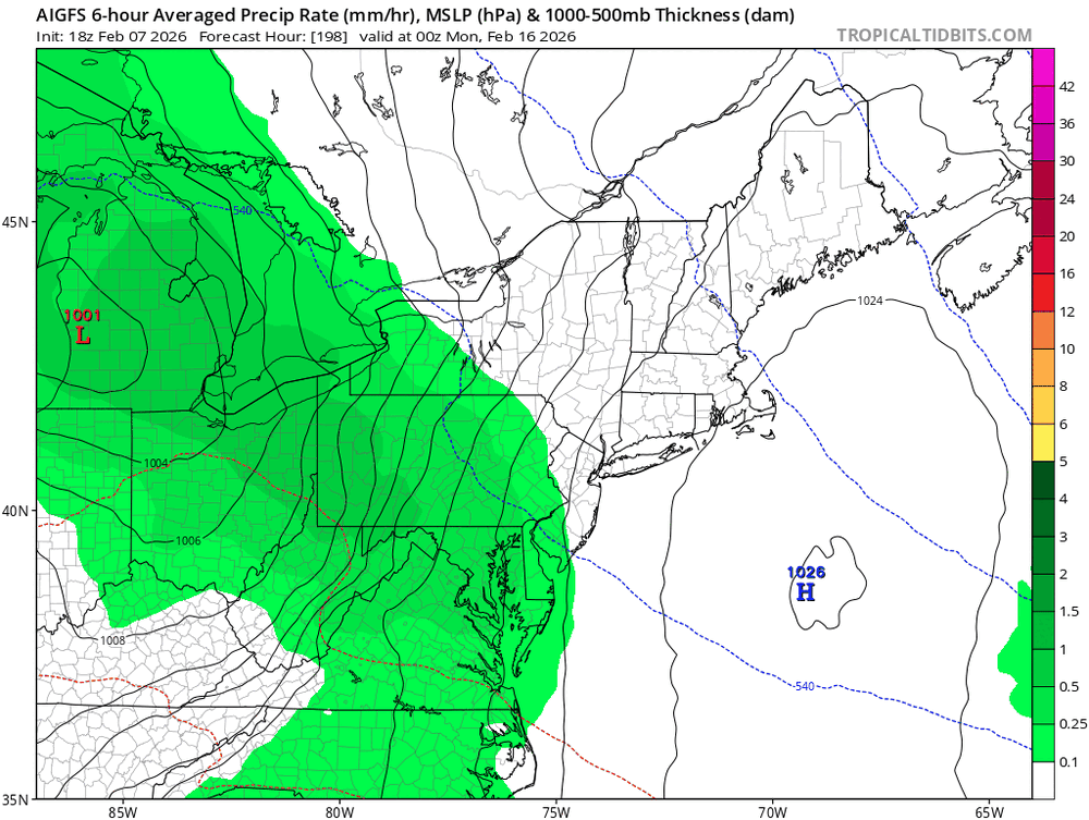
Rain to snow to snow (can’t tell without precip maps) on AIGFS
-
Good for you…you did well. Just had to believe a little.
-
5.5”
-

Friday February 6 FROPA / WINDEX small event
jculligan replied to HoarfrostHubb's topic in New England
5.9" total in North Salem NH. 18" settled snow depth. Seasonal total now stands at 48.0" which is officially the snowiest winter since I moved to this location in March 2022. That isn't saying much given our string of sub-par winters, but with essentially two months to go I feel good about my chances of finally surpassing the climatological norm for this location. Keep it coming! -

Friday February 6 FROPA / WINDEX small event
MuddyWx replied to HoarfrostHubb's topic in New England
7.5" final in Wakefield. My folks in BVY say ~14" -
One hit wonder
-
Next period to keep an eye on. PV on our side should be some colder air to work with.
-
For sure…what a clown. Just useless.
-

Friday February 6 FROPA / WINDEX small event
Baroclinic Zone replied to HoarfrostHubb's topic in New England
I don’t think you’re done yet -
 We'll be lucky if it's not south of South Carolina the way things have been going this year.
 -
Can you add? You’re getting dummer by the day. Spring is 6 weeks away fool.
-

Friday February 6 FROPA / WINDEX small event
DavisStraight replied to HoarfrostHubb's topic in New England
You got that much in NH? -
Friday February 6 FROPA / WINDEX small event
CarverWX replied to HoarfrostHubb's topic in New England
7 inches seems to be the final here -

E PA/NJ/DE Winter 2025-26 Obs/Discussion
penndotguy replied to LVblizzard's topic in Philadelphia Region
52mph wind gust here in Spring Twp Near Reading -
That visibility there is 1/4 to 3/8 mile so this is moderate to heavy snow that has been falling there for most of the afternoon.
-
Too bad we had the early morning high otherwise could've registered a sub 15 max. Seriously staying at 12-13F with sunny skies all afternoon is impressive. Forecast low is 2F but maybe a 0 is in the cards.
-

Friday February 6 FROPA / WINDEX small event
mahk_webstah replied to HoarfrostHubb's topic in New England
My measurement seems higher than most around here. I’m not sure why because I’m confident in what I measured. I am somewhere around 4.75 maybe 5 inches. -
Friday February 6 FROPA / WINDEX small event
snowdazed replied to HoarfrostHubb's topic in New England
Got nailed with about 8" here in Coventry. I wish this had happened when i could still enjoy days off from work.


