All Activity
- Past hour
-
Dont forget after those fails I chime in and state how much I loathe this hobby. Ji then cancels winter for the 22nd time, Weather53 says see I told you we are kicking the can again, mitch tells us he had a hunch January was toast, Terpeast says he has concerns for Feb being we are in a Nina but there is hope, Randy calls us nuts and tells Chuck to sybau, aldi22 says we are dumb, Maestrobjwa tells us hes learning new stuff every day, winter warlock replies to each post with 'lol' or 'lmao', then PSU posts a 3 page diatribe on how he hopes this isnt the new norm. Yeah, I think thats the usual pattern iirc.
-
I am not saying GEFS is right...hopefully we will be tracking a threat by the end of this weekend.
-
From a WPC met:
-
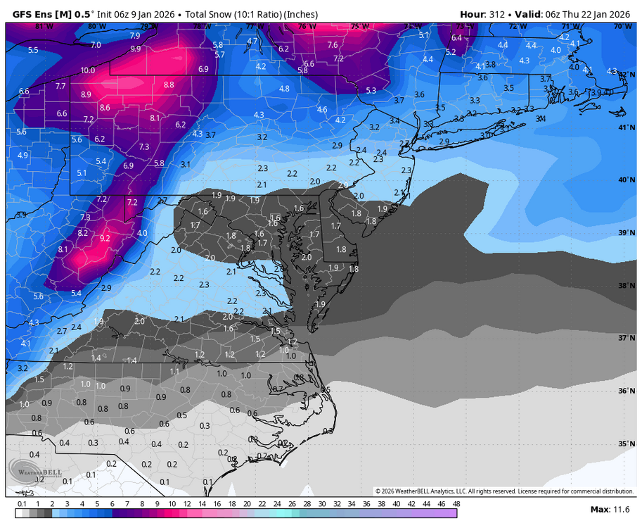
Yup! WB 6Z GEFS through Day 13 says it all:
-
Colder start to winter than recent years but not as cold as 17-18 was through January 8th. Time Series Summary for ISLIP-LI MACARTHUR AP, NY December 1st through January 8th Click column heading to sort ascending, click again to sort descending. 2026-01-08 34.1 0 2025-01-08 35.8 0 2024-01-08 40.7 0 2023-01-08 38.6 0 2022-01-08 40.3 0 2021-01-08 36.9 0 2020-01-08 37.3 0 2019-01-08 38.2 0 2018-01-08 30.3 0
-
More west/southern digging…trends I’m rooting for!
-

January 2026 regional war/obs/disco thread
WinterWolf replied to Baroclinic Zone's topic in New England
Pope, Also have to understand/take into consideration, what you’re seeing currently, may not be what actually may be happening 3-5 days from today. -
(002).thumb.png.6e3d9d46bca5fe41aab7a74871dd8af8.png)
Central PA Winter 25/26 Discussion and Obs
ChescoWx replied to MAG5035's topic in Upstate New York/Pennsylvania
Mild temperatures continue today with rain chances increasing this afternoon. A brief break in the rain tonight before we turn chillier with more rain tomorrow into Saturday night. Temperatures turn colder after Sunday with temperatures not too far from normal for mid-January before trending much colder by the end of next week into the weekend. We could see between 0.75” to 1” of rain tomorrow night. Winter weather opportunities start to ramp up by later next week.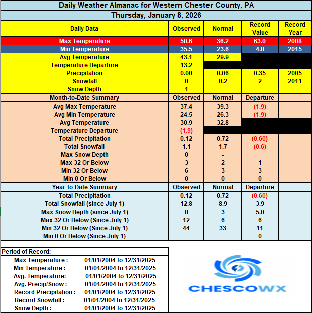

-
E PA/NJ/DE Winter 2025-26 Obs/Discussion
ChescoWx replied to LVblizzard's topic in Philadelphia Region
Mild temperatures continue today with rain chances increasing this afternoon. A brief break in the rain tonight before we turn chillier with more rain tomorrow into Saturday night. Temperatures turn colder after Sunday with temperatures not too far from normal for mid-January before trending much colder by the end of next week into the weekend. We could see between 0.75” to 1” of rain tomorrow night. Winter weather opportunities start to ramp up by later next week.
-
I had Ole Miss +3 1/2 points and they lost by 4, so I'd like a little snow to help cope with that please.
-
Significant increase in high tide or sunny day flooding across the areas in Florida which have experienced the greatest sea level rise. https://southeastfloridaclimatecompact.org/initiative/climate-indicators-high-tide-flooding/
-

January 2026 regional war/obs/disco thread
jbenedet replied to Baroclinic Zone's topic in New England
Looking at 6z EC AIFS - I don’t like it…. The early mid level cut-off in northern stream is another red flag. You’re going to get much more shunting east with the coastal than meridional mid level ridge development can compensate for over the western Atlantic. Maybe a cape scrape? I’m focusing on the 18th… -

January 2026 Medium/Long Range Discussion
North Balti Zen replied to snowfan's topic in Mid Atlantic
For the record - I recognize this from past winters. Two waves - people get invested in one, then the other, then a why not both hope sets in. It looks promising for one, then the other, then magically, a shift to a middle compromise with a massive storm. Hopes surge. Then, it starts to look muddy. PSUHoff weighs in to say that with better spacing it would be two nice events, but that unfortunately the worry is that they are too close together and interfere with the development of each. That ends up being right and we get flurries on Friday and gray skies on Sunday and see reports from the Carolinas of getting smoked in the first event and the Poconos in the second event. -

January 2026 Short/Medium Range Thread
Holston_River_Rambler replied to John1122's topic in Tennessee Valley
Does anyone know how to access ensemble H5 vort panels? Tomer Burg used to have that one Polarwx (I think), but can't find those particular panels any longer. -

Central PA Winter 25/26 Discussion and Obs
paweather replied to MAG5035's topic in Upstate New York/Pennsylvania
Hopefully I won’t need to chase somewhere else and can stay in Palmyra. -

January 2026 regional war/obs/disco thread
Damage In Tolland replied to Baroclinic Zone's topic in New England
I think the 15th storm is legit -

Central PA Winter 25/26 Discussion and Obs
pasnownut replied to MAG5035's topic in Upstate New York/Pennsylvania
I took advantage of the nice evening sans howling wind, and took christmas lights down last night as well as brought another load of wood down. Pattern looks loaded later next week and beyond. Trough axis hurtin us as best qpf well off shore, but IF we can get better spacing and less progressive w/ the flow, it might give something a chance to spin up a nice miller A. Going to be a lot of sorting out in the next few days, but it's fun to look at no matter the result. The chase is a big part of the fun for me. TGIF boys n girls. -

January 2026 regional war/obs/disco thread
Ginx snewx replied to Baroclinic Zone's topic in New England
Pretty obvious to me anyway but what do I know. All I now is one look and it was tent material -
January 2026 regional war/obs/disco thread
Ginx snewx replied to Baroclinic Zone's topic in New England
Spectacular looks. Ice castle like -
January 2026 regional war/obs/disco thread
Ginx snewx replied to Baroclinic Zone's topic in New England
Lol by the time I get to the map its bedtime j/k -

January 2026 regional war/obs/disco thread
dendrite replied to Baroclinic Zone's topic in New England
Not sure I agree. I think it’s in the process of tilting neg quickly. Did you loop it? I mean, I don’t doubt that it may end up a salad of interfering shit streaks, but I thought this run was ready to blow up.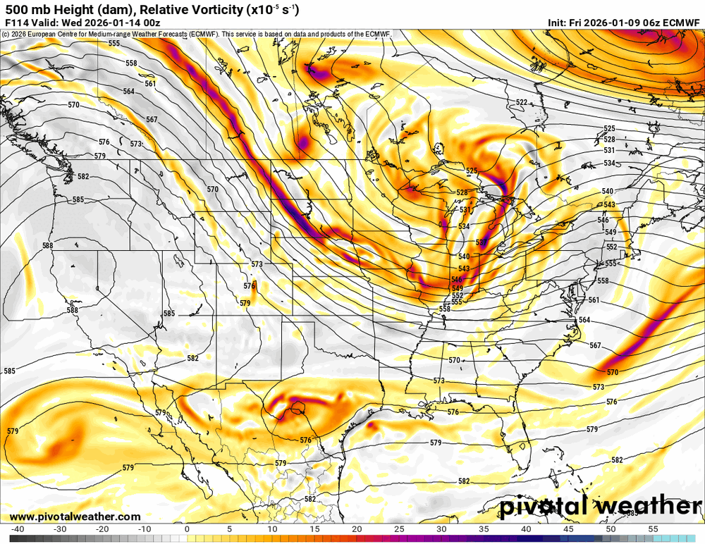
-
Warmup period so far SIte: High / low (dep) EWR: 1/6: 44 / 31 (+5) 1/7: 54 / 37 (+13) 1/8: 53 / 41 (+14) NYC: 1/6: 42 / 35 (+5) 1/7: 49 / 37 (+9) 1/8: 50 / 32 (+12)
-
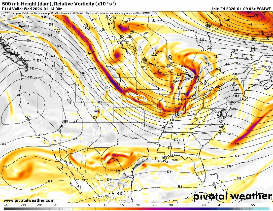
I think the thing that is peaking my interest the most are the 500mb maps. Go back and look at almost any major miller a we’ve had in the past. It looks almost identical.
-

January 2026 regional war/obs/disco thread
ineedsnow replied to Baroclinic Zone's topic in New England
driving around this morning and legit everywhere you look is postcard material.. all the trees are frosted and the sunrise was awesome.. -
January 2026 Short/Medium Range Thread
Holston_River_Rambler replied to John1122's topic in Tennessee Valley
Trend on the EPS is for more vorticity in the base of the trough: Would should be bale to have the EPS panels to go along with the GFS member panels covering the event by 18 or 0z tonight.