All Activity
- Past hour
-
I was eating 2 hamburgers.
-
Higher odds for AN January that’s for sure.
-
They are horrible and nothing suggests big warmth.
-

December 2025 regional war/obs/disco thread
WinterWolf replied to Torch Tiger's topic in New England
What was said was furnace All of January…I’m not buying that on 12/16…but that’s just me. -
Wait until today for another solution
- Yesterday
-
They weren’t all that bad last year and there’s a lot of factors why January could start hostile. I think many called for that.
-

December 2025 regional war/obs/disco thread
Ginx snewx replied to Torch Tiger's topic in New England
Ditto -
Analogs > Models
-
I think we’re def gonna have chances over the final 10 days of the month. It just will come with a lot of risk. There’s some weird blocking that’s been showing up too and the orientation of that will be a factor too. There aren’t a ton of analog patterns to that look. It’s kind of an unstable wave pattern there.
-

Central PA Winter 25/26 Discussion and Obs
Blizzard of 93 replied to MAG5035's topic in Upstate New York/Pennsylvania
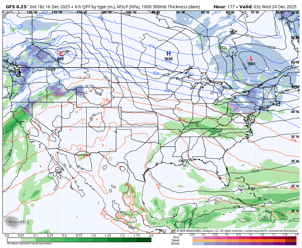
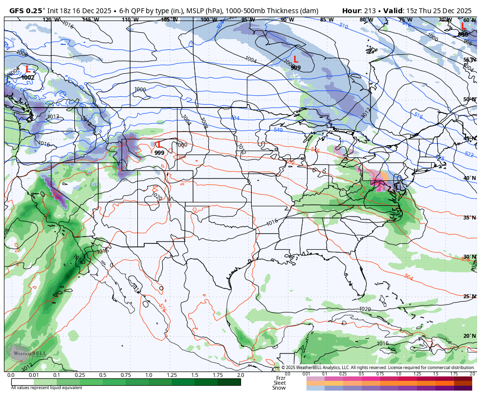
18z GFS is still trying to give us the chance of some light snow or mix with 2 wave potentials toward Christmas.
-
Yep, looking like a blow torch early January.
-

December 2025 regional war/obs/disco thread
Damage In Tolland replied to Torch Tiger's topic in New England
Wouldn’t it blow EmassWx winter forecast all up if winter ended next week? -
December 2025 regional war/obs/disco thread
WinterWolf replied to Torch Tiger's topic in New England
Week 3 plus…toss. They sucked ass last year. -
It kinda still is, looks like it warms as the evening goes on. At least in my area it’s gonna be 50 at midnight on the 25th into the 26th.
-
British Columbia with the mic drop lol

-
But I thought…
-
I’d be cautious about tossing it.
-
December 2025 regional war/obs/disco thread
WinterWolf replied to Torch Tiger's topic in New England
Off hour runs again…but hey, as TBlizz said the other day, it’s what it shows. -
December 2025 regional war/obs/disco thread
WinterWolf replied to Torch Tiger's topic in New England
Have to agree with you there…they were horrible last year. And anything past week 2 is a complete joke anyway imo..no matter what it shows. So, as of now, toss that January look is right. -
Temperatures will moderate for tomorrow through Friday. Thursday and Friday will be mild days with the mercury approaching or reaching 50° in parts of the region. A soaling rain is likely Thursday night and Friday. Much of the region could see a general 0.50"-1.50" of rain. Behind the storm, the weekend will turn somewhat cooler. The probability that December 2025 will have a maximum monthly temperature below 60° is increasing. The last time that happened was in 2019 when the monthly high was 58°. If 2025 has a monthly high below 60°, that would be only the fifth such occurrence since 2000 (2003, 2004, 2005, and 2019 are the cases since 2000). The ENSO Region 1+2 anomaly was -0.3°C and the Region 3.4 anomaly was -0.7°C for the week centered around December 10. For the past six weeks, the ENSO Region 1+2 anomaly has averaged -0.33°C and the ENSO Region 3.4 anomaly has averaged -0.67°C. La Niña conditions will likely continue through at least mid-winter. The SOI was -0.88 today. The preliminary Arctic Oscillation (AO) was +1.524 today. Based on sensitivity analysis applied to the latest guidance, there is an implied near 97% probability that New York City will have a cooler than normal December (1991-2020 normal). December will likely finish with a mean temperature near 34.3° (4.8° below normal). Supplemental Information: The projected mean would be 3.1° below the 1981-2010 normal monthly value.
-
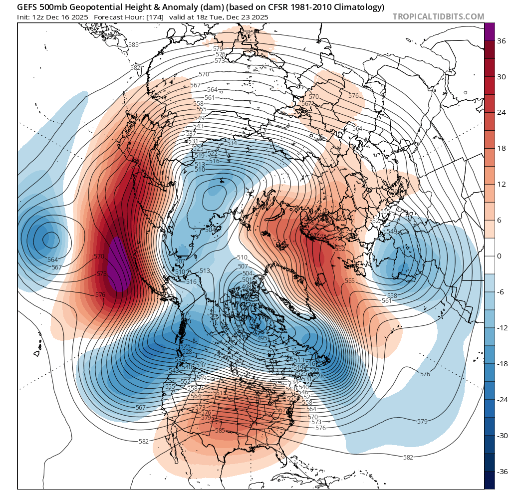
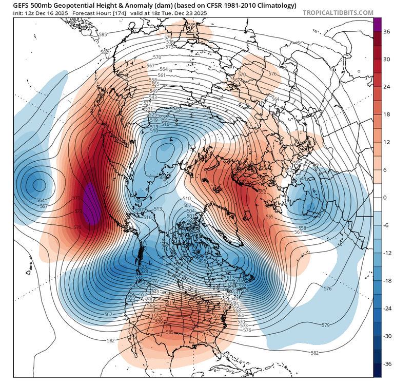
Not always that simple- Depends on the orientation of the ridge/trough combo. There was positively tilted ridge and a less meridional trough underneath allowing for a somewhat flat PNA ridge beneath that. Last couple weeks- As advertised going forward-
-
One way to look at it, sure is nice to have the cold air close by. Its seems like we haven't had that for years.....But on the flip side, that is a lot of warm air nearby as well. So yes, there will most likely be a lot of have and have nots moving forward. Hopefully since we have suffered for the past 4 years, hopefully this sets up somewhere in PA and we can all rejoice. But I as well as many know it doesn't work that way, soooo.....We watch
-

Winter 2025-26 Medium/Long Range Discussion
cyclone77 replied to michsnowfreak's topic in Lakes/Ohio Valley
That's a great pattern for the Donners @ Donner Pass. -

December 2025 Short/Medium Range Forecast Thread
Golf757075 replied to John1122's topic in Tennessee Valley
Carver, that's good news if true! Op runs and ensembles will show a colder outcome if it's legit. If not, it won't imo. -
The anomalously strong Aleutian ridge(+EPO/-WPO combo)/downstream deep trough along the west coast is the thorn in our side as advertised going forward, despite indications of a negative NAO developing. A positive sign on all the extended products is a shift in the NPAC pattern with a -EPO developing towards mid Jan, which could be the mechanism to deliver colder air into the central/eastern US going forward.