All Activity
- Past hour
-
At this point, I'd agree (not that it matters if I didn't lol.) North will be the place to be (as in you!), but my inland location down here should be worth at least a few front enders to mix. My old location just north of BWI was terrible for those type events, with changeovers always occurring ahead of schedule.
-

E PA/NJ/DE Summer 2025 Obs/Discussion
Kevin Reilly replied to Hurricane Agnes's topic in Philadelphia Region
Flash Drought!!!! Where's Drought Guy?? I may have cut the back yard for the last time this year. Yea, right we know what's next a Hurricane coming up from the Carolinas! -

2025 Spring/Summer Mountain Thread
WxKnurd replied to Maggie Valley Steve's topic in Southeastern States
No complaints, arrived Friday night. Been feeling amazing walking the dog in the mornings and I can walk to and from downtown which is a major change from living out in Upper Crabtree. Still lots to explore because it’s been something like 15 years since I’ve been out here, looking forward to the fast approaching Fall and shall see what winter holds. Weather station is up and running as of today. -
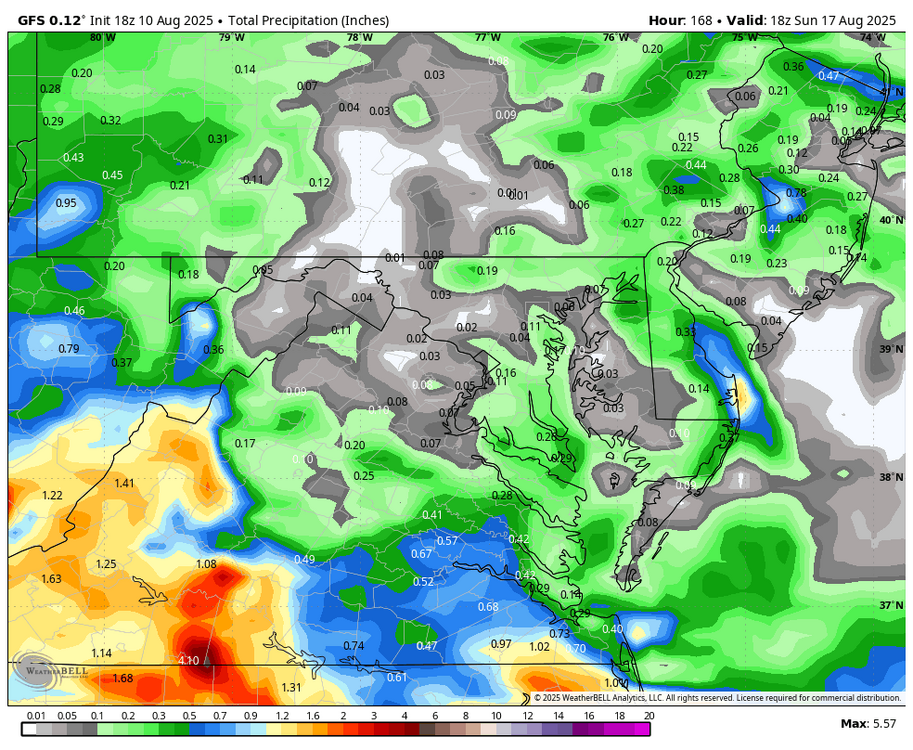
WB 18Z GFS. No rain next 7 days.
-
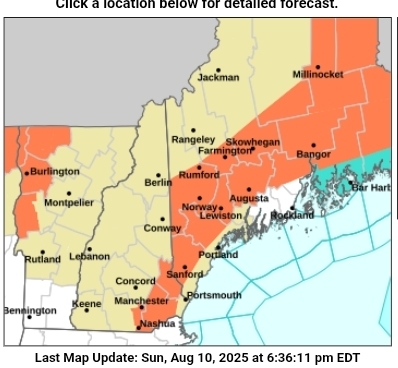
The Great Hot North. 92 in Manchester today.
-
I did. Still got a bogey but Joe the guy you played with got an eight so I didn't care
-
I think it part and parcel related to the quickly evolving flash Stein drought . Models always under estimate temps on dry ground , and strong sun( yes I know we’re out of the “super high sun angle” But it’s still a nadir
-
High of 91 here at home
-
yeah we will see, mother nature can be crazy, but this smells like one for the Fish.
-
Did you hit the green?
-
another very large hailstorm is somewhat close to the airport
-
12Z UKMET for the record: NEW TROPICAL CYCLONE FORECAST TO DEVELOP AFTER 60 HOURS FORECAST POSITION AT T+ 60 : 18.0N 39.9W LEAD CENTRAL MAXIMUM WIND VERIFYING TIME TIME POSITION PRESSURE (MB) SPEED (KNOTS) -------------- ---- -------- ------------- ------------- 0000UTC 13.08.2025 60 18.0N 39.9W 1009 30 1200UTC 13.08.2025 72 17.8N 43.8W 1008 26 0000UTC 14.08.2025 84 19.0N 46.2W 1009 30 1200UTC 14.08.2025 96 20.5N 50.1W 1009 30 0000UTC 15.08.2025 108 21.9N 53.0W 1008 32 1200UTC 15.08.2025 120 23.3N 55.9W 1006 36 0000UTC 16.08.2025 132 24.4N 57.9W 1005 43 1200UTC 16.08.2025 144 25.5N 59.8W 1004 46 0000UTC 17.08.2025 156 26.7N 60.8W 1002 48 1200UTC 17.08.2025 168 28.2N 61.2W 998 52
-
Yeah, it was weak Nina. Check out the N.Atlantic SST'S that Winter. Evident Nfd cold pool. Thanks for the Data dig John !
-
Neutral Neutral 1896 1898-1899 1901-1902 1905 1907-1908 1912-1914 1916 1920-1924 1927-1930 1932-1933 1935-1938 1940 1944-1949 1952-1954 1957 1959-1961 1963-1965 1967-1970 1972 1975 1977 1979 1981-1982 1984-1986 1990-1991 1993-1994 1996-1997 2001-2002 2004-2006 2009 2013-2015 2017-2020
-
El Nino years per PSL El Niño 1897 1900 1903 1906 1915 1919 1926 1931 1941 1942 1958 1966 1973 1978 1980 1983 1987 1988 1992 1995 1998 2003 2007 2010 2016
-
I found a CPC article about it that acknowledges it as a La Nina year. These are the La Nina years listed on the PSL/NOAA website. La Niña 1904 1909 1910 1911 1917 1918 1925 1934 1939 1943 1950 1951 1955 1956 1962 1971 1974 1976 1989 1999 2000 2008 2011 2012 2021 2022
-
Loving the temps but getting dry
-
We're looking at 4 or 5 days of 90 to 94 type heat wave which began today for many front yards and towns but will be more convincing tomorrow through Thursday. Euro agrees with your assessment thereafter with heat returning over the weekend. Too early for confidence but it even soars Monday the 18th to 101 at Lawrence, MA otherwise a lot of 99's at all typical sites on the day. Aug 18 isn''t too late for that sort of thing, but it is nearing the climate drop off.
- Today
-
From the fairway. Had to cross the same crap to get to that spot.
-
If you don’t want a US hit then you want the TC to form as early as possible as stonger storms tend to be pulled poleward quicker.
-

2025-2026 ENSO
40/70 Benchmark replied to 40/70 Benchmark's topic in Weather Forecasting and Discussion
Its going be a weak La Nina....not prohibitive to east coast winter, but nor do I expect a primary storm track over the benchmark. Going to me a blend of messy storms and redevelopers IMO. -
2025-2026 ENSO
40/70 Benchmark replied to 40/70 Benchmark's topic in Weather Forecasting and Discussion
ENSO should be a bit weaker than last year, but I don't think it will make much of a diff. As for analogs, take a look at my new blog post with respect to the higher latitudes. I haven't done the Pacific yet....probably towards the end of the month. -
My yard runs moist, but it’s even starting to get dire here

-
It’s a small contingent fortunately.