All Activity
- Past hour
-
 Anvin667 joined the community
 - Today
-

2025 Atlantic Hurricane Season
WxWatcher007 replied to BarryStantonGBP's topic in Tropical Headquarters
I don’t think we’re going back yet. The last few years have been so incredibly warm in the basin that it almost had to pull back once we moved away from the recent ENSO regime. As for this season…the SSTA in the tropical Atlantic and subtropics kind of scream stability issues but it’s early still. I’d like to see how waves fare as they come off Africa more continuously. -
Steady light rain has developed in the 25 min... Nothing major in the rain so far..... But significant occasional redish lightning with long lasting rolling thunder has developed...
-
Updated evening AFD from LWX explains reasons for the watch SHORT TERM /MIDNIGHT TONIGHT THROUGH MONDAY NIGHT/... Evening update: The main forecast change this evening was the issuance of a Flood Watch for flash flooding for portions of the Alleghenies, Potomac Highlands, Shenandoah Valley and Central Virginia from 7 AM to 10 PM tomorrow. Within this corridor, flash flood guidance is very low due to saturated soils and high background streamflow levels following recent rains. East to southeasterly 850 hPa flow to the north of the surface front will also intersect the Blue Ridge and Alleghenies, potentially leading to orographic enhancement of rainfall. A widespread 1 to 2 inches of rainfall is expected across this area, with localized totals up to 5 inches possible. This rain will likely be spread across multiple rounds of showers and thunderstorms late tonight through tomorrow evening. For now, the Watch is in effect where wet antecedent conditions and potential terrain enhancements resulted in greater confidence regarding flash flooding potential. The Watch may possibly need to be expanded along the edges at a later time, but decisions for those surrounding areas were deferred to subsequent shifts due to uncertainty in the northeastward extent of the heavier rains and/or higher flash flood guidance values.
-
Flood Watch National Weather Service Baltimore MD/Washington DC 757 PM EDT Sat Jun 7 2025 MDZ501-509-510-VAZ026>030-037>040-507-WVZ050-055-501>506-080800- /O.NEW.KLWX.FA.A.0009.250608T1100Z-250609T0200Z/ /00000.0.ER.000000T0000Z.000000T0000Z.000000T0000Z.OO/ Extreme Western Allegany-Western Garrett-Eastern Garrett- Rockingham-Shenandoah-Frederick VA-Page-Warren-Albemarle-Greene- Madison-Rappahannock-Northern Virginia Blue Ridge-Hampshire-Hardy- Western Grant-Eastern Grant-Western Mineral-Eastern Mineral- Western Pendleton-Eastern Pendleton- 757 PM EDT Sat Jun 7 2025 ...FLOOD WATCH IN EFFECT FROM 7 AM EDT SUNDAY THROUGH SUNDAY EVENING... * WHAT...Flash flooding caused by excessive rainfall is possible. * WHERE...Portions of western Maryland, including the following areas, Eastern Garrett, Extreme Western Allegany and Western Garrett, Virginia, including the following areas, Albemarle, Frederick VA, Greene, Madison, Northern Virginia Blue Ridge, Page, Rappahannock, Rockingham, Shenandoah and Warren, and eastern West Virginia, including the following areas, Eastern Grant, Eastern Mineral, Eastern Pendleton, Hampshire, Hardy, Western Grant, Western Mineral and Western Pendleton. * WHEN...From 7 AM EDT Sunday through Sunday evening. * IMPACTS...Excessive runoff may result in flooding of rivers, creeks, streams, and other low-lying and flood-prone locations. * ADDITIONAL DETAILS... - -Multiple rounds of showers and thunderstorms are expected on Sunday as an area of low pressure tracks eastward and interacts with a frontal zone. A widespread 1 to 2 inches of rainfall appears likely, with localized totals up to around 5 inches possible. Saturated soils and background high streamflow levels may enhance the threat for flooding. - Please visit www.weather.gov/safety/flood for flood safety and preparedness information PRECAUTIONARY/PREPAREDNESS ACTIONS... You should monitor later forecasts and be prepared to take action should Flash Flood Warnings be issued.
-
I want the rain. It’s been a long week with a wedding and retirement celebrations. Worked all day at the brewery so a dark day inside is what I’d enjoy most. But that’s rare in June so I’m expect partly sunny and passing showers and storms.
-
If that’s a block, f mlb.
-
.08" here
-
Yikes. We drove from BGR TO PQI and didn’t see anything other than sprinkles. I don’t think it rained here at all after we arrived around 12:30.
-
This is what we saw.
-
After watching Charlie Morton throwing 76 pitches to get 7 outs, I am fine with never watching him pitch again.
-
Os are so pathetic. That first inning is like a microcosm of the entire season. Elias has fucked up this roster so bad.
-
BC built a new softball/baseball complex behind the Seminary on Lake St a few years ago. Really nice fields too as they just hosted the ACC Softball championship. The softball program isn't that great, but they try hard and it's a fun watch for an impressionable 10u player. We're supposed to play at Cold Spring Sunday, but that field takes a while to dry out, so we'll see. Oh yeah back on topic. 64* with clear skies and it's less humid out. Didn't seem smoky around the moon, but we'll see tomorrow?
-

2025 Lawns & Gardens Thread. Making Lawns Great Again
tunafish replied to Damage In Tolland's topic in New England
I did last year. Ineffective against both moles and groundhogs, ha. -
High of 92. Picked up 1.21" total from 2 storms today.
-
Alot of rain seems to have fallen south of 64 the last 24 hours , southern Augusta / Stuarts Draft into Rockbridge.. Which seems to be the convective pattern down here the last 3 years - hence the crushing spring - mid summer Valley droughts the last couple years have been Waynesboro northward.... .09 last 24 hours here... Another cluster just popped in the same area... Thankfully the large synoptic events this spring have been a nice change...
-
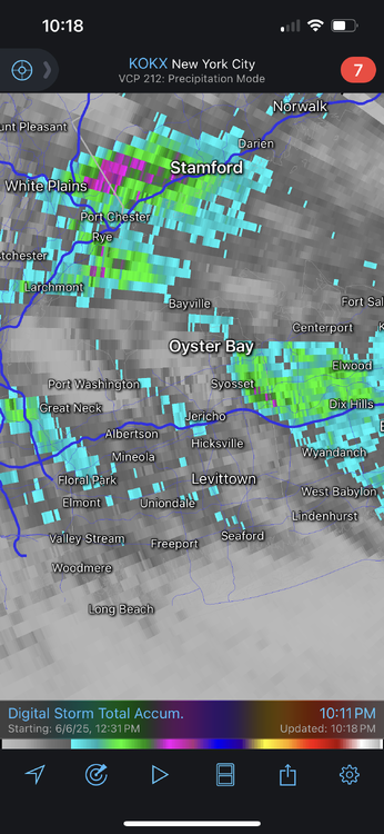
From RadarScope. Darker gray is 0.5-1”, Blue is roughly 1”+, green is 1.5”+. The purple dots are 2”.
-

June 2025 discussion-obs: Summerlike
LongBeachSurfFreak replied to wdrag's topic in New York City Metro
Was just going to ask the same. Had to have been close to an inch here in SW Nassua that fell in less then 30min -
Yeah it was light here until that brief downpour
-
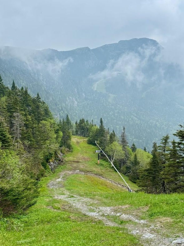
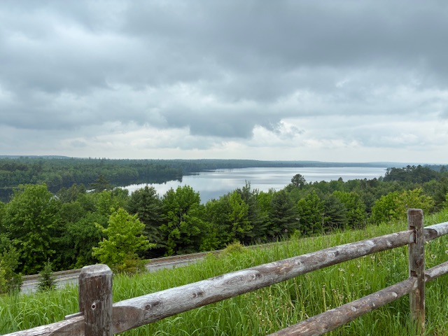
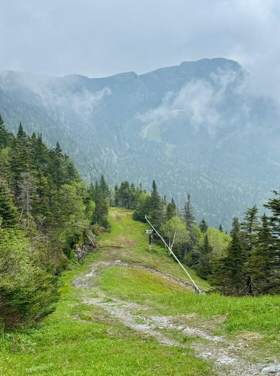
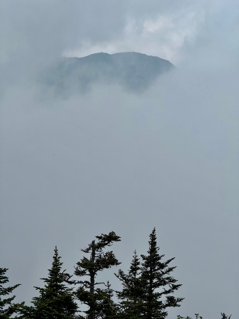
It was a smoky blue tint hazy day. There were some clouds around the mountain, but the view was smoggy. The Mansfield ridgeline is 2 miles long from above where I'm standing to the high spot across there, and even that view was hazy. The 5-6 mile visibility seemed about right. Eventually the clouds filled in.
-
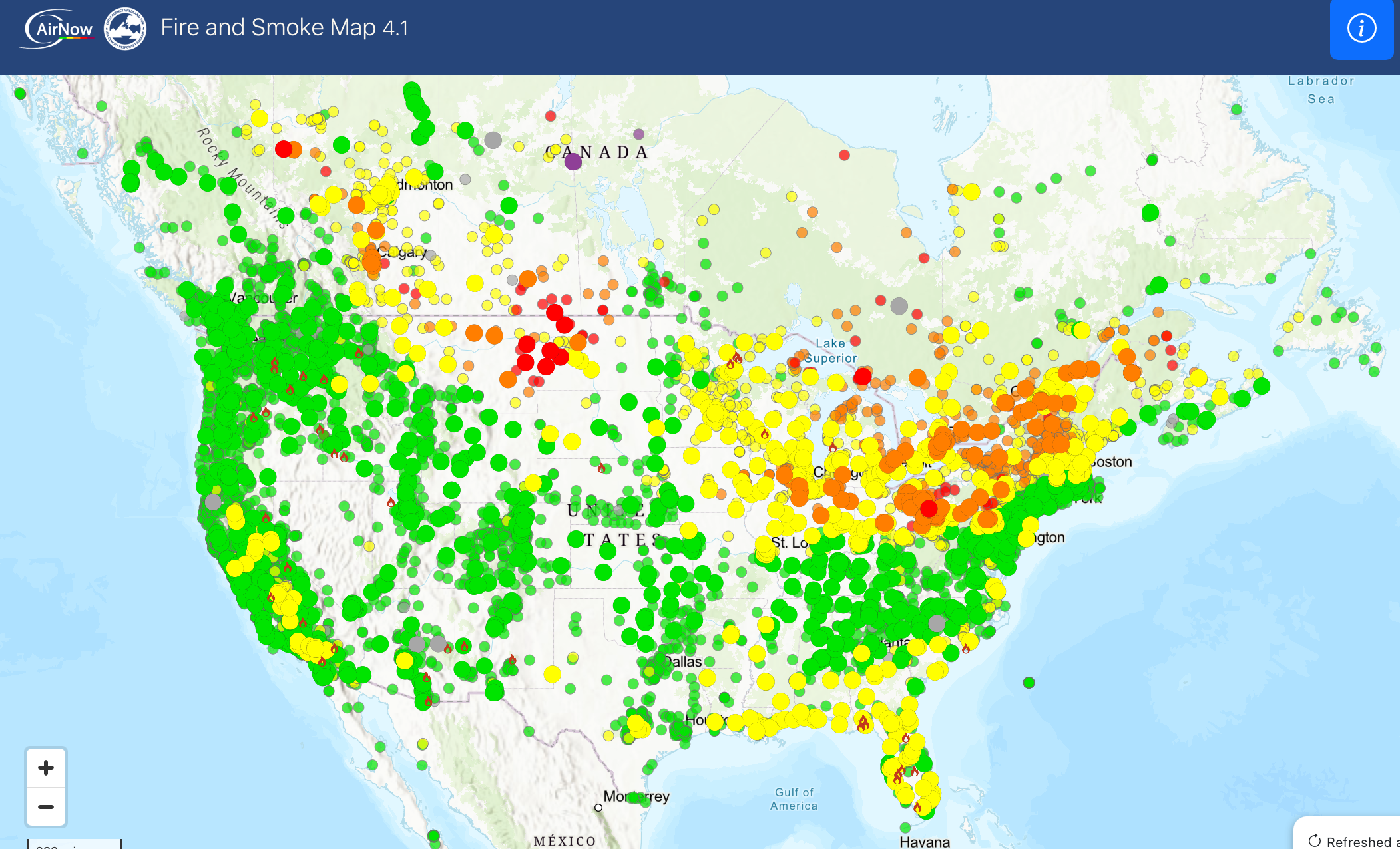
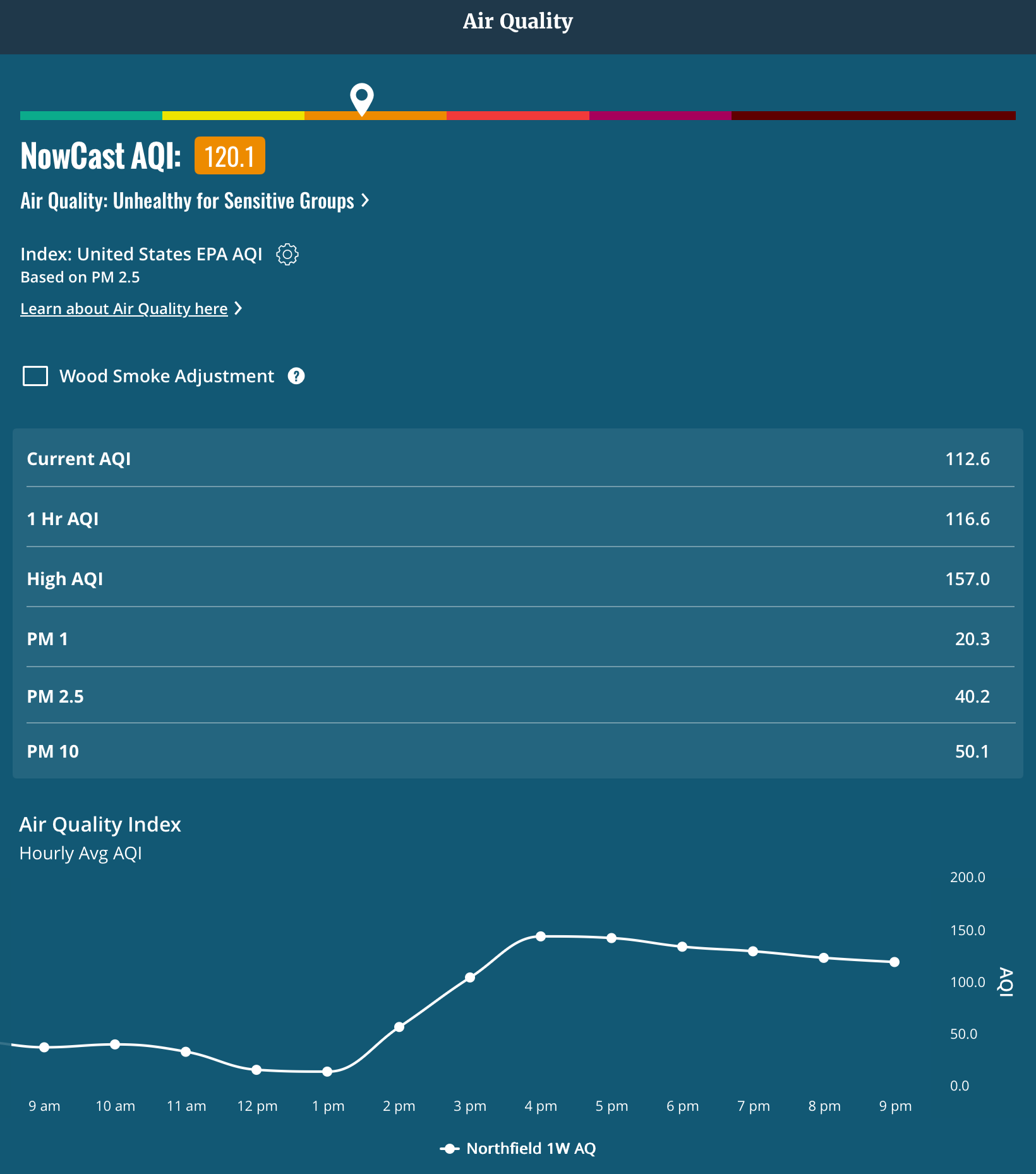
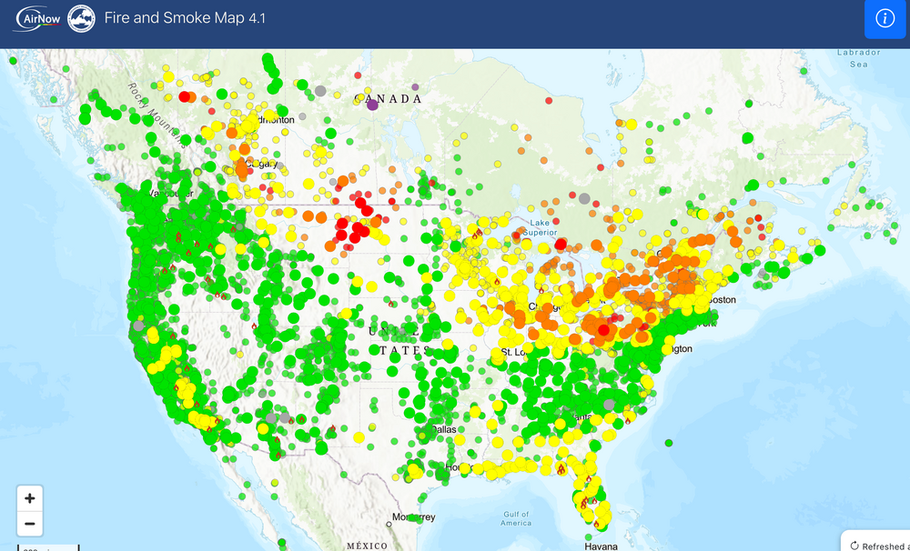
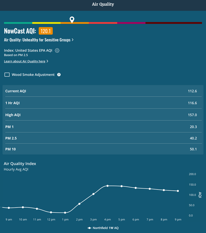
AQI clown map. Let’s pump those numbers up. It’s been pretty high here on my sensor as well.
-
1.20” of rain here. The drive back from basketball was wet, lots of flooding on area roads.
-
Days and days of steamy pavement, smoke, and moist plumbers cracks..ya love to see it!
-
We are firmly in splotchy season now.
-
The early season modeling that predicted the worse of the heat being out West is holding true in the very early phase of JJA. Seems that the High pressure tendencies that started many summers ago is present again Northeast of us allowing a more humid airmass, but not extreme heat. Temps may be skewed by higher overnight lows.
-
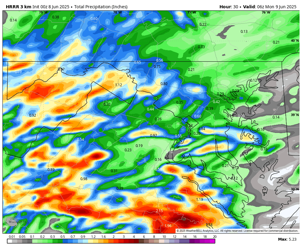
WB 0Z HRRR for Sunday.