All Activity
- Past hour
-
Yep-there’s a reason why we always have “bad luck” or shortwaves interfering with storm setups and amplification. The flow is too zonal/fast so we have interference all the time from competing s/w and the ridge placement/amplification out west is always off-ridge is too flat or pushed out of place. Maybe one day we can get “lucky” even in this pattern and we won’t have to deal with all this interference, but to me it just seems very hostile to getting any larger snow system around the city than a small 1-2” type clipper like we had last December. Once the ridge out west amplifies, we can get some real blocking and the SE ridge stays muted we can talk about something bigger.
-
Statistical tidbit from 1990-91 through 2024-25: 14/15 (93%) of winters with above normal seasonal snowfall had a least one day with 8" or more snow (72% prior to 1990-91) 17/18 (94%) of winters with below normal seasonal snowfall did not have any 8" or above daily amounts (75% prior to 1990-91) 14/17 (82%) of winters with at least one day with 8" or above snowfall had above normal seasonal snowfall (63% prior to 1990-91) 2014-15 with 50.3" seasonal snowfall was the lone exception for seasons with above normal snowfall with a maximum daily amount of 7.5" since 1990-91. This data suggests that in the contemporary warmer climate, a big snowstorm has become relatively more important to seasonal snowfall outcomes than in the past. Both subsets are longer than 30 seasons in length suggesting that the difference provides some insight. Moreover, this is what would be expected in a warmer climate with somewhat fewer snowy days.
-

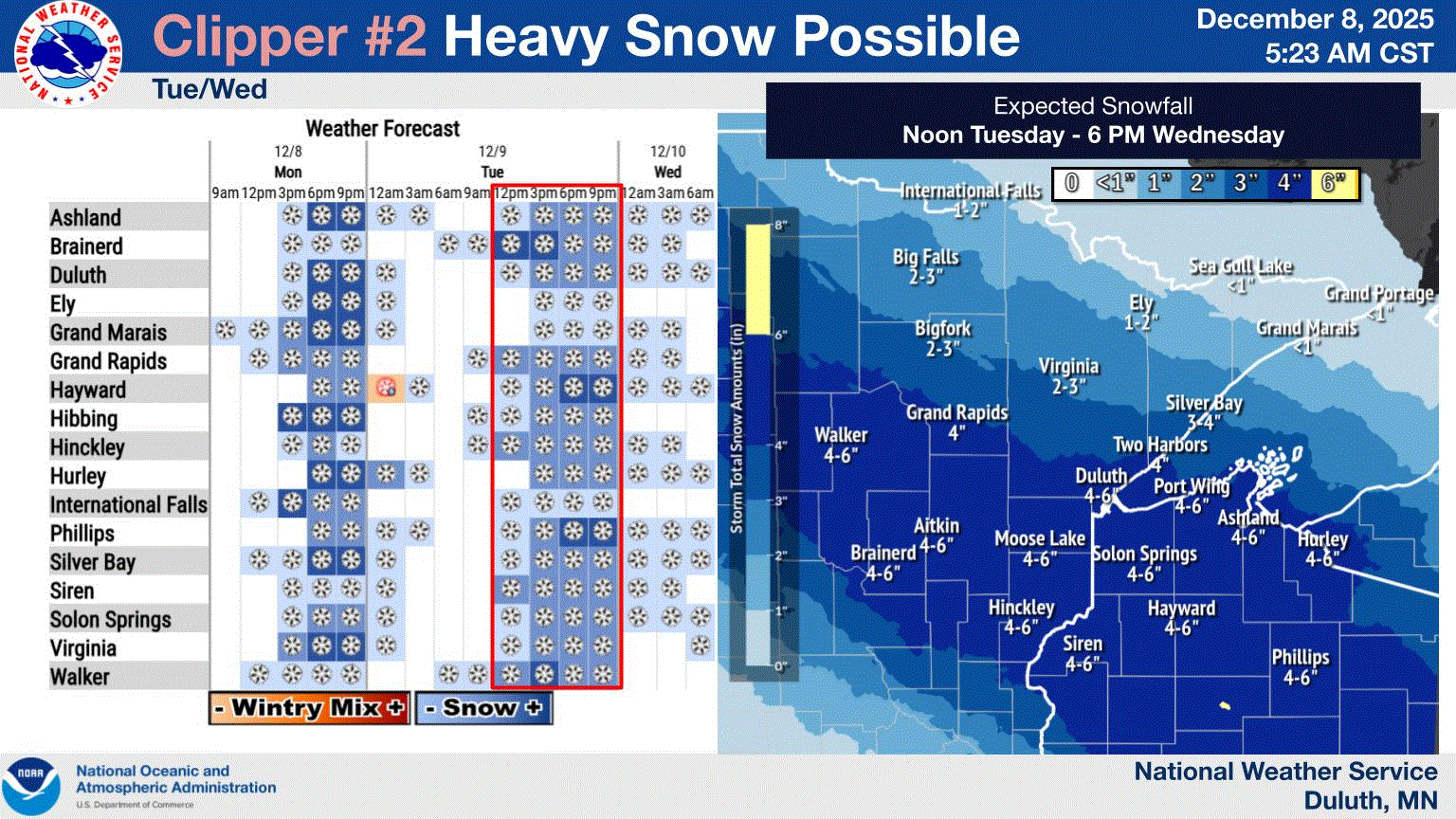
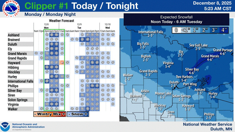
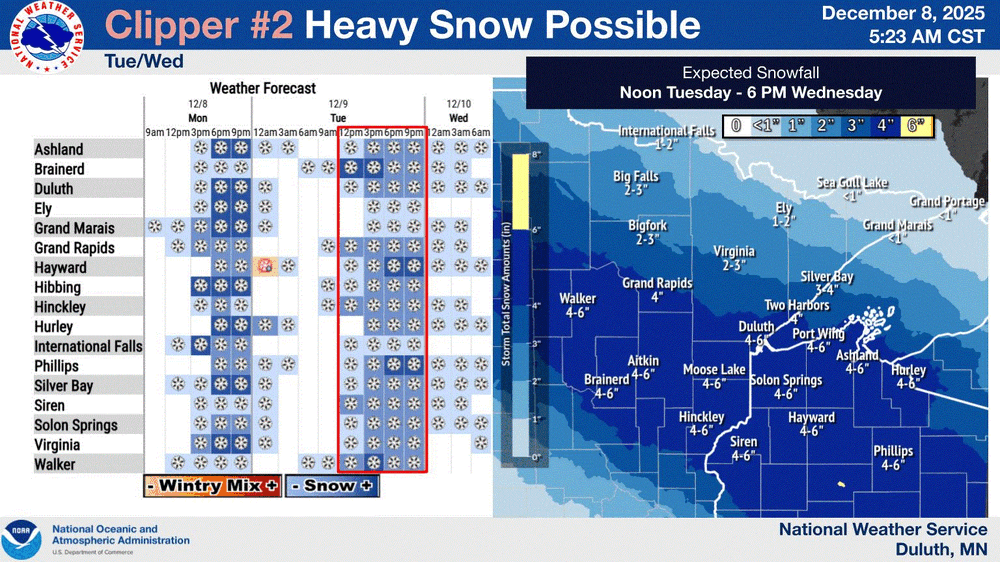
The Monday wintry event potential (12/8/25)
WinstonSalemArlington replied to GaWx's topic in Southeastern States
-

Richmond Metro/Hampton Roads Area Discussion
Conway7305 replied to RIC Airport's topic in Mid Atlantic
Finally sticking to Grass in Henrico. -
You and your weenies. I must say, you are the most disrespectful individual on this board.
-
Related to this is the -PNA Dec to +PNA Jan transitions for -ENSO that have been happening during the last 40 year period. That transition has been strongest when the Dec -PNA was strongest. Examples of cold Jans were during these winters: 1983-4, 1984-5, 2008-9, 2010-1, 2013-4, and 2021-2 where Jan is cold though not always colder than Dec.
-
The Monday wintry event potential (12/8/25)
WinstonSalemArlington replied to GaWx's topic in Southeastern States
Snowing in Winston-Salem -
12Z Icon has the Fri/Sat thing. Looks good for NOVA and north. Ninja'd
-
I miss my house up in Ashe County on days like today. I had good elevation in the area I was in and also cashed in being closer to VA sometimes. I might have to go land hunting soon and build another one.
-

December 2025 regional war/obs/disco thread
WinterWolf replied to Torch Tiger's topic in New England
Lol…she’s just a fool. But we laugh. Let’s get system in here, and join the party. Frieken cold out there today. -
Icon hoped on board with Friday/Saturday
.thumb.png.1ee3efca8c538f850f1b9db036a20e66.png)
-

The Monday wintry event potential (12/8/25)
PackGrad05 replied to GaWx's topic in Southeastern States
41 in Willow Springs on my Tempest. Latest HRRR looks better. -
Traffic cams show it really coming down on I-64 northwest of Richmond, just past Gum Springs. As you get closer to Richmond, some flakes are starting to show on the cams in places like Short Pump.
-

The Monday wintry event potential (12/8/25)
NorthHillsWx replied to GaWx's topic in Southeastern States
Front has come through. Getting some strong N gusts. Temp has risen to nearly 40 though -

The Monday wintry event potential (12/8/25)
kvegas-wx replied to GaWx's topic in Southeastern States
Ground covered in Stuart VA at the farm and now snowing nicely in Kernersville. No more mix. -
Currently 22 here (10:30 a.m.) with some scattered flurries between 8 and 8:30. Currently mid to upper teens NW Sussex County ice box spots as cold air continues to spill in behind the front.
-

December 2025 regional war/obs/disco thread
RUNNAWAYICEBERG replied to Torch Tiger's topic in New England
Mention her name and the resident predator goes wild. -
Is this because we stopped getting smaller storms or because some of the same storms got bigger? More of a rhetorical question because I have no idea how one could answer it. Is there a way to look at annual snowfall totals net of NESIS storms?
-
Congratulations, get all you can, love snow
-
The Monday wintry event potential (12/8/25)
NorthHillsWx replied to GaWx's topic in Southeastern States
Snow globe -
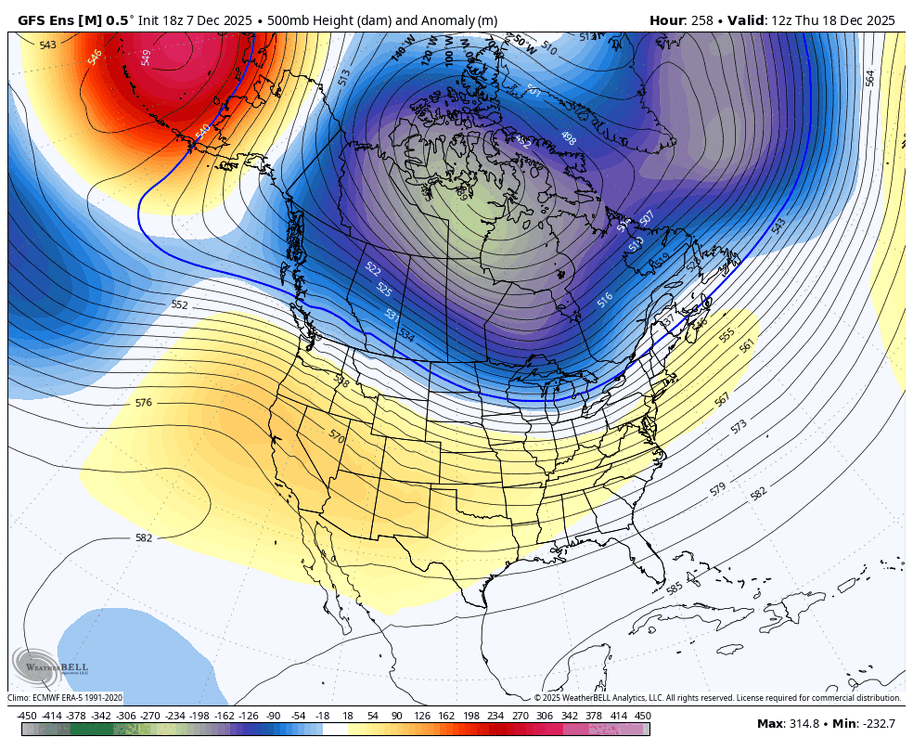
Indeed, and look at the trend of just the last 3 GEFS for 12Z on 12/18: E trough deepening/W ridge strengthening. It’s important to keep watching these trends as the models in general have been much too warm in the E US since the runs starting 3 weeks ago:
-

Richmond Metro/Hampton Roads Area Discussion
iherebyresign replied to RIC Airport's topic in Mid Atlantic
Stuck at 33.9 in Mechanicsville with no sticking to any surfaces. Probably already wasted a good half an inch -
End of the HRRR run looks like it gets the coastal cranking earlier which enhances precip back towards Richmond later today. Maybe a trend to watch.
-
Your generalizations are a figment of your imagination. You need to supply proof.
-
-sd's/10's this morning with sd's along the shore. Looks like 24-36hrs of light/mod snow my way. 6-8" total accum forecasted for TH.


.png.380792e11681274313736a621adcec07.png)