All Activity
- Past hour
-

2026-2027 Super El Nino
snowman19 replied to Stormchaserchuck1's topic in Weather Forecasting and Discussion
The thermocline is about to deepen (drop) big time in the eastern tropical PAC. This very strongly supports this event staying east-based/East Pacific -
finally some action soon
-
77 / 68 sunny. Warm but about 7 - 9 degrees cooler than yesterday for most. Onshore flow Mon - Tue drops it back cooler upper 70s to low 80s. Wed moderating warmer. Looks like a classic Hazy - Hot - Humid and potential for daily tstorms Thu - Sun, temps could push record levels in areas. Beyond there some moderation but overall wamer with bouts of heat with ridge on both coastal corners and likely storm chances. 6/7 - 6/9 : Near normal cooler Monday 6/10 -6/14 : Hot , Storms peak heat Thu - Sun 6/15 - beyond : Overall warmer - storms chances
-
Are you the same guy that has been complaining about not being able to get your Saturday game in without being rained on?
-
2026-2027 Super El Nino
snowman19 replied to Stormchaserchuck1's topic in Weather Forecasting and Discussion
“No surprises in the latest NMME climate model output. Niño intensity has ticked up in a few of the models (the CanESM5 was one of the last moderate Niño holdouts last month but it's all in on a near-record event now). I think the NCAR CESM1 broke or something this month. The response looks extremely classic too. Wet anomalies across the tropical Pacific, with the NE and Central Pacific also active thanks to the +PMM. The Atlantic will be dry and hostile for basically the whole season, with drought possible in the Caribbean. The Gulf Coast will likely have a wet and stormy winter as the subtropical jet gets cranking.” -
Pollen is so bad. About to hose off my truck, porch, driveway and kids swing
-
Thanks. The 0Z EPS cut back significantly on the % of members with Gulf TCG vs yesterday’s 12Z run. It will be interesting to see how future runs compare.
-
Yeah the wind really picked up in the last half hour. 69/60 Feels chilly!
-
Today's update cut back those numbers quite a bit.
-
Yesterday’s 12Z EPS had nearly 50% of its members with a TCG in S Gulf/NW Car late next week with most of those then heading to the U.S. Gulf coast the following week. However, the 0Z EPS cut back significantly on the % of members with Gulf TCG vs yesterday’s 12Z run. It will be interesting to see how future runs compare.
-
Dewlicious
-
We retreated to coast and it’s been beautiful here all weekend. Sea breeze and 80
-
.6
-
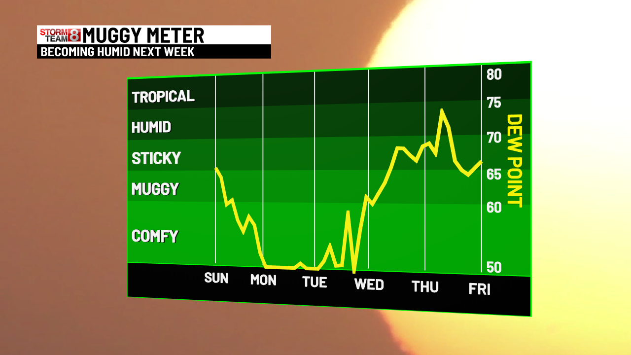
Let's not forget about the dews...

-
Days and days of 90s coming up. Cant wait.
-
It lasts a few days. Summer is the best season. Winter is slowly dying. We summer. We hop on the bandwagon.
-
Wind? Some big boomers down there.
-
Nice light show snd thunder last night knocked out power. 0.44" Sent from my SM-S921U using Tapatalk
-
Ya the pollen is bad now.. even had to use my windshield washer fluid this morning before leaving.. but everyone just loves summer
-
The NJ warm spots away from the sea breeze are tied for the most 90° days by June 6th. Time Series Summary for SOMERSET AIRPORT, NJ Click column heading to sort ascending, click again to sort descending. 1 2026-06-06 6 0 - 2021-06-06 6 1 2 2023-06-06 4 0 - 2000-06-06 4 13 5 2022-06-06 3 0 Time Series Summary for HARRISON, NJ Click column heading to sort ascending, click again to sort descending. 1 2026-06-06 8 1 2 2018-06-06 7 0 - 2010-06-06 7 15 3 2021-06-06 5 0 - 2013-06-06 5 0 - 2002-06-06 5 5 - 2001-06-06 5 7 Time Series Summary for NEWARK LIBERTY INTL AP, NJ Click column heading to sort ascending, click again to sort descending. 1 2026-06-06 8 0 - 1991-06-06 8 0 - 1986-06-06 8 0 2 2010-06-06 7 0 3 2021-06-06 6 0 - 2002-06-06 6 0 - 1936-06-06 6 0
- Today
-
NAM tries to bring a few storms across our region this afternoon. Looks like slim pickings but it's a chance.
-
A busy hazards week across the country
-
74F/ gusty, pollen everywhere......
-

Central PA Summer 2026 Discussion/Obs Thread
mahantango#1 replied to Voyager's topic in Upstate New York/Pennsylvania
-
Another round of 90 degree days on the way later this week - does anyone have stats on the record number of 90 degree days anywhere in the metro prior to the official first day of summer for a given year ?