All Activity
- Past hour
-

Extreme Cold, Snow & Sleet: SECS 1/24 - 1/26
NJwx85 replied to TriPol's topic in New York City Metro
01z HRRR 1hr snowfall rates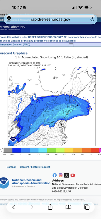
-
 We don't spike until the ruler is covered!
 -

January 24-26: Miracle or Mirage OBS Thread!
Snowciopathic Snow Bro replied to Jebman's topic in Mid Atlantic
Waiting in Gainesville. No snow sticking to data centers yet. In the meantime, let's take one last look at the models in order: Euro, CMC, GFS, and NAM:
-
Had 2 plus hours of that when it started here.
-
I'm the best met in town. You should wake up at 4-5 AM. Get some sleep while you can right now.
-
Visibility down to about 1.5 miles. Light Snow, 15/8
-

January 24-26: Miracle or Mirage OBS Thread!
nw baltimore wx replied to Jebman's topic in Mid Atlantic
No. Sorry, bro. We know your microclimate. You can only tell us that it isn't snowing over your house. -
I picture you more like this (except it’s snowing out)

-

MO/KS/AR/OK 2025-2026 Winter Discussion
MoWeatherguy replied to stormdragonwx's topic in Central/Western States
Anybody else see this from NWS TUL? Sounds like this might continue to be a sleet parade south of I 44 most of the night. .SHORT TERM... (The rest of tonight) Issued at 805 PM CST Sat Jan 24 2026 Analysis of water vapor imagery reveals a robust upper level low entering Texas this evening. The GLM shows numerous cloud flashes in the convection wrapping around this low, which will later eject northeastward into the forecast area as its absorbed into the main upper level trough. In the meantime, confluent mid level flow at 700 hPa is supporting frontogenesis to the west of the forecast area. Widespread upper level diffluence and increase potential vorticity advection is also noted. Cooling cloud tops and expanding precipitation within the frontogenetical zone are already occurring. Meanwhile, fairly deep moisture continues to stream into the area from the south ahead of the upper level low. These factors should support a consolidation of the numerous showers into a broad precipitation shield with embedded areas of convection. Widespread moderate to locally heavy precipitation will develop through the early overnight hours before gradually diminishing during the day Sunday. Snow will be favored along the I-44 corridor, with a mixture of snow and sleet down to just south of the I-44 corridor, and sleet to the south of there. Total snow and sleet will be highly variable but significant. The hardest hit areas could see up to 10 inches of snow or 2 inches of sleet, though most will see somewhat lower totals. -

January 24-26: Miracle or Mirage OBS Thread!
SnowenOutThere replied to Jebman's topic in Mid Atlantic
Doing my first jebwalk rn to get pictures. Any Mets or psu want to weigh in on when to set my alarm overnight to make sure I get up and have an hour before the sleet line? -

“Cory’s in LA! Let’s MECS!” Jan. 24-26 Disco
40/70 Benchmark replied to TheSnowman's topic in New England
Actually, I do vaguely remember the neighbor using the snowblower in the Feb 1983 megalopolis storm, too. -
Don't do this to me man
-
I think it really is diamond dust. All the road surfaces are completely white now, from the "snowfall", not from sleet accumulation and not like an ice glaze.
-
I wasnt expecting anything more than flurries before midnight. I'll wait until then to throw a tantrum...(Not here...in some group chats!) The column is saturating - fairly quickly based on the dew points. All good!
-

Pittsburgh/Western PA WINTER ‘25/‘26
Mailman replied to Burghblizz's topic in Upstate New York/Pennsylvania
I hear that it's snowing in Seven Springs. -
What we call a north trend
-
Starting to get hype in here! Snow is in the doorstep
-
Yall remember this? I went back to what seems like 17 years ago to the first thread I made about this storm and found this.
-
Trying to be positive. Trying SO HARD haha. I think we're good for at least 6. Maybe a surprise can get us to a 10am switchover and 8"
-
Me after the recent model runs and waiting for years.
-
“Cory’s in LA! Let’s MECS!” Jan. 24-26 Disco
40/70 Benchmark replied to TheSnowman's topic in New England
Right, but it's consecutive runs.....I don't think it's going to make a difference, but it is what it is. -
January 24-26: Miracle or Mirage OBS Thread!
nw baltimore wx replied to Jebman's topic in Mid Atlantic

-
Hamden F4 in July '89 is mine. First snow would be Thanksgiving that year, but the buildup to March '93 still holds a special space. Still remember the Weather Channel accumulation map with the bright white 1'+ demarcation stretched from Georgia to Maine and a little note that said "locally 3'+".
-
Every storm is different and this is not scientific at all but I do think there is something to this… A couple days ago I said I liked the wedge presentation in the mid levels over 2007 and 2017, examples when the mid level warmer won quick in a route. When there is a clear southward wedge into VA even in the mid levels and the mix comes at us from the southeast not due south or worse southwest we bang on way way longer. IMO it’s indicative of a deeper cold layer that’s fighting more in the mid levels. Often when we bust high on snow in changeover situations it was when the mix was trying to advance SE to NW into the CAD wedge. Unfortunately the guidance has shifted toward a more straight south to north look to the mid level warmth. Unfortunately it’s been my experience that when the mid levels are advancing uniformly through the cold wedge that way it indicates less resistance to the WAA. The one thing that could offset this would be an epic thump which is what the 18z euro and rgem were showing. Thats what happened in Feb 2015, Dec 2013 in situations where the warmth was advancing straight north but got halted by intense dynamic cooling. It can work out but we need to be getting death banded from 12-15z not just light to moderate precip
-

Southern Crippler - Get well soon Jimbo Storm Obs
Blacksburg Coach replied to BooneWX's topic in Southeastern States
Just changed over, all sleet.


