All Activity
- Past hour
-
No one’s fault but your own there . Was pretty obvious for a while this had no chance lol
-
Sudden pop-up shower over Fairfax City. Pouring at GMU right now.
-
12Z HRRR and 3K NAM could hardly be more different with the timing and placement of convection over WI over the next 48 hours.
-
I lost sleep tracking this
-
Water dependant all summer long
-
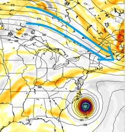
This is about as clear a recurve pattern as you can get for the US east coast. Has been for days and days...
-

E PA/NJ/DE Summer 2025 Obs/Discussion
JTA66 replied to Hurricane Agnes's topic in Philadelphia Region
Just hit 90F. Only made it to 86F yesterday, so that's 3 out of the last 4 days at 90F or above. Maybe not an official heat wave, but heat wavey enough for me -

2025 Atlantic Hurricane Season
BarryStantonGBP replied to BarryStantonGBP's topic in Tropical Headquarters
Happy birthday Kat
-
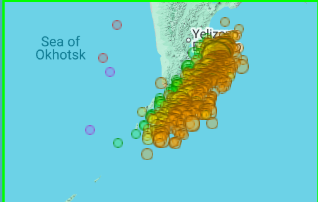
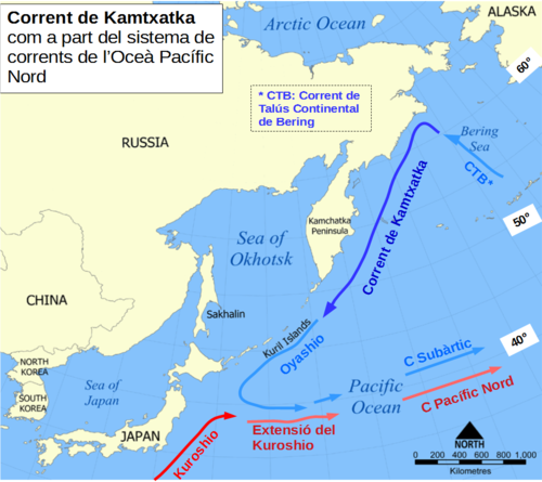
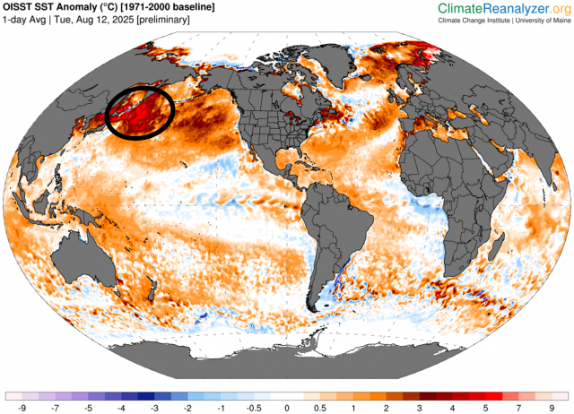
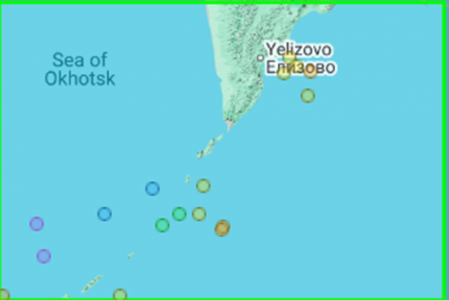
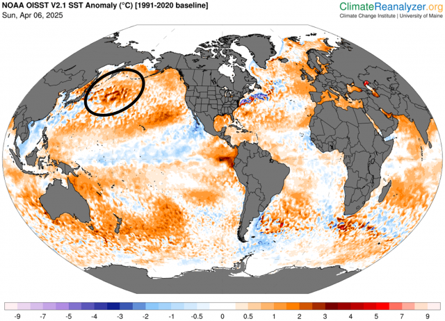
From Dr. Viterito via JB 8/14/25: I've been keeping a very close eye on this area, as it has been a geothermal hotspot helping to feed the Kuroshio Current, the Pacific's equivalent to the Gulf Stream. Did you notice at the very end of the video the narrator talks about the fact that geothermal heating enables the major port to be ice-free year round and that the area is used as a submarine base? "The "culprit" here is the submarine activity of the Eastern Volcanic Front off the east coast of Kamchatka." As the map shows, there has been a tremendous amount of underwater seismic activity in this area for the past 30 days. For the record, there have been 1036 seismic events, the vast majority of which are associated with underwater magma displacement. Keep in mind, these magmas can reach temperatures of 400 degrees C! IRIS/Wilber 3, Mx >=3, July 15 - August 14, 2025. The water off the east coast of Kamchatka moves southward vis the Kamchatka current. Here is a map of this: Wikidata The Kamchatka Current then feeds the Kuroshio Current, and in this case, is providing exceptional warmth to the Kuroshio. This is starkly illustrated in today's sea surface temperature map. In this map the source region is clearly the southeast coast of Kamchatka, and we can see that excess warmth being transported by the Kamchatka Current, which then merges with the Kuroshio. By contrast, here is the seismic map for March, 2025. For that month, there were only 17 seismic events: IRIS/Wilber 3, Mx >=3, March 6, 2025 - April 5, 2025. Here is the resultant SST map (April 6, 2026 [sic]): Clearly, the "hot spot" was much weaker when the seismic activity was lower. It can be argued that the Kamchatka source region is responsible for the large temperature anomaly the Kuroshio is currently experiencing. It's about time the climate community starts to recognize the importance of geothermal inputs into the system. ————————— Any comments?
-
0.0% chance. Stop being stupid.
-
2025 Atlantic Hurricane Season
BarryStantonGBP replied to BarryStantonGBP's topic in Tropical Headquarters
Won't be surprised if all these lot became bangers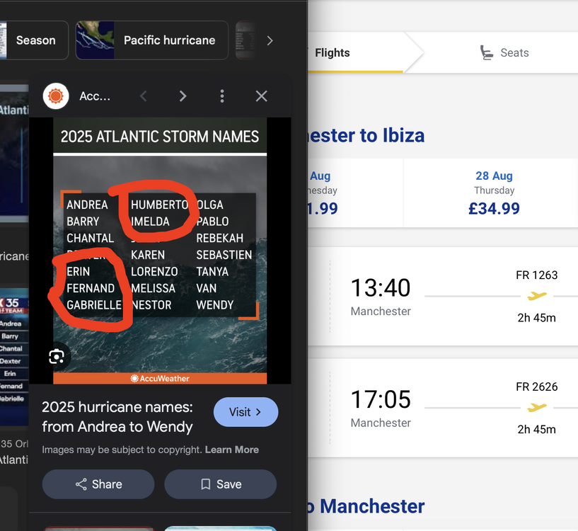
-
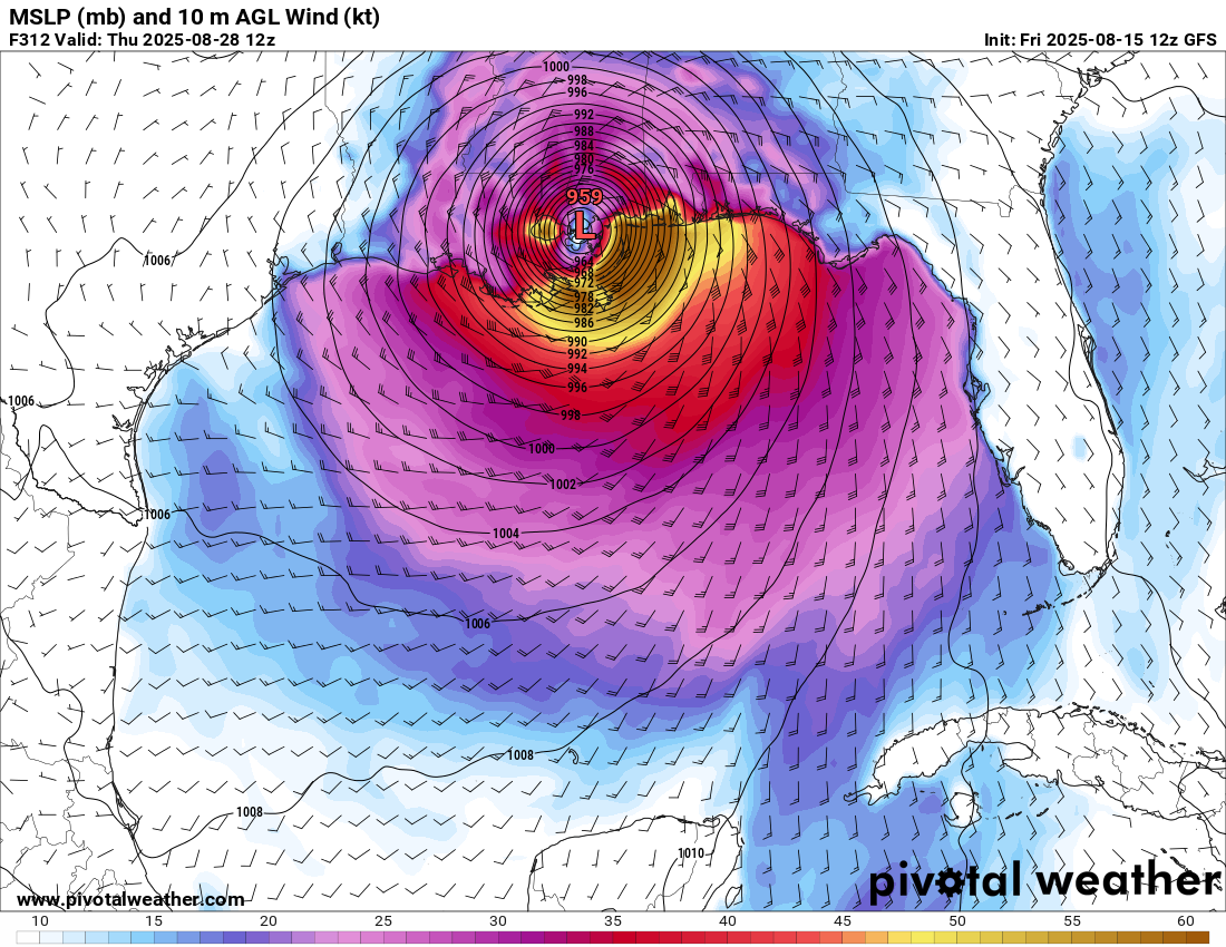
Hurricane Erin - 75 mph - 996 mb - WNW @ 18
BarryStantonGBP replied to BarryStantonGBP's topic in Tropical Headquarters
It's called tracking the tropics with a pint at Spoons mate. Now let's watch Erin score some category 5 goals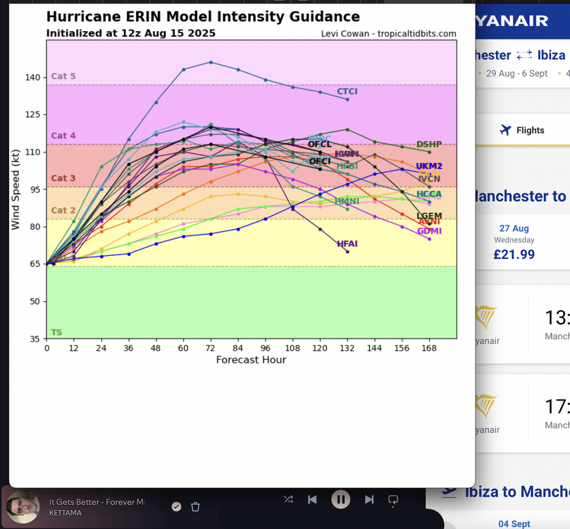
-
 I ran the numbers for 1995 and 1993 where summer mean temperature was weighted at 50% and where the remaining 50% weight was equally divided among the other three variables. In that case, 1993 tops 1995. 2010 remains at the top.
 -
with this flow structure aloft? it would take more than God's will actually. It's more apt to say ...what we are looking at is God's will NOT to bring this TC to New England. This has been a stalwart consistent limitation for days and days and model run after model run, all but 100% ... all along, yet for some reason, some of you cannot seem to even see or sense the intuitive reason why it is impossible to bring a TC up to New England with polar jet drilling straight at the region. It's like believing the fake news that it's possible for an ice cream cone to survive a fire hose I guess. We live in an era where scientific advice, let alone learning, are allowably suspended. It's not your fault.
-
Lol: The Trump administration’s claim that it is saving billions of dollars through DOGE-related cuts to federal contracts is drastically exaggerated, according to a new POLITICO analysis of public data and federal spending records. Through July, DOGE said it has saved taxpayers $52.8 billion by canceling contracts, but of the $32.7 billion in actual claimed contract savings that POLITICO could verify, DOGE’s savings over that period were closer to $1.4 billion. Despite the administration’s claims, not a single one of those 1.4 billion dollars will lower the federal deficit unless Congress steps in. Instead, the money has been returned to agencies mandated by law to spend it. DOGE’s savings calculations are based on faulty math. The group uses the maximum spending possible under each contract as its baseline — meaning all money an agency could spend in future fiscal years. That amount can far exceed what the government has actually committed to pay out. Counting this “ceiling value” gives a false picture of savings for taxpayers. “That's the equivalent of basically taking out a credit card with a $20,000 credit limit, canceling it and then saying, ‘I've just saved $20,000,’” said Jessica Tillipman, associate dean for government procurement law studies at George Washington University Law School. “Anything that’s been said publicly about [DOGE’s] savings is meaningless.”
-
That storm in northern Carroll Co is just not moving.
-
A pic of my COC

-
The humidity to rain ratio has been approaching infinity here lately.
-
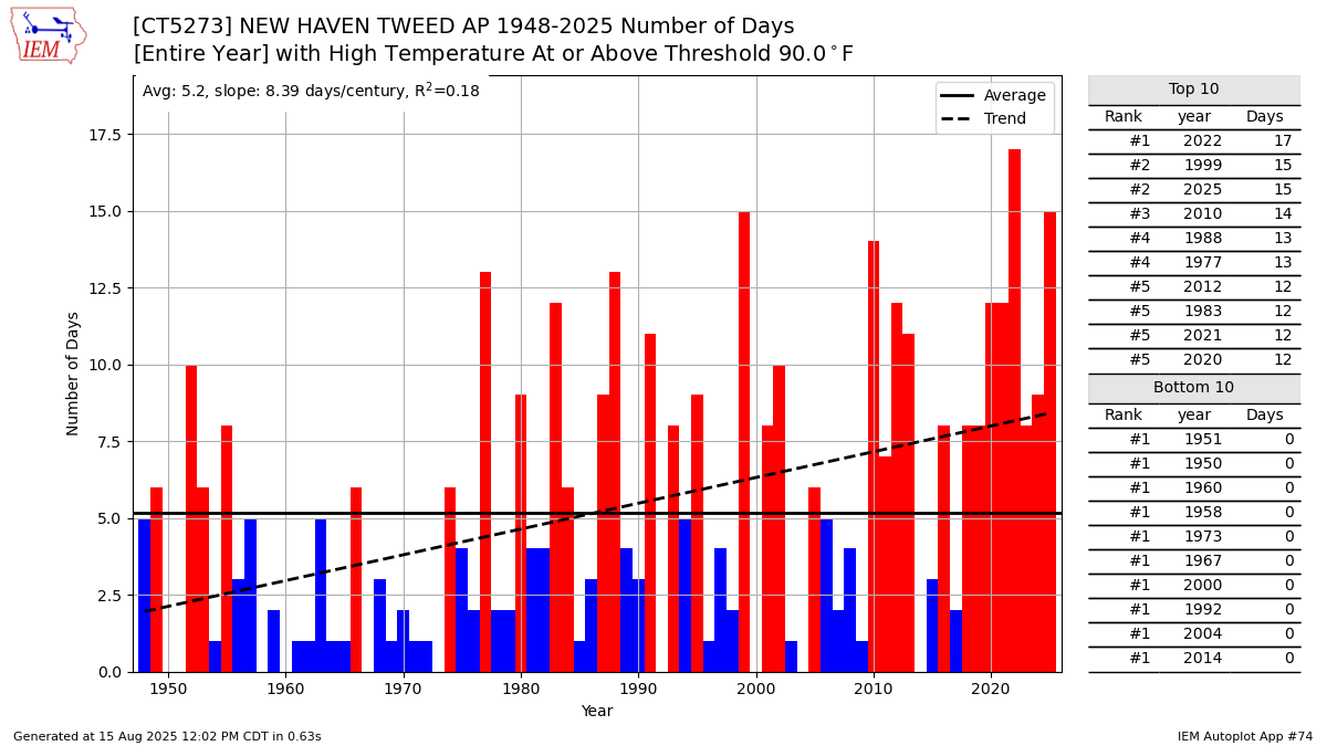
 Here on the CT Shoreline there has been a much steeper increase in 90° days than JFK. We are currently in 2nd place on the all-time 90° day list at 15 days so far reaching 90° or higher. This heat combined with the 5th driest summer so far has turned most of grassy areas brown. Was glad to get a brief shower yesterday. Time Series Summary for NEW HAVEN TWEED AP, CT Driest June 1st to August 14th Periods Click column heading to sort ascending, click again to sort descending. 1 2000-08-14 2.64 62 2 1957-08-14 2.77 0 3 1966-08-14 3.42 0 4 2017-08-14 3.50 3 5 2022-08-14 4.12 0 6 2025-08-14 4.18 0 7 1949-08-14 4.27 0 8 2016-08-14 4.82 0 9 1970-08-14 5.05 0 10 1965-08-14 5.09 0
-
 89/69/94 push push
 -
Can confirm. I’ve made that drive more times than I can remember and invariably the car is plastered in bugs. another hot day. Dp 70.
- Today
-
Looks like you're in the same boat as us, but Newfoundland is still close.
-
COC'd and loaded today, 76/57°F
-
Finally found a way to make a loop of SAL
-

2025 Atlantic Hurricane Season
WxWatcher007 replied to BarryStantonGBP's topic in Tropical Headquarters
There is a pretty good signal on the GEFS and EPS that the following wave will have a chance to develop in the central Atlantic, and a more modest signal that the wave train is probably going to be active for the next week or so--aided by the MJO and passage of the CCKW. Dry air and stability will remain hurdles waves need to overcome, but as we see each year, often times the lead wave (failed 96L or whatever it was) opens the door for the next one. It's unclear how much SAL will get back into the pathway, but look at how Erin cleared the way.