All Activity
- Past hour
-

Possible coastal storm centered on Feb 1 2026.
Damage In Tolland replied to Typhoon Tip's topic in New England
Gulf of America effect snow . It’s actually modeled -
Yea several of the regulars keep pointing out concern for McDowell, Burke, Rutherford. This is one I’m keeping low expectations and hope for a major surprise.
-

Possible coastal storm centered on Feb 1 2026.
RUNNAWAYICEBERG replied to Typhoon Tip's topic in New England
Tampa? -
Will this arctic blast kill the spotted lantern fly larvae??
-
Possible coastal storm centered on Feb 1 2026.
Damage In Tolland replied to Typhoon Tip's topic in New England
@RUNNAWAYICEBERGLet WPC get into his weed stash it seems . -

Possible coastal storm centered on Feb 1 2026.
NoCORH4L replied to Typhoon Tip's topic in New England
It really is. I face South, and the last 2 days where the spots where pavement is exposed have expanded drastically. Lots of refreezed crust ice at the edges, a tell tale sign of melting. -

February 2026 Medium/ Long Range Discussion: Buckle Up!
NorthArlington101 replied to Weather Will's topic in Mid Atlantic
You could make a compelling case today that the only guidance worth looking at until the short range for Ptype is the AIFS and you’d probably be right. This hobby is a lot less fun that way but it’s perhaps the way we are rolling. -

Possible coastal storm centered on Feb 1 2026.
SouthCoastMA replied to Typhoon Tip's topic in New England
I still think advisory is on table for Cape but its tenuous -

The “I bring the mojo” Jan 30-Feb 1 potential winter storm
Snowncanes replied to lilj4425's topic in Southeastern States
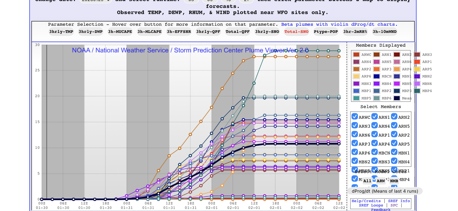
SREF plumes for RDU. 4 at 20+ 3 at 0. Crazy spread for 48 hours away
-
Possible coastal storm centered on Feb 1 2026.
Damage In Tolland replied to Typhoon Tip's topic in New England
3-6 for Atlanta and 1” in Tampa from this . Seems Normal -

The “I bring the mojo” Jan 30-Feb 1 potential winter storm
ragtop50 replied to lilj4425's topic in Southeastern States
During the Raleigh NWS briefing (posted on YouTube), they touch in this and emphasize that there very well could be a dry slot somewhere and that some people could end up with less than they are forecasting, but how do you put that on a map when you don't know where and to what degree (and it keeps changing)? So their amounts are outside of that happening. And just the same they mentioned some areas could obviously be higher. -
Maybe you guys can remember...when has the Euro been this far off (if what NBM shows is accurate) before? I cant remember. Over this wide of an area.
-
how's the Red Sox roster looking?
-

Possible coastal storm centered on Feb 1 2026.
WinterWolf replied to Typhoon Tip's topic in New England
Got a ton of snow on roofs here…he’s all messed up. -

The Jan 31 Potential: Stormtracker Failure or 'Tracker Trouncing
wasnow215 replied to stormtracker's topic in Mid Atlantic
Euro had the idea of more SE and a scrapper before GFS, GEM, AI's and others. Now it' shows a little more snow than most of the models. We shall see. -
Foothills weather Mets seem certain there's going to be a minimum with less than 3 inches of snow for us up to Mt Airy
-

Is we back? February discussion thread
40/70 Benchmark replied to mahk_webstah's topic in New England
11/13. -
Possible coastal storm centered on Feb 1 2026.
Damage In Tolland replied to Typhoon Tip's topic in New England
Please check radars and post and drive as safely as you can -

Possible coastal storm centered on Feb 1 2026.
George001 replied to Typhoon Tip's topic in New England
I thought the models would correct west today. They didn’t, but it’s still a massive ocean storm where even a 50 mile NW bump would make a huge difference. It’s too early to throw in the towel especially for eastern areas. -

Possible coastal storm centered on Feb 1 2026.
FlashFreeze replied to Typhoon Tip's topic in New England
on my way back to South Carolina and coming down route 8 through Thomaston pretty good snow squall that’s not showing up on radar, I guess it’s getting me ready for the five or 6 inches of snow forecast for North Myrtle Beach -

The “I bring the mojo” Jan 30-Feb 1 potential winter storm
digital snow replied to lilj4425's topic in Southeastern States
RAH maps have consistently been showing more snow than forecast. TV mets have to be conservative, and I don't pay attention to social media mets for the obvious reasons. NWS has been consistently showing a jackpot from southern pines north to alamace/orange county line. I am with y'all. The models are not spitting out those numbers for the most part, but the nws maps keep going up. When that reverses course, I will change my thinking. I also remember a storm in early/mid 2000's that dropped heavy snow 12+ in in Charlotte and 12+ on the obx while rdu had a few inches. Bush was visiting Charlotte that day. I can't remember important shit, but I remember that for some reason. Anyway, the double jackpot dry slot blah blah can and has happened, but until the nws maps change, I am not buying it. -
we're now at 7/29 equivalent sun angle and headed "downward" into Spring. the leaves sure look leathery - however the snow is banked up really high, and it can be a long uphill fight out of this mess
-

February 2026 Medium/ Long Range Discussion: Buckle Up!
SomeguyfromTakomaPark replied to Weather Will's topic in Mid Atlantic
It’s kinda crazy how similar the ai gfs and ai euro look at 156, the surface maps are almost identical. I wonder if the days of purely physics based medium and long range modeling are numbered. -

Possible coastal storm centered on Feb 1 2026.
CoastalWx replied to Typhoon Tip's topic in New England
No snow and all cold make weenies a dull boy. -

Possible coastal storm centered on Feb 1 2026.
tomcatct replied to Typhoon Tip's topic in New England
Oh there's one.. She says it's gonna snow and i fucking believe her