All Activity
- Past hour
-

January 2026 regional war/obs/disco thread
WinterWolf replied to Baroclinic Zone's topic in New England
When that disappears. -
Widespread > 12" east of Colorado and south of 42N rarely happens, but the GFS loves to show it.
-
None of theGFS will happen and that to ar as models are having hard time 3 days out. Those temps are fun to look at another joke. I only care about tomorrow through Sunday for my drive to Eagles Mere and home Sunday. Tomorrow there expected. 25" of rain.
-

Pittsburgh/Western PA WINTER ‘25/‘26
Rd9108 replied to Burghblizz's topic in Upstate New York/Pennsylvania
Could you imagine if we ever got a storm over 30 again. This board would be going crazy. I would not be going to work. -
I was happy to help.
-
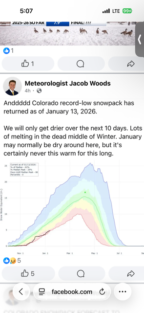
Here’s more about the superlatively snowless western winter so far. Seems like a clear illustration of why focusing on moisture - as much if not more than cold - ought to be central to winter forecasting, at least for areas that are not typically mild to warm.
-

Winter 2025-26 Medium/Long Range Discussion
andyhb replied to michsnowfreak's topic in Lakes/Ohio Valley
Ok but seriously, what in the actual hell happened with that run? -
I meant to verify
-
-
Entire tri-state area gets clobbered by an ice storm/sleet storm on the GFS 18z at 270 hours. It shows 16 at the surface, primary low around SC/TN, secondary low forming off the Delmarva coast. Completely laughable. But boggles my mind on how these models come up with this stuff.
-
There's a 96" in there in SW PA. But about 20" of it is from before/after to big storm.
-

E PA/NJ/DE Winter 2025-26 Obs/Discussion
LVblizzard replied to LVblizzard's topic in Philadelphia Region
You know why I like that 18z GFS fantasy storm? Because that’s the day I’m supposed to drive back from New England. It makes perfect sense that we’d time a HECS perfectly like that. - Yesterday
-
I am with you on that bet. But someone will take the over on the snowfall, under on temps, and one day they will get that huge payout.
-
There is that weenie model that we would all love to see. Maybe the low a tad further east to avoid any mixing issues along the twin forks, south shore of LI. Likelihood of this 276 hour model being correct? Very low. Show it to me again when it is within 5 days, and it will get me interested in it. bring those big snow totals further east and you will get a lot of snow weenies very excited. Even if this is for 360 hours out. :)
-
Wouldn’t be too far to chase because it’s nada here
-
I’m here after viewing the 18z gfs. Arctic cold leading into a southern stream feature sounds kinda fun.
-

January 2026 regional war/obs/disco thread
Bryan63 replied to Baroclinic Zone's topic in New England
I am travel for work the week of the 27th so you can pretty much lock that storm in now. -
One of the camps of models is going to be wrong. Way wrong at that. Will the MJO win or the models win?
-
The way things are going, it's really hard to say. For all intents and Purposes P6 should be warm going by the Chart's. It's obviously not . As we know, the MJO has been of low Amp or in the COD alot. Also, the Kelvin and Rosbys have been creating chaos as you've been pointing out. My take is, like you, there'll be a strong but probably short lived warm-up. If the depiction from the EC you posted is correct it may last longer. I just don't buy that deep of a Trough out West. Just my 2 cents worth.
-
On those last two maps I'll take the under on the snowfall and the over on the temps. I'll also take a bet that the 00Z run offers a vastly different solution.....360 op progs = useless and serve no purpose.
-
Of course it'll verify from Michigain all the way to Maine, cause we all know it doesn't snow here anymore.
-
Yeah towards or into next weekend
-
LOL @ all the butt hurt in this thread on a so called “science board”.
-

January 2026 regional war/obs/disco thread
cleetussnow replied to Baroclinic Zone's topic in New England
Whining fires up in earnest after 0z runs tonight….until April -

January 2026 regional war/obs/disco thread
The 4 Seasons replied to Baroclinic Zone's topic in New England
i like that. it was a Sopranos reference, i guess no one picked up on that


