All Activity
- Past hour
-
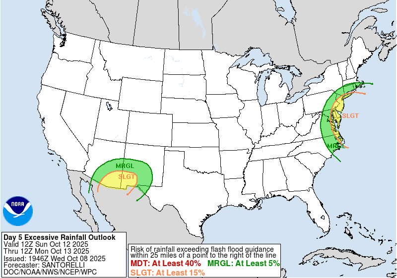
WPC Excessive Rainfall Forecast for Sunday-Monday
-
I really can't recall the last time a seasonal map didn't show AN temperatures at long leads. Even when we ice boxed last January and were solidly BN for Jan 2024, I'd be surprised if modeling around this time of year didn't show AN temps for January both years.
-
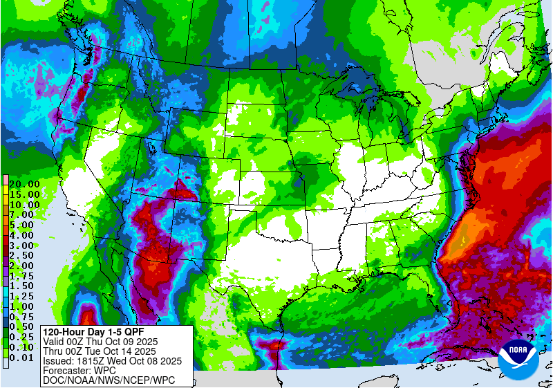
WPC QPF through day 5-
-
Latest Mount Holly AFD- A potentially significant coastal storm looks to be on the horizon Sunday through Monday. However, the forecast remains uncertain and significant changes could come as we get closer. Main impacts will be tidal flooding, strong marine winds (and potentially on land if the system tracks closer), and heavy rain. Things start to go downhill on Saturday Night as a coastal low approaches from the south. Rain is expected to overspread the region, with the heaviest near the coastline, while areas in the Lehigh Valley/Poconos/northern NJ likely stay dry through the night. Winds begin to increase, especially over the water and along the immediate coastline with gusts getting near 40 MPH by daybreak. Sunday through Monday will be when our area likely experiences the brunt of the impacts from the coastal storm. If the current track holds and the coastal storm does end up just offshore, strong winds are expected, upwards of 45-55 MPH+ on the coast Sunday afternoon and Sunday Night, with the potential for these strong winds to continue well into Monday. Gusts upward of 30-40 MPH will extend several miles inland to about the I-95 corridor. In addition to the wind, heavy rain is expected, and a SLIGHT (2/4) Risk Excessive Rainfall Outlook is in place for the I-95 corridor and points south and east. We are not fully in the QPF period yet, but some of the WPC longer-range rainfall products suggest 2-4+ inches of rain within the SLGT risk, with locally higher amounts certainly possible. NBM Probability of 2+ inches of rain for New Jersey and Delmarva was about 30-40%, which is actually quite high being 5-6 days out.
-
If I was rich I’d totally get a mesonet station installed on my palatial estate. Somewhere between the pool and the botanical garden.
-
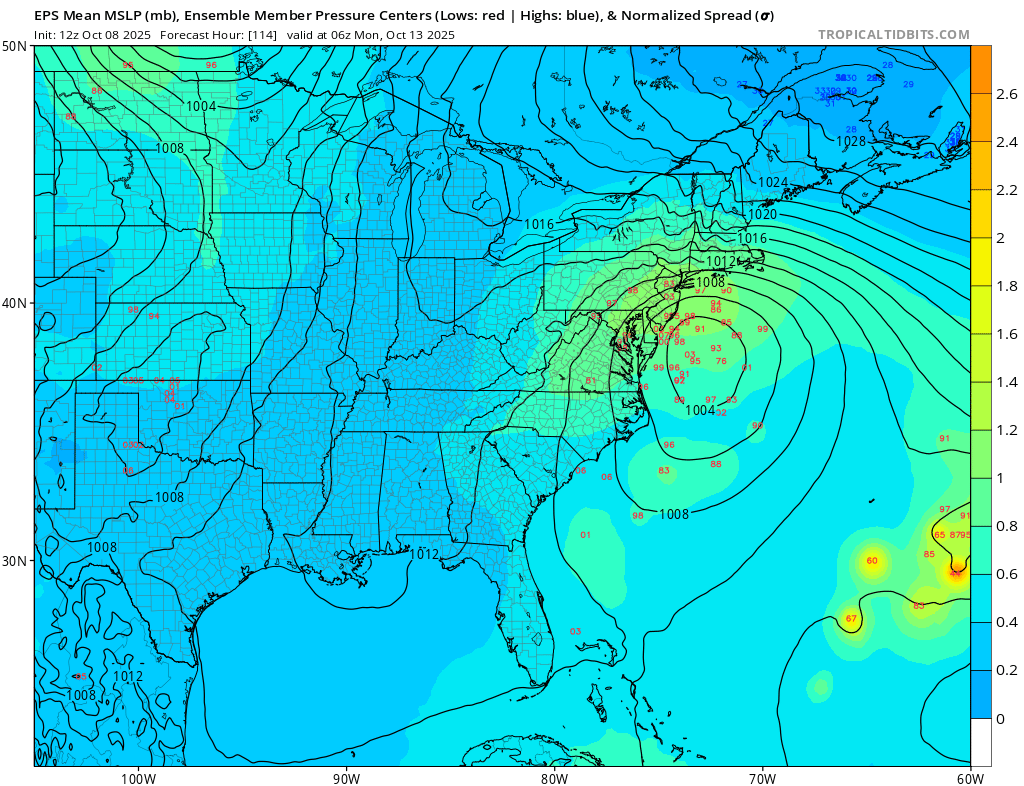
Eps is amped

-
That sucks man. This shit is so ridiculous and shouldn't be happening. Hopefully you are back to work soon! I liked the post because you had a fun time and that is super cool.
-

E PA/NJ/DE Autumn 2025 Obs/Discussion
KamuSnow replied to PhiEaglesfan712's topic in Philadelphia Region
About my sentiments as well, received 0.12" here. Hoping for some rain from the coastal later this weekend, also hope Chadzachadam has contingency indoor plans for Sunday! -
I want a minimum of seven tropopause folds
-
Records: Highs: EWR: 89 (2007) NYC: 87 (2007) LGA: 89 (2007) JFK: 90 (2007) Lows: EWR: 32 (1935) NYC: 37 (1988) LGA: 40 (1988) JFK: 40 (2001) Historical: 1871 - Prolonged drought and dessicating winds led to the great Chicago fire, the Peshtigo horror, and the Michigan fire holocaust. Fire destroyed more than seventeen thousand buildings killing more than 200 persons in the city of Chicago, while a fire consumed the town of Peshtigo WI killing more than 1100 persons. In Wisconsin, a million acres of land were burned, and in Michigan, 2.5 million acres were burned killing 200 persons. "Tornadoes of fire" generated by intense heat caused houses to explode in fire, and burned to death scores of persons seeking refuge in open fields. (David Ludlum) (The Weather Channel) 1871: The Great Chicago Fire burns much of the city to the ground, fanned by strong southwest winds. An estimated 250 were killed. On the same night, forest fires swept through Peshtigo, Wisconsin. An estimated 1,500 to possibly as many as 2,500 dies as gale-force winds push flames across town. Severe drought blamed for tinder-dry conditions. 1878: An estimated F3 tornado struck Monticello, Iowa, around 5:30 pm. The Catholic Church was demolished, along with several homes. The business portion of the town was comparatively uninjured. While no lives were lost, 11 people were injured. The German Church in Richland township was destroyed, along with other buildings in the surrounding county. A wind and hail storm occurred during the evening hours in Sigourney, Iowa, causing considerable damage. Fences and shade trees were blown down, and much glass was broken by hail, which fell in large stones. 1901 - A deluge at Galveston, TX, produced nearly twelve inches of rain in about a six hour period. The rains came precisely thirteen months after the day of the famous Galveston hurricane disaster. (David Ludlum) 1919: An intense tornado moved through the town of Hoisington, 11 miles north of Great Bend, Kansas. It damaged or destroyed 60 homes which resulted in $200,000 in damages. Business papers and canceled checks were found at Lincoln, 55 miles to the northeast. 1946: A minimal Category 1 hurricane made landfall over Bradenton, Florida, before tracking north-northeast across Tampa Bay. The storm was the last hurricane to make direct landfall in the Tampa Bay area. 1982 - An unusually early snowstorm hit the northern Black Hills of Wyoming and South Dakota. The storm produced up to 54 inches of snow, and winds as high as 70 mph. The snowfall was very much dependent upon topography. Rapid City, 20 miles away, received just a trace of snow. (The Weather Channel) 1987 - Unseasonably cold weather prevailed from the Upper Mississippi Valley to the southeastern U.S. Thirty cities reported record low temperatures for the date, including Madison WI with a reading of 22 degrees. The low of 28 degrees at Evansville IN was the coolest of record for so early in the season. Hot weather continued in the southwestern U.S. Phoenix AZ reported a record high of 104 degrees and a record tying 116 days of 100 degree weather for the year. Tucson AZ established an all-time record with 72 days of 100 degree weather for the year. (The National Weather Summary) 1988 - Snow was reported across parts of northern New England. Two inches blanketed Mount Snow VT. Warm weather continued in the northwestern U.S. The afternoon high of 80 degrees at Stampede Pass WA exceeded their previous record for October by seven degrees. (The National Weather Summary) 1989 - Morning lows in the 20s were reported from the Northern Plains to the Upper Great Lakes. International Falls MN and Marquette MI reported record lows of 22 degrees. Unseasonably warm weather prevailed in central California as the Oakland Athletics won the American League pennant. San Luis Obispo CA reported a high of 99 degrees. (The National Weather Summary)
-
Have a pretty optimistic view that this will be the catalyst for a reanalysis of tornadoes from recent years for revisions to their ratings.
-

Spooky Season (October Disco Thread)
WxWatcher007 replied to Prismshine Productions's topic in New England
Kind of how I feel with the new location, though they’ve done well relative to normal lately. Maybe I need to wish for more of the same -
Super cool. Thanks to @Eskimo Joeand @wxmeddler for inviting me! Nice consolation prize for being furloughed.
-
.thumb.jpg.6a4895b2a43f87359e4e7d04a6fa0d14.jpg)
Central PA Fall Discussions and Obs
Yardstickgozinya replied to ChescoWx's topic in Upstate New York/Pennsylvania
- Today
-
Latest discussion from NWS Sterling. Kudos to them for working without pay during the suspension of operations. .LONG TERM /SATURDAY THROUGH WEDNESDAY/... A coastal low pressure system continues to bring plenty of uncertainty to the forecast for the upcoming weekend into early next week. Synoptically, we will remain in a split flow pattern caught between the northern and southern branches of the jet stream. Surface high pressure will gradually push east from southern New England into the western Atlantic through the weekend while an area of low pressure pushes north along a stalled boundary at the southeast U.S. coast. Meanwhile, closed low pressure looks to dig south from the Great Lakes/Ohio River Valley into the Mid-Atlantic during the weekend timeframe. Deterministic and ensemble model solutions continue to exhibit large spread when it comes to how these features interact, although some consistency has been noted in the latest 12z solutions. The biggest question overall is to how far south the closed low feature digs into the region and its overall placement to interact with the incoming coastal low. The 12z EPS continues to favor a solution where the cutoff low pressure system has some interaction with the incumbent shortwave/cutoff low over the Northeast. The 12z GEFS also favors some interaction between the cutoff low and coastal low, especially toward the back half of the weekend into early next week. Both solutions suggest increasing rain chances late Saturday into Sunday, especially in locations east of the Blue Ridge and toward the I-95 corridor. Some shower activity may push toward the mountains, but is highly dependent on the timing/placement of the coastal feature and interaction with the closed low/shortwave feature which looks to pass just over/north of the region. Either way, this is a highly volatile forecast with many moving parts that will have to be closely monitored. A blend of the solutions would suggest increased cloud cover, seasonable temperatures, and blustery conditions (especially by the waters) for the upcoming weekend ahead. Precipitation chances look to increase from the southeast Saturday afternoon and evening as the influence of high pressure kicks further into the western Atlantic, and coastal low pressure moves toward the Carolinas. Rain chances will continue to increase for all locations with an emphasis for those east of US-15 Sunday into Monday as low pressure lifts up toward the Delmarva, and the shortwave trough/cutoff low nears. Rain chances will decrease Tuesday as the cutoff low/shortwave trough pushes east, and the coastal low retrogrades back south toward the Carolinas. High pressure returns thereafter for the middle part of next week. Persistent east to northeasterly flow will lead to below normal temperatures through early next week. Highs should remain in the 60s with overnight lows in the 40s to mid 50s. Rainfall chances are generally confined to areas along and east of I-95, and generally capped at 30 to 50 percent. There is certainly room for this to change based on the track of the coastal feature. Expect wind gusts of 20 to 25 mph over land Sunday with gale gusts possible over the waters. Stay tuned and check back at weather.gov/lwx for the latest.
-
Yup
-
@WxUSAF, @wxmeddler, and I did a thing today!
-
Stronger would actually be a negative for us I think. Stronger would yield quicker occlusion and alot of the processes would begin shutting down. Ultimately, would lead to less wind/rain, especially away from the coast.
-
0.29” in the overnight/pre-dawn/dawn hours.
-
Yes... I want to do some outside work while still daylight but all ensembles now on board, despite the 12z/8 CMCE OP OTS. widespread wind driven 1", iso MAX 4 12z Sun-12z Tue G 50-60 Mph LI NJ coasts, beach erosion, multiple cycles of at least MINOR CF, with potential for major NJ coast Sun and Mon highest tide cycles. Probably start it around 8P.
-
.thumb.png.4150b06c63a21f61052e47a612bf1818.png)
Spooky Season (October Disco Thread)
HIPPYVALLEY replied to Prismshine Productions's topic in New England
Save yourself the frustration and just throw yourself in the snowblower auger now. -
The rain gauge is responding to commands. So it's not broken. I called the folks down there and they said it did rain, but "barely anything". Could be that it got some debris in it. Someone will be up there tomorrow to inspect / clear it out.
-
Spooky Season (October Disco Thread)
HIPPYVALLEY replied to Prismshine Productions's topic in New England
Only about .15” in Greenfield -
Bingo. Google Form with the responses routed to a Google Sheet.
-
Frost Advisory tonight. It'll be "low tire pressure light" season before you know it.