
All Activity
- Past hour
-

October Comes Early: Late September Multi-Hazard Hybrid Storm
Layman replied to WxWatcher007's topic in New England
-

October Comes Early: Late September Multi-Hazard Hybrid Storm
SouthCoastMA replied to WxWatcher007's topic in New England
The connection to CC that I've read on this board is that PWATS are generally 10% higher for any given system. I'm likely oversimplifying that, but I'm not a met. Looks like I'm finishing at 6.31" -

Strong Nor'Easter/Hybrid Storm Late September 2026
straphanger replied to Rjay's topic in New York City Metro
Finishing up with a 4 day total of 2.87" here. The sun is struggling to break through now and everything is probably going to stay soggy for the remainder of the day. -
October Comes Early: Late September Multi-Hazard Hybrid Storm
tavwtby replied to WxWatcher007's topic in New England
2.12" now, most fell between yesterday afternoon and now -

Strong Nor'Easter/Hybrid Storm Late September 2026
jm1220 replied to Rjay's topic in New York City Metro
We’re totally in the “just get this the F out of here” stage. -
1.1” for me. From the storm. Get your mind out of the gutter.
-
NWS-NYC mentioned 90F being possible. I wish they hadn't changed their AFDs, though, as they rarely speculate on storms beyond 4-5 days any more and I'd like to know what they're thinking for Saturday (any rain with the front) and Sunday - almost every model is showing major rain on Sunday (1-2+" - starting late Sat on some). .KEY MESSAGE 3... The modeling has been in good agreement for some time, including the CPC outlooks, that a quick warming trend will impact the area this week. This timing now looks to be focusing in on Thu and Fri before a cold frontal passage cools things off again. The NBM indicates 70s to near 80, but temps aloft combined with progged wly component winds would support highs near 90, especially the usual warmer spots in NJ and NY.
-

2026-2027 Record-breaking El Nino
Yanksfan replied to Stormchaserchuck1's topic in Weather Forecasting and Discussion
Despite how strong this El Niño gets its influence over the pattern will be restricted due to the fact that it’s not coupled. Expect a wide range of variables with the overall pattern this winter. -

super el nino banter thread
Tallis Rockwell replied to forkyfork's topic in Weather Forecasting and Discussion
We'll be finished before it gets to 8 C -

October Comes Early: Late September Multi-Hazard Hybrid Storm
jbenedet replied to WxWatcher007's topic in New England
Location? -

October Comes Early: Late September Multi-Hazard Hybrid Storm
ineedsnow replied to WxWatcher007's topic in New England
Winds are ripping... waves and splash over is awesome at high tide ill post pics when I get home later but this is awesome! -
 ed meds on line: ApexMenMeds - cheap ed medication
 -
exceptional
-

October Comes Early: Late September Multi-Hazard Hybrid Storm
Great Snow 1717 replied to WxWatcher007's topic in New England
can you email the boston on air TV mets and tell them they should also be looking out the window?? lol -

October Comes Early: Late September Multi-Hazard Hybrid Storm
WinterWolf replied to WxWatcher007's topic in New England
He needs to go back and critique his forecast for this…and then give himself a letter grade. Hint: The letter comes after E. -

October Comes Early: Late September Multi-Hazard Hybrid Storm
Brewbeer replied to WxWatcher007's topic in New England
we don't need media for that - we can look out the window -
Buy Tadalafil 20mg [url=https://tadastreamrx.shop/#]TadaStream[/url] Buy Cialis online
-
Ying Yang
- Today
-
Maybe if we get a good collision of cool air and warm air, we'll get some good thunderstorms.
-

2026-2027 Record-breaking El Nino
GaWx replied to Stormchaserchuck1's topic in Weather Forecasting and Discussion
Wow, the WCS daily PDO continues to plunge back down as it’s fallen to -1.74 in the midst of a record strong El Niño! How is this happening? It was -1.10 just 5 days ago.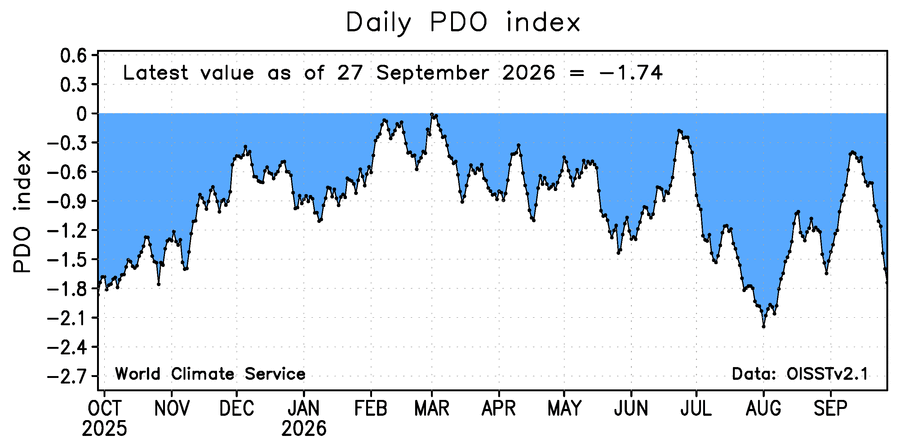
-
just in time for a return to summer around Halloween.
-
we will be playing 4:30-6:30pm!
-

October Comes Early: Late September Multi-Hazard Hybrid Storm
Typhoon Tip replied to WxWatcher007's topic in New England
probably not... The short reason for that is because it's not deemed or shown to be as necessary. That and general societal apathy to responsibility - but this latter aspect is a sociological crisis for a different time. LOL when I was Met zygote ( heh ) it was required. Everyone had to ... because everyone new the models were just not that reliably precise. They're better, but I'm sure there's a lot of arguers that say otherwise. I can tell from experience in both eras, pre and post 2000, there have been less in the way of vaster positive(negative) busts, respectively since then. The frequency being down hearkens to more reliance. Frankly, it's depressing... there was always a chance that so-and-so would end up being more. But you took the good with the bad ...sometimes, a lot of time, it was the other way. Man, the 1980s were notorious for epic Charlie Brown blizzards. The 1990s were better at not setting up everyone for magnificent ghosts, but interestingly ... missed more on the positive side. We seemed to get one good snow event a winter that was a rush to warn scenario. . I've extolled the awesomeness of Dec 23 1997 several times. 1-3 of glop --> 20" of powder. Anyway, the models have gotten to point where as much as we may be less charmed, they are still at a different level of usefulness than they were prior to 2000. That's just existential. So anyway... the urgency and need for now-casting isn't considered a priority, because the intra-event variances of the different storm metrics ... mm they don't go crazy like that anymore. Might even be presumptive. You know, the Boxing Day storm in 2010 ...that as "quasi positive bust" imo. Because it had been suppressed to the point where there really was not system any long on the charts for a couple of cycle at the low/ghosted most point. Then, inside of 72 hours it merely hinted. It really wasn't until 36 hours that it came roaring back. By 2010, that's bordering on model failure on the positive side. Relative to the state of the art of the time, that was really all but too late. In this current dying system... I'm not sure this needed to be down(up) gradated over what was original 'cast. We'll see how the objective accounts lays out during postmortem but it seems so far that it was acceptable gains(losses) wrt that. -

October Comes Early: Late September Multi-Hazard Hybrid Storm
WxWatcher007 replied to WxWatcher007's topic in New England
What Ray said. It’s interesting how the valley produced another minimum in wind and rain, but only to an extent. I’m at 2.66” on the event and counting. -
2026-2027 Record-breaking El Nino
GaWx replied to Stormchaserchuck1's topic in Weather Forecasting and Discussion
Were in another very long -SOI streak, 47 days! https://data.longpaddock.qld.gov.au/SeasonalClimateOutlook/SouthernOscillationIndex/SOIDataFiles/DailySOI1887-1989Base.txt











