All Activity
- Past hour
-

Septorcher 2026 Discussion - Endless Summer
Typhoon Tip replied to Damage In Tolland's topic in New England
I would just caution that when models start backing in low at 5-7 days lead, it usually symbolic if not processing 'getting ready' to collapse one way or another. -

Central PA Summer 2026 Discussion/Obs Thread
MacChump replied to Voyager's topic in Upstate New York/Pennsylvania
kid's a freshman at PSU, going to see her this weekend and to our first game tomorrow, first real taste of fall looks like...about time! -
so, water
-
i miss your ipa names
-
Yeah picked up a bit of sprinklage here.
-
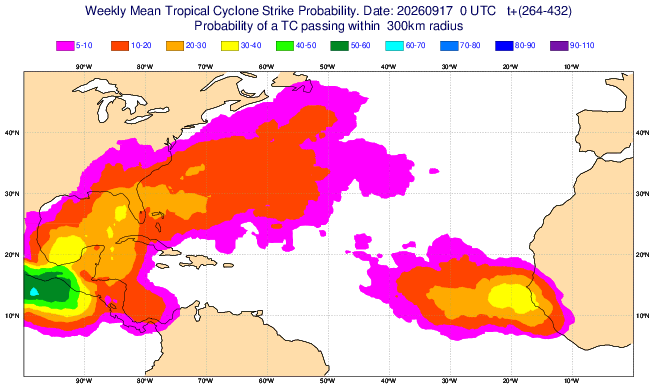
Yesterday’s Euro Weeklies suggested a pretty active period in and near FL during the week of Sept 28-Oct 3rd. This suggests a recurving TC in that area is quite possible: This matches long-term climo well, which is at least close to the most active period for FL throughout the season: These 5 strong+ El Niño analogs with hits in FL during or near this active period shown on the Weeklies suggest to be wary especially in FL then although it’s interesting that these 5 were all 1902 and earlier as the subsequent 11 strong+ Ninos didn’t have a FL hit around then: 1902: 1899: 1896: 1888: 1877:
-
I’m tempted to do a rainfail contest for Sunday - Wednesday.
-

Fall 2026 Medium/Long Range Pattern Thread
KakashiHatake2000 replied to John1122's topic in Tennessee Valley
https://www.facebook.com/WKRNDavisNolan/posts/pfbid0dPn5tsocRuz5JK1VgL9FgdhRUQvgX2VisfbxureuofMDEvLcfEsijeuUPjhNAVqfl yep Davis Nolan among other meteorologists are forecasting a cool down coming towards the middle to end of next week looks refreshing . -
 https://getbelvion.com/# Buy generic 100mg Viagra online
 -
This moment 23 years ago was exciting. Here's to another day like that soon.
-
Hello Rob + everyone. Didn’t want to see the thread go Sunday to Sunday without a post. As always …….
-
Was about to post about that! WOW
-
The ensemble means are wetter than the OPS.
-
Let’s see how good the Ggem really is lol
-
Whoa
-
This is no different from always. Go with the seasonal trend. Dry.
-
Half inch on sunday and that's about it
-
80s have become more common in October during the last decade. We even had November 80s two years during the 2020s. The average for warm spots like Newark has been 4 days reaching 80° past the end of September. Monthly Number of Days Max Temperature >= 80 for NEWARK LIBERTY INTL AP, NJ Oct-Nov Click column heading to sort ascending, click again to sort descending. Mean 3 0 4 2025 4 0 4 2024 4 2 6 2023 6 0 6 2022 0 1 1 2021 5 0 5 2020 0 0 0 2019 3 0 3 2018 3 0 3 2017 5 0 5 2016 3 0 3 First/Last 80° Summary for NEWARK LIBERTY INTL AP, NJ Each section contains date and year of occurrence, value on that date. Click column heading to sort ascending, click again to sort descending. Minimum 02-21 (2018) 09-28 (2020) 181 Mean 03-28 10-18 203 Maximum 04-15 (2024) 11-06 (2024) 2025 03-29 (2025) 85 10-07 (2025) 83 191 2024 04-15 (2024) 83 11-06 (2024) 83 204 2023 04-06 (2023) 83 10-28 (2023) 84 204 2022 04-14 (2022) 88 11-07 (2022) 81 206 2021 03-26 (2021) 84 10-20 (2021) 80 207 2020 03-20 (2020) 80 09-28 (2020) 81 191 2019 04-08 (2019) 80 10-07 (2019) 80 181 2018 02-21 (2018) 80 10-11 (2018) 81 231 2017 04-10 (2017) 82 10-21 (2017) 81 193 2016 03-09 (2016) 82 10-19 (2016) 87 223
-

Septorcher 2026 Discussion - Endless Summer
ineedsnow replied to Damage In Tolland's topic in New England
Some 12z EPS members look fun -
SPC has day 2 marginal risk out for east i65 Cumberland plateau and almost the majority of east tn for tomorrow Saturday for 5% damaging winds .
-
How? Looking at national, regional and local radars shows a goose egg. Apparently, radar is down nation-wide at 2:30 pm.
-
Well there is MGD 64. As always ……
-
Euro- What storm? Enjoy the nice north winds and cool temps. I'm not mad at it lol
-
Euro is now dry for most of next week. I know it's gonna be a cloudy cool pattern with the east winds, but it's possible that we won't get much rain.
-
Fort Collins has had 2.78" (roughly 2.50" on CoCoRAHS) vs an average of 3.05" in 60 days