
All Activity
- Past hour
-

Central PA Spring 2026 Discussion/Obs Thread
Superstorm replied to Voyager's topic in Upstate New York/Pennsylvania
Picked up 0.55” of rain so far today in Lancaster. Now 4.07” for month. . -
What a wonderful winter season it was.
-
I like the NAM gust 50 Saturday afternoon with attempts in the 40s. That’s cute.
-
Yeah, I hear ya, you hope we can get one of those 20 C 850 plumes from that direction. I’m not sure that’s the best direction for big heat not really a Sonoran heat connection but I suppose it’s possible. Probably will be a dry heat too. We shall see. Just not sold it on anything more than a day or two.
-
Looks like the warm front has been shoved south a bit. I'm thinking locations south of US 50 are probably better placed for afternoon convection?
-
 Perfect conditions for the 'brown heavy haze' to return if that locks in for a while.
 -
Approx 3/10” so far today imby/Columbia thru 11am.
-
Ha more rain. Much needed
-
Soupy out. DP up to 72
-
Love em.
-
Set a 'warm minimum' at 64.3 degrees, old mark was 63 from 1981. About 2.5" since the rain returned. Someone close by has gotten a good bit more, the river was up about 3 feet above normal and brown. 1st time I'll seen that in a while.
-

2026-2027 Strong/Super El Nino
40/70 Benchmark replied to Stormchaserchuck1's topic in Weather Forecasting and Discussion
Yea, I was thinking the same thing. That was supposed to be a mild winter that ended up even milder than expected. -
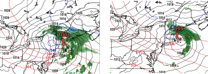
So earlier I intimated I suspected this thing this weekend might try to charlie brown the cold dweebs and their private/secret thinking that it's totally okay to snow at this time of year ... , by normalizing the metrics some as we move into the shorter range. In other words, it should correct to just insulting to us normal folk - While it is the NAM, and therefore ... probably not altogether very useful or trustworthy at this range, it is still showing some normalization in this 12z run... Left is the 00z 84 hour fantasy, the right in the 12z 72 hour ( same time), 12z Sat Clearly the right/more recent version is stepping off the cold enthusiast enabling throttle. Altho it's odd that the NAM pretty obviously dampens cyclogen thermodynamics and mechanics, while still making the low deeper...
-

E PA/NJ/DE Spring 2026 Obs/Discussion
The Iceman replied to PhiEaglesfan712's topic in Philadelphia Region
Every model was too far south with the precip today. Looks like southern PA on south should get at least another .25” today. Coming down at the moment here in Levittown and we had stuff come through overnight too for .15”. -
78 warmer than yesterday/hr by a couple clicks. Yesterday was 83... today should be 86 or 87. The clouds might offset the typical MOS too cold by 2 and make it look right this time. yay
- Today
-

Mountain West Discussion
mayjawintastawm replied to mayjawintastawm's topic in Central/Western States

-
Permanent DST has been tried and failed. 830-9 dark mornings in the winter are terrible for kids, pedestrians, etc. Far worse than it getting darker at 730 in July
-

Central PA Spring 2026 Discussion/Obs Thread
Itstrainingtime replied to Voyager's topic in Upstate New York/Pennsylvania
Maytown must be one of the unlucky areas this morning - just checked and I've only added .02" to bring my total to .07". Even less has fallen at the airpark. -

2026-2027 Strong/Super El Nino
michsnowfreak replied to Stormchaserchuck1's topic in Weather Forecasting and Discussion
Feb 2024 was NOT forecast to be a cold month in the midwest. https://www.climate.gov/sites/default/files/styles/full_width_620_original_image/public/2024-02/Feb2024_tempoutlook.gif?itok=NFbaJvRE -
About 0.15” at home from the first batch. Not sure if the second batch will make it or turn south too soon.
-
Sun is out here
-
just checked: .45" in 10 minutes this morning. 4.45" since 5/20. and more on the way.
-
2025-2026 ENSO
michsnowfreak replied to 40/70 Benchmark's topic in Weather Forecasting and Discussion
He would never. Look at his post history, speaks for itself. We used to think he was a former banned troll poster (but hes not) based on many of his posts. Hasnt posted in over a year (absolutely no surprise he was absent this winter). But heres his week out prediction for January 2025 (a month his hometown Chicago finished -2.6F. Detroit was -2.8F). -
May 27 1930: The Great Empire Builder Tornado occurs. A direct hit derails a famous train in Norman County. For Wednesday, May 27, 2026 1896 - A massive tornado struck Saint Louis, MO, killing 306 persons and causing thirteen million dollars damage. The tornado path was short, but cut across a densely populated area. It touched down six miles west of Eads Bridge in Saint Louis and widened to a mile as it crossed into East Saint Louis. The tornado was the most destructive of record in the U.S. up until that time. It pierced a five-eighths inch thick iron sheet with a two by four inch pine plank. A brilliant display of lightning accompanied the storm. (David Ludlum) (The Weather Channel) (Note: 2x4 thru 5/8" thick steel...DAAAMN! Watch on YT https://www.youtube.com/watch?v=PYFrvte1g_w ) 1987 - Severe thunderstorms in West Texas produced baseball size hail at Crane, hail up to three and a half inches in diameter at Post, and grapefruit size hail south of Midland. Five days of flooding commenced in Oklahoma. Thunderstorms produced 7 to 9 inches of rain in central Oklahoma. Oklahoma City reported 4.33 inches of rain in six hours. Up to six inches of rain caused flooding in north central Texas. (The National Weather Summary) (Storm Data) 1988 - Sunny and warm weather prevailed across much of the nation to kick off the Memorial Day weekend. Afternoon thunderstorms in southern Florida caused the mercury at Miami to dip to a record low reading of 69 degrees. (The National Weather Summary) (Storm Data) 1989 - Unseasonably hot weather prevailed in the southeastern U.S. Ten cities reported record high temperatures for the date as readings soared into the 90s. Lakeland, FL, reported a record high of 99 degrees, and Biloxi, MS, reported a temperature of 90 degrees along with a relative humidity of 75 percent. (The National Weather Summary) 1990 - Thunderstorms produced severe weather from north central Texas to the Central Gulf Coast Region. Severe thunderstorms spawned four tornadoes, and there were eighty-one reports of large hail or damaging winds. Late afternoon thunderstorms over southeast Louisiana produced high winds which injured twenty-seven persons at an outdoor music concert in Baton Rouge, and high winds which gusted to 78 mph at the Lake Ponchartrain Causeway. (Storm Data) (The National Weather Summary) An article on the derailed train. An F3 tornado collided with the Empire Builder passenger train, the pride of the Great Northern Railway. The train had just left Fargo, heading east on a hot afternoon. The engineer and several passengers saw a small funnel cloud to the southwest. The funnel bobbed up and down; then the top of a haystack blew apart. Seconds later, the train shook and the windows blew out in several cars. A farmer watching nearby saw the train lift from the tracks, settle back down, then lift again. He said, "it went flying out into the air and landed on its side. It caused such a huge cloud of dust that I couldn't see any of the train ... but soon the engine came pulling out of the cloud." Only the 136-ton locomotive and a 94-ton tender remained on the track. Automobiles soon crowded the roadway – spectators that made the evacuation of the injured difficult. But a rescue train soon transported the 117 passengers back to Fargo. 57 of them were injured. A man from Washington state was killed, and a Mrs. Troll of Minot was reported in serious condition, but was expected to recover. The storm went on for 50 miles through Clay and Norman counties. It was called a "definite barn wrecker." 24 farms in Clay County lost buildings. At the L. D. Fleming farm, the family sought refuge by their machine shed, but the storm lifted the shed over their heads and dropped it a couple hundred feet away. The storm claimed a second fatality when it killed an 18-year-old as he and other members of his family crouched in their farm house basement. He was struck by a concrete block dislodged from the foundation. A third victim, one of the train passengers, died two weeks later from infection. Based on interviews, it was later determined that three tornadoes had merged to form the funnel that struck the train. And coming during the Great Depression, the storm was another blow for those suffering losses. Dakota Datebook by Christina Campbell
-
Most clocks are WiFi anyway and change automatically. It’s not 1960




.thumb.jpeg.f5c6ba9d911ec96b3b124f8606aee58e.jpeg)








