All Activity
- Past hour
-

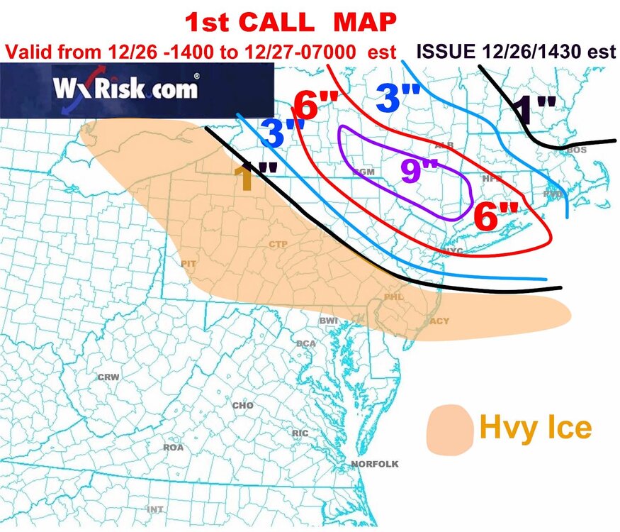
26th-27th event, coming at us like a wounded duck.
ineedsnow replied to Go Kart Mozart's topic in New England
NAM!!!! -
I love how they accounted for the inevitable under measurement for CPB with the blue stripe.
-

26th-27th event, coming at us like a wounded duck.
40/70 Benchmark replied to Go Kart Mozart's topic in New England
Sey-Mour Sleet -

26th-27th event, coming at us like a wounded duck.
CoastalWx replied to Go Kart Mozart's topic in New England
Haven’t looked yet. We eat and drink. -

26th-27th event, coming at us like a wounded duck.
Baroclinic Zone replied to Go Kart Mozart's topic in New England
Track yes, but I think we will see a broader expansion of snow on the NE side of the storm. -
Absolutely. Short range models like the NAM have a knack for noticing this stuff. And it wouldn’t really be a shock for a SWFE to be mainly sleet for our area, would it? That’s how it usually goes
-

26th-27th event, coming at us like a wounded duck.
Ginx snewx replied to Go Kart Mozart's topic in New England
What's Drag say? -
Im right by you in Morristown; also that map from DT isn’t one of his worst. lol
-

26th-27th event, coming at us like a wounded duck.
Sey-Mour Snow replied to Go Kart Mozart's topic in New England
All the lean on ensembles has been SW, I think it’s reached its NE limit -

Occasional Thoughts on Climate Change
WolfStock1 replied to donsutherland1's topic in Climate Change
Weather vs Climate. When looking at climate looking at single month, or even a single year, is meaningless - it's noise. You have to look at multi-year or even multi-decade averages to determine what's really going on. -

Boxing Night Snow/Sleet/Ice Dec 26-27 Storm Thread/Obs.
penndotguy replied to Mikeymac5306's topic in Philadelphia Region
No doubt, it’s been an early start and trust me I’m not complaining at all about the snow so far I’ll take whatever we can get, but man it would be great to have a true classic snowstorm, been awhile -
26th-27th event, coming at us like a wounded duck.
Baroclinic Zone replied to Go Kart Mozart's topic in New England
I’m not sold on any trend back S and W. There has been a trend for a relaxing thin the confluence to the NE and also seeing some consolidation of the s/w energy. That 18z NAM is a thumper dumper. -

Boxing Night Snow/Sleet/Ice Dec 26-27 Storm Thread/Obs.
RedSky replied to Mikeymac5306's topic in Philadelphia Region
.30" of precip isn't going to be much sleet -
DT
-

Central PA Winter 25/26 Discussion and Obs
Ruin replied to MAG5035's topic in Upstate New York/Pennsylvania
I s talking models period. I've seen euro nam etc go from a full out blizzard to flurries in 1 run to the next 2 days out -
Probably gonna be some big parachute flakes as the sleet line approaches with flakes sticking together in the near freezing 700mb layer.. especially if winds aren't too strong.
-
This should be the real deal as we get into Jan,should see a change after that trough moves east,this cold spell is nothing but transient right now,you could possibly be fixing to see a more substantial one afterwards
-
Central PA Winter 25/26 Discussion and Obs
Ruin replied to MAG5035's topic in Upstate New York/Pennsylvania
Abc27 did the same starting it now at 4pm and it ends like at 5 am. Showed very spotty too. -

December 2025 Short/Medium Range Forecast Thread
Holston_River_Rambler replied to John1122's topic in Tennessee Valley
Merry Christmas! -

26th-27th event, coming at us like a wounded duck.
weatherwiz replied to Go Kart Mozart's topic in New England
It's very possible. If there is any setup that the NAM is going to outperform other guidance it is going to be this. The globals aren't particularly skillful when it comes to banding. In terms of other mesos, I don't even think the HRRR handles that well. The best thing I think to do is forget QPF amounts and QPF trends and using those to define the storm trends. The focus and assessment should be on the mid-levels and particularly that mid-level warm front. Often, models will produce the heaviest QPF right under directly under where the best dynamics or fronto or gradient is but more time than not the heaviest QPF is going to be displaced a bit north of this. -
I am in a warning now 4 - 8. I feel good about 6 here and if some ratios work out maybe an extra puff to get closer to 8. I’ll sign for 6 though.
-
It's cool to see solidly subfreezing temperatures in place for an event for a change. It looks downright cold in the lower Hudson valley tomorrow. It should transform the landscape no matter what wintry precip. falls.
-
Congrats on the move
-
I fly in there all the time. Its not a matter of getting in anymore in 2025 with the airlines. It is social media publicity and liability. Big storm headed to NY area with a double digit snowfall possible? The airline is going to shutdown ops hours early and stay closed til the next day. 100% sure that cancels.
-
[emoji817] I loved seeing the snow fall on Tuesday morning because of that. We had a few inches of snow in MMU Tuesday morning, it coated the trees, it fell heavily for a few hours, and it calmed me and made me happy right before Christmas. What else could you ask for as someone who likes snowstorms? .


