All Activity
- Past hour
-
 DCA and IAD have officially gone over to Broken from Overcast. I'm up over 200 w/m2 solar like some of the mesonet sites.
 -
.thumb.jpg.6a4895b2a43f87359e4e7d04a6fa0d14.jpg)
Central PA Spring 2026 Discussion/Obs Thread
Yardstickgozinya replied to Voyager's topic in Upstate New York/Pennsylvania
Nah, there's a lot of places like that, same with these YouTube. Idiots like Ryan hall and Max velocity. They're f****** up everything. -
 Sun weakly shining in south Arlington.
 -
That is awful to hear... he was a very nice guy and I had many great conversations with him over the years here. May he rest in piece.
-
That sucks man, we lucked out ended up with 10-12" of concrete again which I will gladly take. Looks like its a little less ice than last year but still a mess. Hope you get your power back soon, last year I was out for over 10 days.
-

Pittsburgh/Western PA WINTER ‘25/‘26
colonel717 replied to Burghblizz's topic in Upstate New York/Pennsylvania
-

Central PA Spring 2026 Discussion/Obs Thread
pasnownut replied to Voyager's topic in Upstate New York/Pennsylvania
fill in the blanks and tell us how ya really feel what they do serves no useful purpose except to drive traffic to their page. -
Heard from someone that her kids' Loudoun County school will close 3 hours early. Still not posted on LCPS, WUSA or WJLA websites.
-
Central PA Spring 2026 Discussion/Obs Thread
Yardstickgozinya replied to Voyager's topic in Upstate New York/Pennsylvania
I'll make 80 different accounts until they change their f****** ways. Even if it takes me a year and nine months, just like it did here. That's why they couldn't accept any members.here for nearly a year few years ago. They told everybody it was a server issue.What a lot of people probably don't know Is that was actually just to keep me out because I would a f****** torn this place to pieces until the moderators changed their ways. -
 If anything the radar seems encouraging. Lots of the showers/storms, even while weak, are attempting to spin. We just have to see if a storm gets strong enough to take advantage.
 -
Central PA Spring 2026 Discussion/Obs Thread
pasnownut replied to Voyager's topic in Upstate New York/Pennsylvania
On way up to cabin Friday night, once we got to wellsboro, it started to snow, and by the time we got to Tyoga Country club, it was easily the hardest snow I've seen this year. Huge flakes, and from there to Ansonia was a crawl. Up on top at cabin ended up w/ 1-2" depending on where you were. Cut wood saturday morning in a snow covered landscape. Was nice. regarding today, yeah its been showing up consistently on some models and I'd think NC and NE Pa stand best chances for some late season shenanigans. hoping we stay cloudy long enough to mitigate sever to just a nice squall line w/ Tboomers -
 Sun out in Rockville. Visible satellite showing some legit breaks in the clouds.
- 380 replies
-
- 2
-

-

-
- severe
- thunderstorms
- (and 1 more)
-

Spring 2026 Pattern Discussion Thread
Holston_River_Rambler replied to Carvers Gap's topic in Tennessee Valley
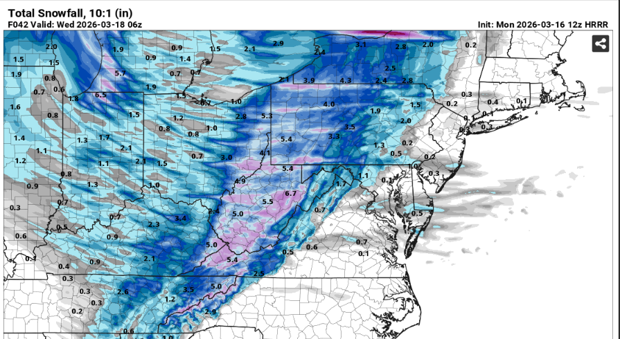
12z HRRR just had a conniption over the Smokies -
So is that thunder coming on board in S CT? Looks like it's warm frontal thrust/lifting edge
-
Obviously measuring will be a nightmare, but guessing 4-5" IMBY. Pretty legit in the open areas with wind whipped snow.
-
 I know where my money is. The same weenies called for a complete bust the other day when we were cloudy early on.
- 380 replies
-
- 1
-

-
- severe
- thunderstorms
- (and 1 more)
-
 64/62 sun peaking out
 -
Charlotte Tornado warning i think Goldsboro to Triangle area will be the area with the highest chance of seeing something today. Seems like that is normal area for these type of events.
-
Central PA Spring 2026 Discussion/Obs Thread
Yardstickgozinya replied to Voyager's topic in Upstate New York/Pennsylvania
Who are these b**** a** m************ people? I'll make a Facebook account just to go over and make their f****** lives miserable. I can't stand s*** like that internet Hype f****** p***** c*** b****** p*****me off more than any m*********** can even f****** understand. -
Central PA Spring 2026 Discussion/Obs Thread
pasnownut replied to Voyager's topic in Upstate New York/Pennsylvania
While i've not gotten the levels of grief that you have, whenever they as me about weather here, I just say "its up in the air". They give cockeyed stare but most know why I do it. -
 Mets in here talking about the exceptional conditions and the normal weenies come in saying Meh. Hmm, who will be right?
 -
yeah, today has downer murk look for a week's worth of guidance approaching. the high pressure is retreating due E keeps the SEsties in a moist/saturated flow. The warm front comes through later.
-
It does look like that. I had hope with the favorable MJO and teleconnections. I will continue to track but it doesnt look good like it did earlier this month.