All Activity
- Past hour
-

Jan 24-26 Weekend Snow and Sleetfest Model Thread Part Tres
EHoffman replied to H2O's topic in Mid Atlantic
I mean you can just take a look at the radar and it's obvious that's sleet falling all through southern OK. -

“Cory’s in LA! Let’s MECS!” Jan. 24-26 Disco
78Blizzard replied to TheSnowman's topic in New England
Yup. -

Jan 24-26 Weekend Snow and Sleetfest Model Thread Part Tres
HighStakes replied to H2O's topic in Mid Atlantic
9. -

Jan 24-26 Weekend Snow and Sleetfest Model Thread Part Tres
jayyy replied to H2O's topic in Mid Atlantic
Banding perhaps? but yeah, likely not the case. -

“Cory’s in LA! Let’s MECS!” Jan. 24-26 Disco
40/70 Benchmark replied to TheSnowman's topic in New England
Not that there is anything wrong with that...Like Jerry said, it's a pummeling. -

Jan 24-26 Weekend Snow and Sleetfest Model Thread Part Tres
LVblizzard replied to H2O's topic in Mid Atlantic
Look at mPING as it relies on actual observations, not the colors on radar maps. It currently has sleet up to Ada, OK, right in line with the Euro and HRRR. It does appear the NAM was too warm at the mid levels, though, as it had sleet up to I-40 where it’s currently all snow. -

Central PA Winter 25/26 Discussion and Obs
Itstrainingtime replied to MAG5035's topic in Upstate New York/Pennsylvania
...and the GGEM looks good. -

Pittsburgh/Western PA WINTER ‘25/‘26
colonel717 replied to Burghblizz's topic in Upstate New York/Pennsylvania
With all the new and extra data we had the great results from all models. Good to see that extra sampling didn't go the other way. -
Awesome, now let us know when the exploding tree temperature threshold is!
-

Jan 24-26 Weekend Snow and Sleetfest Model Thread Part Tres
konksw replied to H2O's topic in Mid Atlantic
18.5/-9.1 -
“Cory’s in LA! Let’s MECS!” Jan. 24-26 Disco
78Blizzard replied to TheSnowman's topic in New England
Agree. -
“Cory’s in LA! Let’s MECS!” Jan. 24-26 Disco
40/70 Benchmark replied to TheSnowman's topic in New England
F5 has had that issue in the past, too...they seem to have rectified it. -
“Cory’s in LA! Let’s MECS!” Jan. 24-26 Disco
40/70 Benchmark replied to TheSnowman's topic in New England
Cool, 26" for all....you do you. Looks like 16-21" to me. -

“Cory’s in LA! Let’s MECS!” Jan. 24-26 Disco
weathafella replied to TheSnowman's topic in New England
Point is, uncle is a pummeling but it is late Friday night and crazy uncle. -
Honestly? At start of this week, if you would have told me 3”-6” I would have been very happy. BTV always seems pretty level headed so I usually trust them. But you know your stuff too so I can see what you’re saying.
-

Jan 24-26 Weekend Snow and Sleetfest Model Thread Part Tres
Random Chaos replied to H2O's topic in Mid Atlantic
22.2/6.0 winds gusting to 32mph -
21/3 out here in Romancoke on Kent Island .
-
Already down to 17F w/a -6F dewpoint and 1F windchill at IAD. It be COLD.
-

Pittsburgh/Western PA WINTER ‘25/‘26
Rd9108 replied to Burghblizz's topic in Upstate New York/Pennsylvania
-
“Cory’s in LA! Let’s MECS!” Jan. 24-26 Disco
weathafella replied to TheSnowman's topic in New England
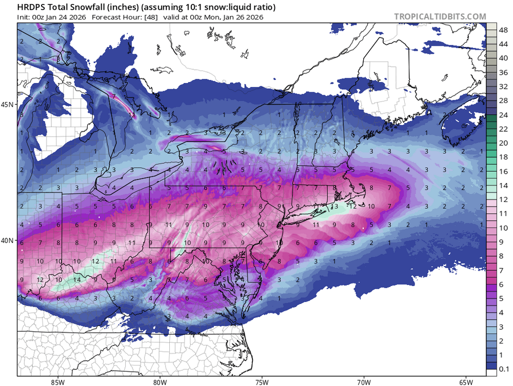
They match 10:1 pretty closely this time. Match the qpf. The dark blue is 15”, the mauve is 18”, redder 21”. There’s a 2” qpf stripe that matches that frim BOS to part of the south shore. -
“Cory’s in LA! Let’s MECS!” Jan. 24-26 Disco
78Blizzard replied to TheSnowman's topic in New England
I noted earlier that there is something wrong with Pivotal's 10-1 ratio on both the 18z and 0z runs for the Ukie, at least. The 10-1 snowfall total doesn't correspond with the qpf. -

Jan 24-26 Weekend Snow and Sleetfest Model Thread Part Tres
pazzo83 replied to H2O's topic in Mid Atlantic
18/-6 - definitely one of the lowest dewpoints I've seen. -
we are so back!
-
January 2026 regional war/obs/disco thread
40/70 Benchmark replied to Baroclinic Zone's topic in New England
Well 18z GEFS were just se of the BM....so not necessarily. -
We fr live in a society


