All Activity
- Past hour
-
That 99 in 1983 tied 1931 (Sep 11) but yes it was the latest in season. The next benchmarks are 97F on Sep 23, 1895 and 94F Oct 5, 1941, 91F Oct 10, 1939, and 90F Oct 17, 1938. Benchmarks after that are Oct 22 1979 (88F), Oct 23, 1947 (85F), Nov 1 and 2 1950 (84F, 83F), Nov 15 1993 (80F), Nov 20, 1985 (77F) , Dec 7 1998 (75F) and possibly Dec 24 2015 (72F). (a benchmark as you probably know is a latest occurrence in season, or an earliest from midwinter to midsummer). Benchmarks before the 1881 101F are (by definition) the all-time record 106F July 9, 1936, then 104F Aug 7, 1918, 103F Aug 26, 1948 and 102F Sep 2, 1953, 101F Sep 7, 1881. 2015 (Dec 24) at 72F is a partially invalid benchmark as it was also 72F on Jan 6, 2007 and Jan 26, 1950. These are probably the real benchmarks eliminating Dec 24, 2015 but another view would be only Jan 25, 1950 is a benchmark (falling) because the coldest day of winter is on average in early February. This is when the benchmarks reverse, so the set of spring into summer benchmarks are 73F (Feb 15, 1949), 78F Feb 21, 2018, 79F Mar 10, 2016, 85F Mar 13, 1990, 86F Mar 29, 1945, 92F Apr 7, 2010; 96F Apr 17, 2002; 99F May 19, 1962; 100F June 26, 1952, 101F June 27, 1966, and 103F July 3, 1966 before the ultimate 106F July 9, 1936. These are the only daily records that "really matter" in the sense that all others are not as impressive in terms of being earliest or latest occurrences. It's interesting how few of these are recent. If you only count the 72F in Jan 1950, then there are 29 benchmarks (one tied 1931,1983, and two cases of two consecutive in same year 1950 and 1966) and the median of the 26 years involved (1950 counts three times, 1966 twice) is 1952. The years counted are 1881 1895 1918 1931 1936 1938 1939 1941 1945 1947 1948 1950** 1952 1953 1962 1966* 1979 1983 1985 1990 1993 1998 2002 2010 (2007, 2015 not counted) 2016 2018 ... The benchmarks cluster noticeably from 1936 to 1953 (12 of 29), and 1979 to 2002 (7 more). There is no significant bias towards recent decades, with 29 benchmarks over 156 years, one would expect 4 since 2000 which is the case. The number established by 1918 (3) is well below random expectation (9). The only year with two non-consecutive benchmarks from the same spell of weather is 1950 (one in January, two in early November). But if Dec 2015 counted, the two closest in time (non-associated) would be that one and March 10, 2016. I'm not sure what name you could give an almost-benchmark, which would be a case like April 18, 1976, tying a benchmark and clearly a near-equal outlier (86F Mar 31 1998 would be another, as would 94F on Sep 23, 1914). I guess almost-benchmark is probably as good as we'll get. A benchmark can be erased as even a daily record, for example, April 7, 1929 (89F) was a benchmark until 2010 replaced it as both a daily record and benchmark. 1991 held a 90F benchmark set April 8, that one is still a daily record but was removed as a benchmark by 2010. May is the only month with only one benchmark. That is a sign of the extreme significance of the 1976 and 2002 April 96 readings, no date in early to mid-May exceeded them (before 1962, the benchmarks were 92F (Apr 27, 1915), 93F (May 12, 1881), 95F (May 25, 1880), 96F (May 31 1895, 1939) and 99F (June 4, 1925).
-
Had that here on June 24, 106.0 and 102.6 the day after. Beat my July 22, 2011 mark at the same location which was 105.6
-
For comparison it’s 66 degrees and cloudy in Boston now with a northeast wind
-

2025-2026 ENSO
Stormchaserchuck1 replied to 40/70 Benchmark's topic in Weather Forecasting and Discussion
I would think so.. maybe someone can has a Twitter thread or something. 42c is 107F. -
Eflin lol. Put him on IR. Throwing batting practice.
-
I wonder if this is record max heat for Paris?
-
Sun never even considered coming out today. Fog and mist all day after the morning deluge. Just another craptastic Saturday all around.
-
2025-2026 ENSO
Stormchaserchuck1 replied to 40/70 Benchmark's topic in Weather Forecasting and Discussion
Looks like it maxes out over France.. I bet bluewaves 500mb anomaly record maps show historic ridging there. -
This was all your doing, Santa Claus!! Christmas in June (in more ways than one too!!)
-
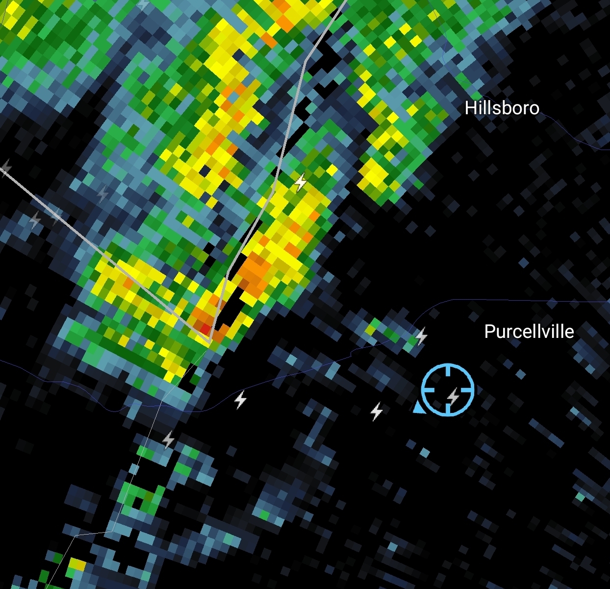
Line formed in Adams County and dropped into Carroll before dying near Westminster.
-
breezy enough
-
Ravens tied with the Eagles and Bills for #1 super bowl odds currently! Bills don't have WR's, so I don't know why they are so high.. probably a weak division. Eagles have so much talent on that team, I would place them at number 1.. but the Ravens really improved their defense this offseason, and extended Derrick Henry and Bateman, which means they are probably doing good.
-
has his own mod-ordained thread, total and complete libertybell victory, haters in absolute ruins right now
-
anything near as historic as the 40C London experienced a few years ago?
-
 roses for Alek joined the community
 -
It will turn even warmer tomorrow. Tomorrow and Monday will likely see temperature reach the middle and perhaps upper 80s in New York City. Tuesday could top out near 90°. Newark could be near or just above 90° on each day during this peirod. In addition, there will be a risk of a shower or thundershower during the weekend. Excessive heat does not appear likely to return through at least the first week of July. However, there is somewhat less certainty than yesterday. Both the 12z GFS and ECMWF show potential for more significant heat during the July 6-8 period. The ENSO Region 1+2 anomaly was +1.0°C and the Region 3.4 anomaly was 0.2°C for the week centered around June 18. For the past six weeks, the ENSO Region 1+2 anomaly has averaged +0.47°C and the ENSO Region 3.4 anomaly has averaged -0.03°C. Neutral ENSO conditions will likely continue through at least late summer. The SOI was +2.81 yesterday. The preliminary Arctic Oscillation (AO) was +1.124 today. Based on sensitivity analysis applied to the latest guidance, there is an implied near 100% probability that New York City will have a warmer than normal June (1991-2020 normal). June will likely finish with a mean temperature near 73.2° (1.2° above normal).
-
It's been incredible to see how the rain and storms have danced around my area this week. Only caught a few passing sprinkles as storms fired close and died out as they reached me. The high rain chances for today and tomorrow have faded too.
-
2025 Atlantic Hurricane Season
Stormchaserchuck1 replied to BarryStantonGBP's topic in Tropical Headquarters
A bit of a reverse-Atlantic tripole SST pattern, which at this time of the year has a pretty strong correlation with later in the season. I'm actually surprised that surface SSTs have such a strong correlation with hurricanes compared to other factors, but the most active years minus least active years show this clearly. -
Looks like the negative momentum is back. Not sure they have another comeback in em.
-
83/71 now, 85 earlier. Beautiful day
-
2025-2026 ENSO
Stormchaserchuck1 replied to 40/70 Benchmark's topic in Weather Forecasting and Discussion
Strong +NAO driven heat wave for Europe. 595dm making it to Paris, France -
Well it all collapsed. I might get .05” maybe - it’s a heavy sprinkle.
-
It feels weird to sit outside on a Saturday crushing beers without rain
-

July 2025 Obs/Disco ... possible historic month for heat
Cyclone-68 replied to Typhoon Tip's topic in New England
“The July 1st Outbreak” has a good tone to it -

July 2025 Obs/Disco ... possible historic month for heat
Torch Tiger replied to Typhoon Tip's topic in New England
Yeah, hopefully Tuesday works out. -
I was out mowing and that storm was pretty far away when a bolt hit right next to my neighbor's home. Wild. I stopped mowing. The storms were even further than when I took this screen grab. Blue sunny sky with storm clouds a bit in the distance. Got my attention!! Lol