All Activity
- Past hour
-

Central PA Winter 25/26 Discussion and Obs
Blizzard of 93 replied to MAG5035's topic in Upstate New York/Pennsylvania
The end is our friend in CTP … Long way to go, but good to see the Ops at 12z all showing a storm in our region this run. Details TBD…
-
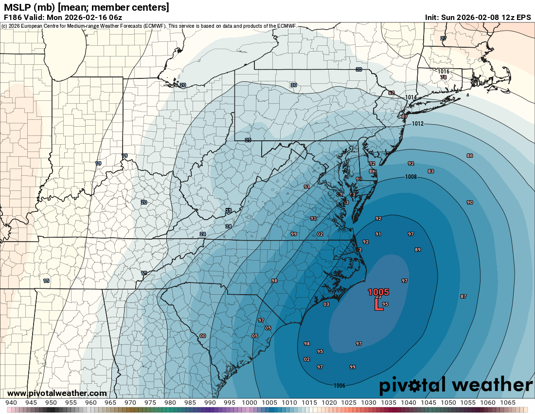
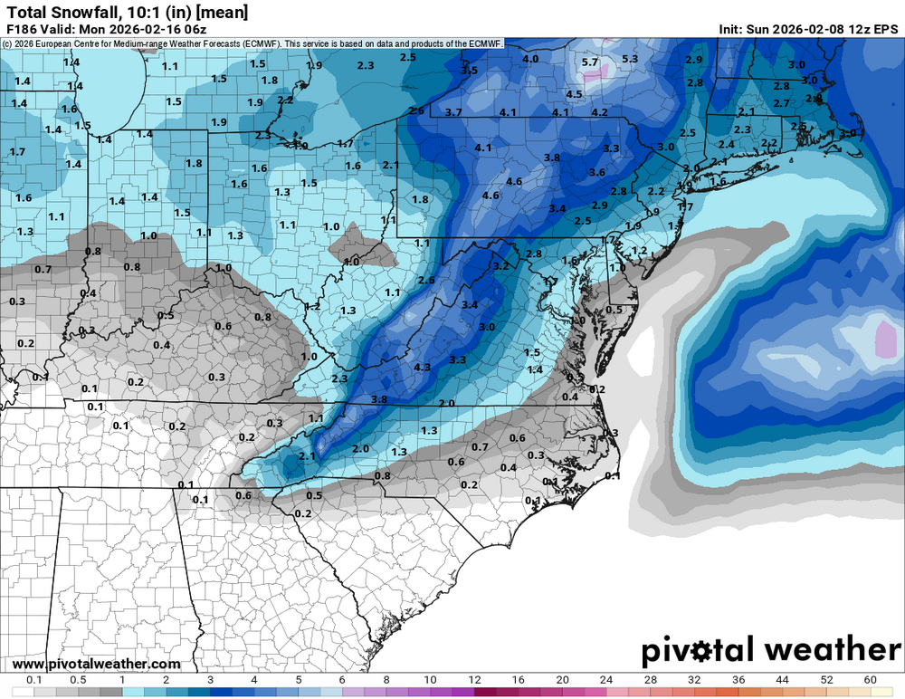
12z EPS...
-
Euro has a great track for us this afternoon for V-Day,just no cold to work with and the CF dont even look very impressive with cold behind it,,looks like another swing and a miss for us here this winter,still 7 days out so it could very well change.
-
 The pendulum continues!
-
 Low positions on the EPS aren't bad. You can see how the operational euro was well NW of this mean. Temps marginal, better for NW, like the rest of the 12z of all models. Well, I've been reeled in by the trends of the last 4 runs; time to pay attention for the next day or two
-
Central PA Winter 25/26 Discussion and Obs
Blizzard of 93 replied to MAG5035's topic in Upstate New York/Pennsylvania
-
The air has only gotten drier in Triad. The current dewpoint is -3°.
-
I’m sure she’s been telling you that every time but that doesn’t mean it’s true
-
 AIFS ens are close…
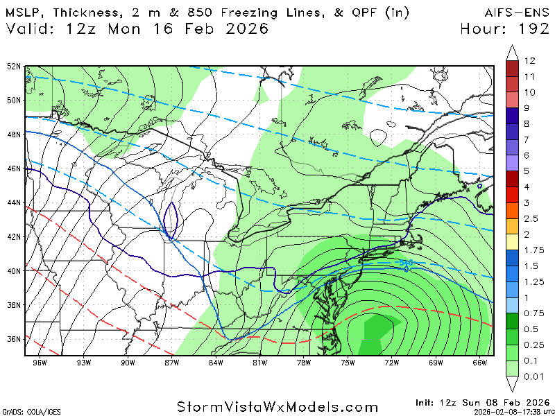
-
Southern stream system riding the southern border to the GOM with room to amplify…yeah keep that a little south at this point.
-

Central PA Winter 25/26 Discussion and Obs
canderson replied to MAG5035's topic in Upstate New York/Pennsylvania
Yea it’s a margin thin event in multiple ways but it’s not impossible to get some snow out of it. The snow will take a hit this week so would be nice. -

E PA/NJ/DE Winter 2025-26 Obs/Discussion
Duca892 replied to LVblizzard's topic in Philadelphia Region
Just checking GFS 12Z back on for next week?? -

Central PA Winter 25/26 Discussion and Obs
Itstrainingtime replied to MAG5035's topic in Upstate New York/Pennsylvania
It rained 6"+ of snow on my house, troll. -
Central PA Winter 25/26 Discussion and Obs
Blizzard of 93 replied to MAG5035's topic in Upstate New York/Pennsylvania
Fake fake news. Every model snows on us next weekend at least to start. -
 I don’t know what to think anymore…hence the reason I said scientific research is needed lol. Is it too warm? Well it’s been pretty cold. Is it too dry? Well we had 2” of qpf from our snowcrete event. Are we just too far south? Well Charlotte got 10” recently and Roanoke is the new snow capital of our region lol. I still think the main issue is that it’s just been too dry overall…simply not enough chances to even get a storm. So if that’s due to a Nina, then it’s been very pervasive the last few years.
 -
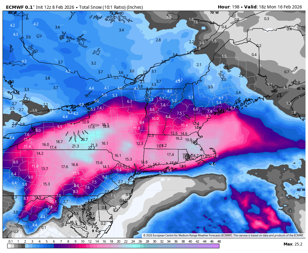
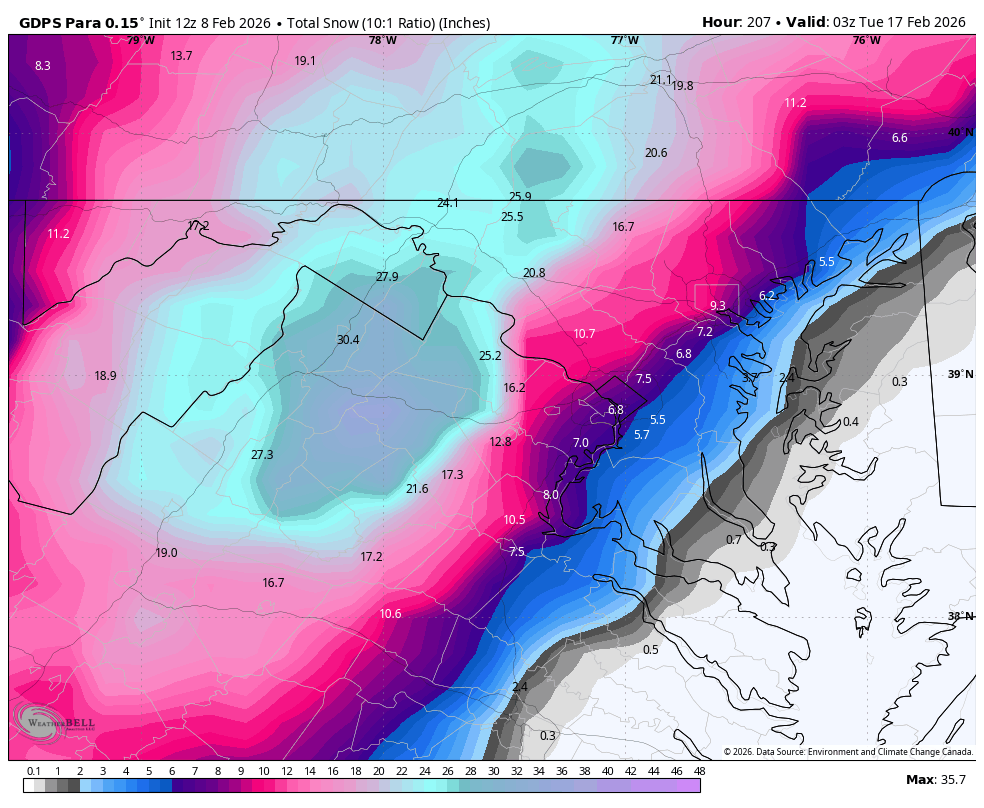
 What a gradient!
 -
Central PA Winter 25/26 Discussion and Obs
Itstrainingtime replied to MAG5035's topic in Upstate New York/Pennsylvania
We got snow from them but it's an incredibly tenuous situation that has low probabilities. Definitely worth watching. -
Winter Storm Threat *Technical* Discussion. No Op Run PBP or Snow maps
Climate175 replied to CAPE's topic in Mid Atlantic
I believe this was a smart idea. As we can see with the response to the 12z Euro, we need a place to read analysis without the volatile reactions LOL. -
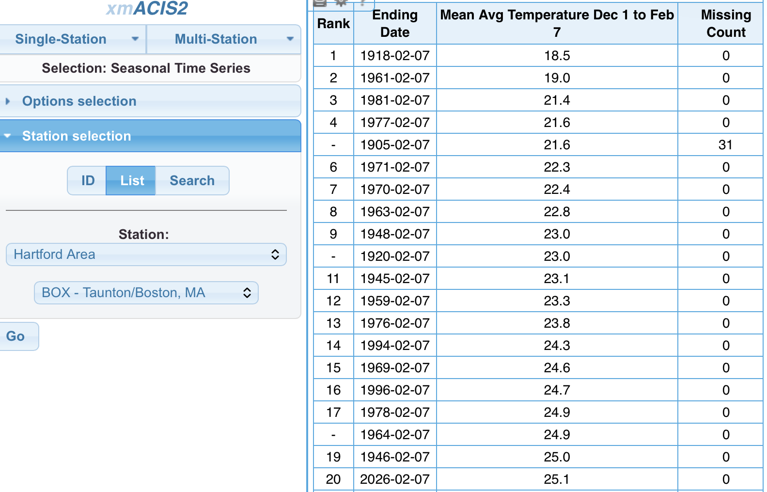
 That’s pretty damn good. I subtracted out 1904-05 that was missing December. It’s tough to compete with yore and that 60s-80s period.
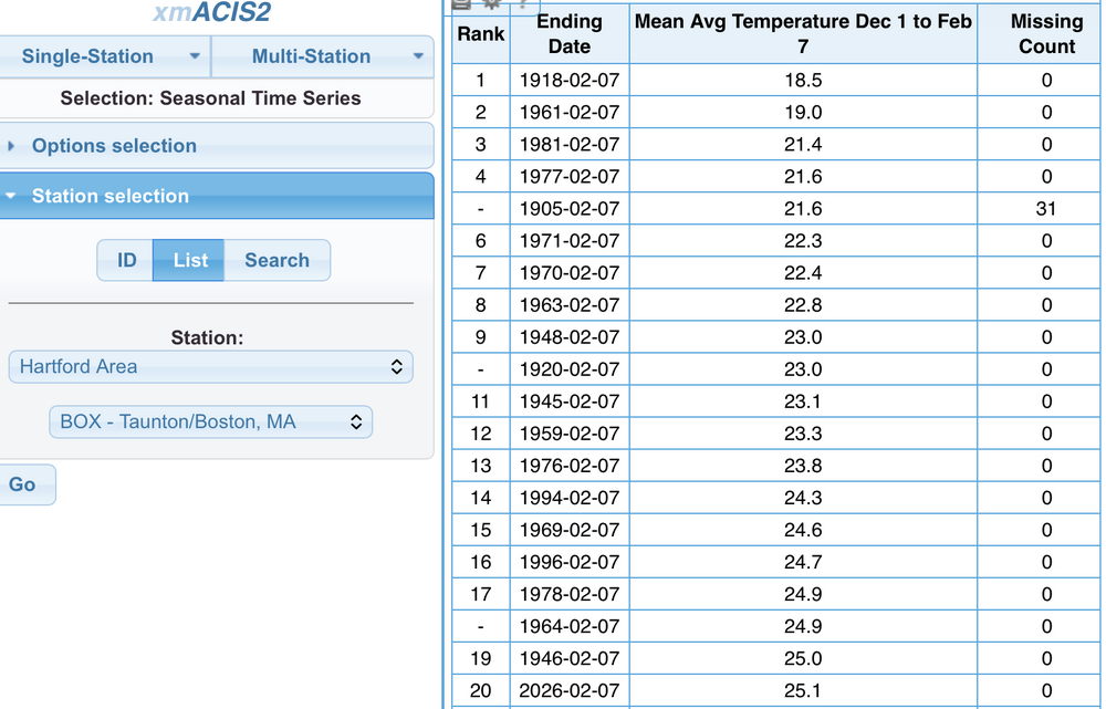
-

E PA/NJ/DE Winter 2025-26 Obs/Discussion
Birds~69 replied to LVblizzard's topic in Philadelphia Region
Hopefully it means a continued cold winter which will extend well into late Spring followed by double digit below normal temps during Summer with clouds and rain most of time... 14f -
Central PA Winter 25/26 Discussion and Obs
Itstrainingtime replied to MAG5035's topic in Upstate New York/Pennsylvania
Someone please get this guy out of here. -
 If Dr. No gives us a flush hit, the board will crash!
 -
Heather Archambault About me: http://www.met.nps.edu/~hmarcham/images/me.jpg In September 2011, I began a postdoc with Profs. Pat Harr and Rich Moore in the Department of Meteorology at the Naval Postgraduate School in Monterey, CA. Before coming to NPS, I earned my Ph.D. and M.S. in Atmospheric Science from the University at Albany, where I was advised by Profs. Dan Keyser and Lance Bosart. My Ph.D. dissertation on the downstream extratropical flow response to recurving western North Pacific tropical cyclones can be accessed here. For my M.S. thesis, I examined statistical and synoptic-dynamic relationships between major cool-season Northeast precipitation events and North Atlantic Oscillation and Pacific–North American regime transitions. Two journal articles describing this work are available here and here. I received a B.S. in Meteorology from Penn State University. My research interests span a variety of topics in synoptic–dynamic meteorology. I am especially interested in the dynamics and predictabilty of tropical–extratropical interactions that serve as precursors to remote high-impact weather events such as heat waves, severe weather outbreaks, or winter storms. In my free time, I like to hike, bike, experience California's microclimates, listen to or attempt to make music, spend time in cafes (especially for brunch), watch anything featuring anyone from the "The State", play or watch basketball, pore over the New York Times online, travel, see movies, and spend time with family.

-
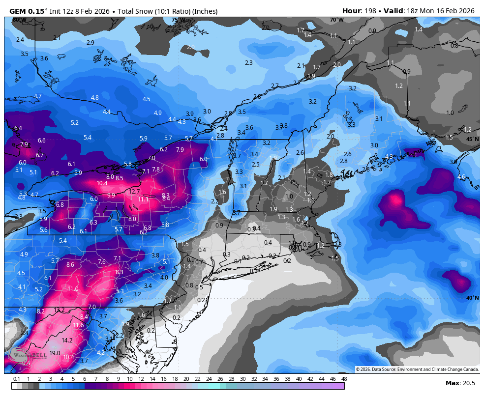
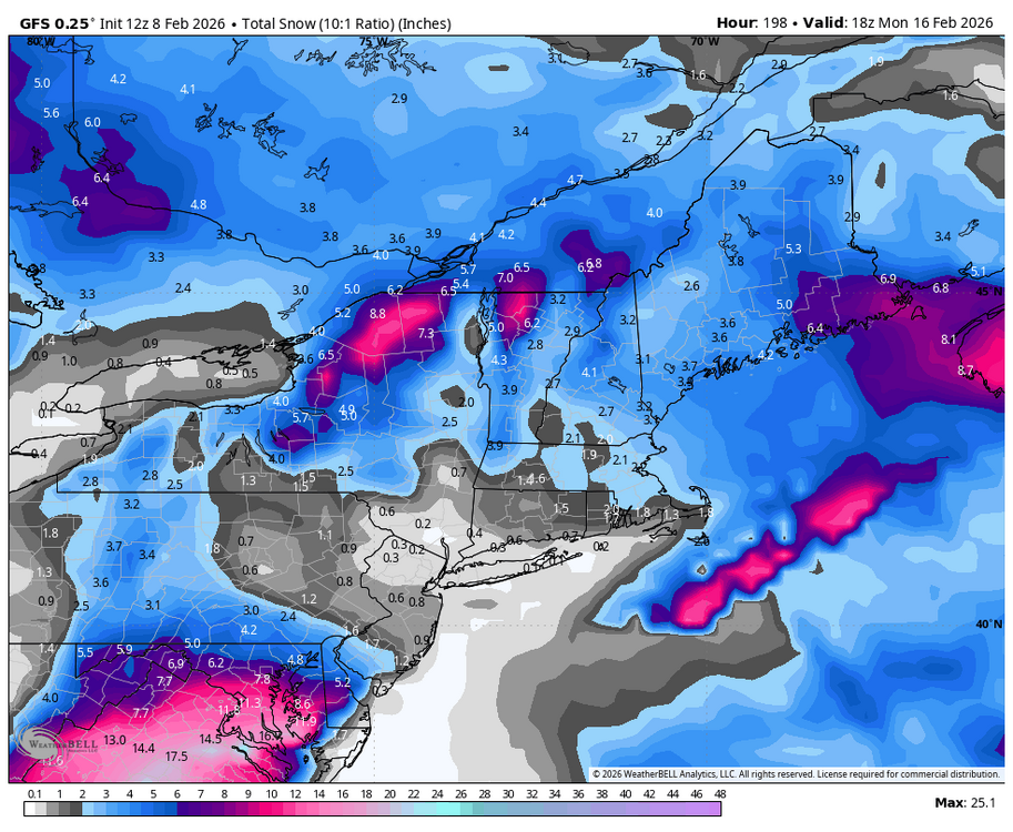
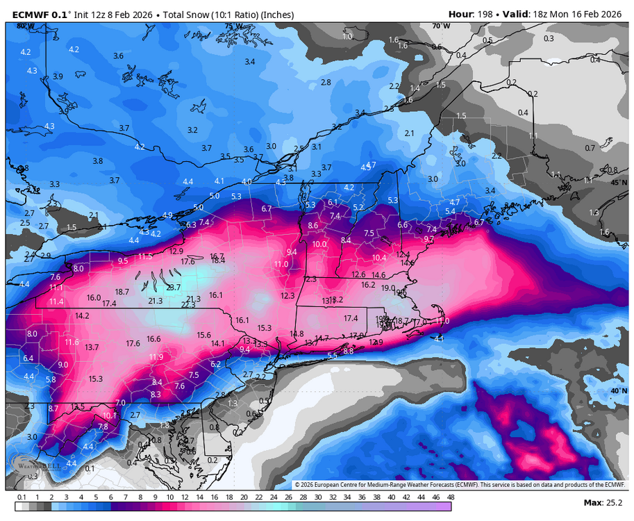
CMC Para 10:1 (paste bomb so Kuchera hates it)

-
How much for Philly?