All Activity
- Past hour
-

November 2025 general discussions and probable topic derailings ...
WinterWolf replied to Typhoon Tip's topic in New England
Isn’t the median the middle, and the mean is the average? -
I guess there could be some sleet at the onset (GFS) ahead of the rain on the Tuesday before Thanksgiving in the northern suburbs. Otherwise not much wintry to track for the moment. Hope it changes for the better soon.
-
Quite a few but the last couple el ninos sucked even worse TBH
-
What about the past 20
-
 Beerdian vs beer?
 -
Agreed. Here they changed fast and nearly all the trees lost their leaves at the same time. Made cleaning up nice for a change instead of doing it weekly for like 6 weeks. I only did one big cleanup last week, and tomorrow ill do a mow/mulch of what's left.
-

November 2025 general discussions and probable topic derailings ...
dendrite replied to Typhoon Tip's topic in New England
Mode? -
 Chinook changed their profile photo
 -
Good news is the pacific doesn’t look as F’d as it did a few days ago. PNA Pretty much stays neutral now. That’s always the first place I look. As for the SER, as long as we don’t get that big western trough it can be beat back. A La Niña paired with a negative PNA is a death sentence for the southeast winter lovers
-

E PA/NJ/DE Autumn 2025 Obs/Discussion
simbasad2 replied to PhiEaglesfan712's topic in Philadelphia Region
There was actually some pretty decent ensemble support earlier this week of an amplified shortwave to emerge behind the Thanksgiving system around the weekend of 11/29-30. Unfortunately this looks unlikely now -

Fall 2025 Medium/Long Range Discussion
ChiTownSnow replied to Chicago Storm's topic in Lakes/Ohio Valley
@Chicago Storm we need your mid range pattern analysis posts.. seems pattern change is immenet come end of month. -

2025-2026 ENSO
brooklynwx99 replied to 40/70 Benchmark's topic in Weather Forecasting and Discussion
honest question, is it possible for models in the 1-2 week range to show a pattern that you will actually get excited about? -
34 here, low was 30.2, second freeze of the season. Peppers look unhappy but otherwise alive. They didn’t flinch at the first freeze (31.6) on 11/7.
-

December 2025 Short/Medium Range Forecast Thread
jaxjagman replied to John1122's topic in Tennessee Valley
Cool,he finally got this running again.thumb.png.8754ab3f849d107be4ed22622bf61488.png)
-
The colors seemed muted this year too, due to the drought.
-

November 2025 general discussions and probable topic derailings ...
Torch Tiger replied to Typhoon Tip's topic in New England
median vs. mean. -
is this a pattern issue or is this just a warm/wet cold/dry mantra? i would somewhat agree with the assertion of warm/wet cold/dry winters, however i would disagree when saying that the patterns itself have been bad. it's just that the good patterns didn't produce. please correct me if i'm wrong.
- Today
-
The pattern never developed which could have produced a KU. That’s why it didn’t happen. Need the Pacific Jet to relax for storm tracks like that.
-
It is dead still outside. Makes 45 degrees seem kind of nice.
-
tacoman - thanks very much for your post, and good information you shared. I probably went off the deep end a bit due to my frustration over the anemic pattern we've been in. I hope you're right that it changes soon!
-
We didnt get a KU would be the answer, so grrr bad!
-
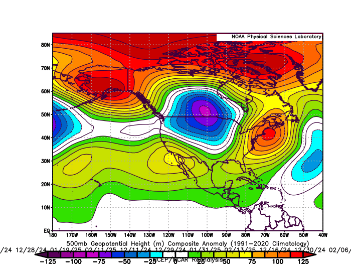
This is the actual 500mb pattern last winter on the 11 days which .20 or more of precipitation fell from Philly to Boston. Very fast extended Pacific Jet along with a Southeast ridge linking up with the Greenland block with a warm storm track through the Great Lakes. So the NYC average temperature last winter during the days with the heavier precipitation was 41° which was too warm to reach anywhere near average seasonal snowfall. Long range models consistently missed this pattern beyond 1 week out. Has nothing to due with luck or Monday morning quarterbacking. The storm track is a function of the pattern. I still think it’s possible to change things up a bit. But I am not going to make that forecast based on a week 2 or 3 model forecast. It has to show up in the short term in order to be believable. 11 day 500 mb composite DJF 24-25 when .20 of precipitation fell from Philly to Boston
-
The Washington DC Metropolitan Region will get beneficial rains from the system that just missed us. You guys are downstream of us and will benefit from this weather system as it continues to develop as it translates E/NE with time. Another rainmaker will help Washington out right after that. Same reason come December/January/February you will see snows from the intersection of moisture contributions from Texas and the Gulf of Mexico and cold air. Our misses and failures will become YOUR BIG STORM DIRECT HITS ON YOUR ENTIRE SUB this entire winter! First beneficial rains, later translating into really good snows that will pile up and wear out your backs as you will be forced to dig snow after snow after snow!
-
2025-2026 ENSO
brooklynwx99 replied to 40/70 Benchmark's topic in Weather Forecasting and Discussion
sure, we can play Monday morning QB and say "nooooo those patterns were actually bad because they didn't produce snow!" but that's disingenuous -
2025-2026 ENSO
brooklynwx99 replied to 40/70 Benchmark's topic in Weather Forecasting and Discussion
not to harp on last year, but models actually did a good job showing the amount of high latitude blocking that developed. to say that a good pattern never developed is just incorrect
-
The storm track pattern most of the time since 2018-2019 has been Great Lakes cutter, I-78 to I-84 hugger, and suppressed Southern Stream. This has been a result of the record WPAC warmth both in the subtropics and midlatitudes with a much faster Northern Stream of the Pacific Jet along the thermal gradient between the Siberian cold and WPAC to south of Aleutians warmth. Storm track #1 features a trough in the West and a Southeast ridge. So the low deepens crossing the Great Lakes with a warm storm track and mostly rain along the I-95 corridor from DC to Boston. Track# 2 features poor wavelength spacing in the fast Pacific flow so the storm hugs the I-78 to I-84 corridor favoring the interior regions away from the coast for the heaviest snows. Both these tracks feature too strong of a Southeast Ridge. Track #3 has a kicker low coming into Western North America in the fast Pacific flow keeping the Southern Stream suppressed and preventing a true 40/70 benchmark snowstorm track. Southeast ridge relaxes too much and the low slips to the Southeast. Even with a winter average temperature closer to the long term average last year, there was no deviation in this storm track pattern. Many times since February 2022 the long range forecast models have show big pattern changes during weeks 2 and 3. But we are yet to see a big change in this model bias. So this is why I like to temper long range expectations and wait until an actual pattern change shows up in the short term for it to be believable. RMM chart forecasts showing solid MJO 8 passages beyond 10 days out have either weakened before phase 8 due to the warm pool near the Maritime Continent or made it into 8 with lingering forcing hanging back near the Maritime Continent. So we didn’t get the true MJO 8 like we last had in January 2022. There have also been several events involving the stratosphere which haven’t panned out for snow or cold here. So this is why I don’t trust long range models to actually show pattern changes during weeks 2 and 3 since we have been through this numerous times before. But if we can actually get a shift in this pattern into the under 120 hr model forecast, then it will be something to be happy about.


.png.363184d55bca212eb42bb968f3f78e60.png)


