All Activity
- Past hour
-
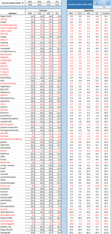
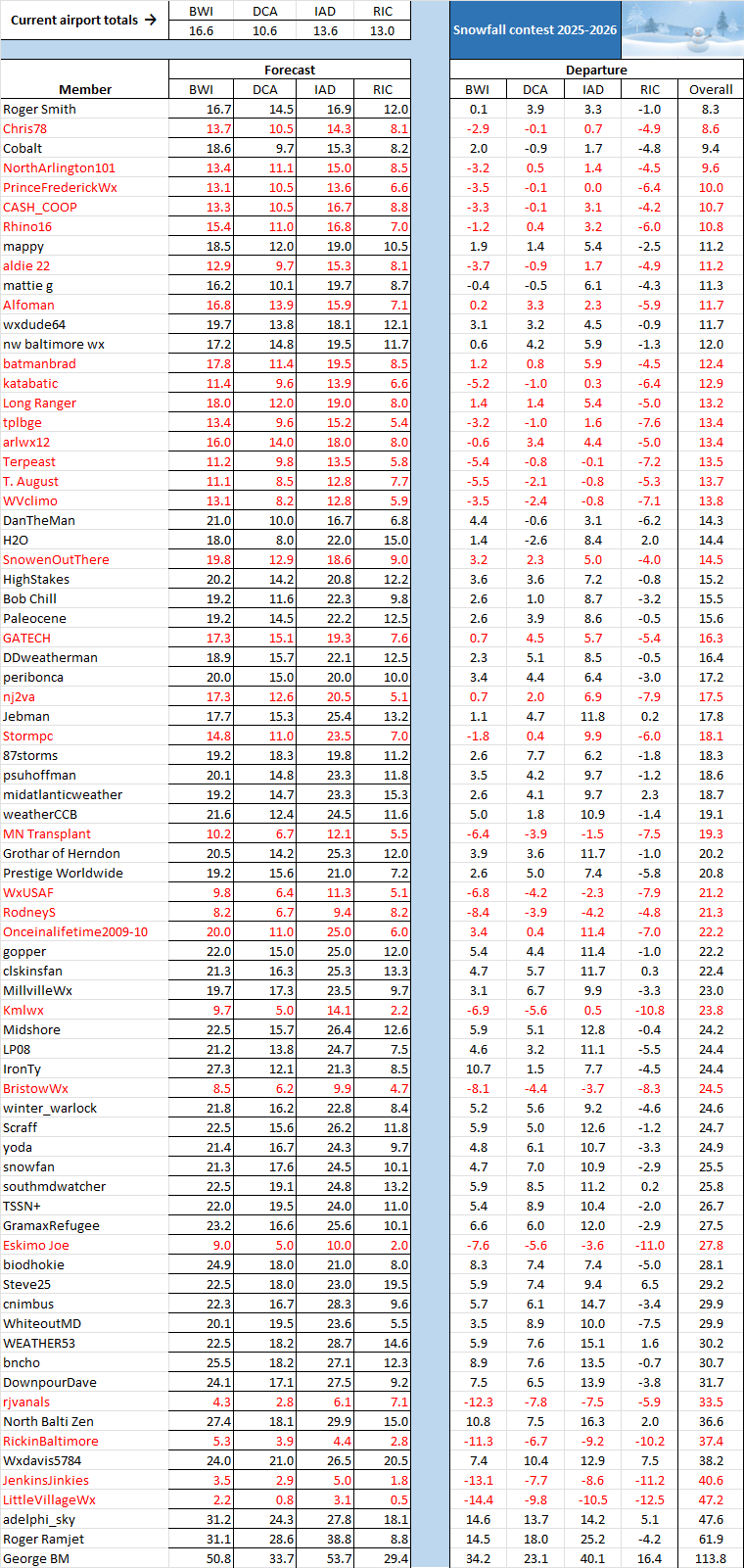
FYI, yesterday's DCA snow amount was upgraded from 0.1 to 0.2 inch. Also, yesterday's BWI snow amount is now listed as "missing" rather than a trace, which could mean that amount is being reevaluated. See revised table below:
-
Yes but if we go by @Eskimo Joe's superstition - these tend to fail. Our best days often are when SPC plays catch up - I think anecdotally this is sometimes true but it's more probably just mental in that when it's hyped up and it's only a middle of the road event, it sticks in our minds.
-
Can you share the 6z Euro?
-
DVN has issued a Watch for most, if not all, of its area it appears. Maybe not the very southern tier.
-
So long as the wind stays below skin tactility ... the sun will do a ton to offset the annoyance of cold air. It's not warm out? just to be clear. I realize there's some subjectivity to preference but 35 F will still cause hypothermia to anyone naked out there. That is my criteria - can a naked human being survive totally nude. If so, it's not cold. LOL. It probably still still pokes 43 or so. seriously tho, it's all about the sun and no wind at this time of year to reclaim some "nape value". If sitting on a park bench in that sun, and the wind is nary more than a zephyr's waft, creates this wonderful dichotomy to the senses. It's like you can tell it's cold, but at the same time, the protective invisible cocoon of warmth belies that reality - the sun is such liar, huh.
-
.thumb.jpg.6a4895b2a43f87359e4e7d04a6fa0d14.jpg)
Central PA Spring 2026 Discussion/Obs Thread
Yardstickgozinya replied to Voyager's topic in Upstate New York/Pennsylvania
One man's classic is another man's diarrhea. -
Central PA Spring 2026 Discussion/Obs Thread
Yardstickgozinya replied to Voyager's topic in Upstate New York/Pennsylvania
With such a large 30% area already highlighted 4 days out on a forecasted nagatively tilted system coming out of the Mississippi valley while we're already on a bit of a convective heater gets me all hot in the trousers. . That said, the severe outlooks being placed so far east and mediocre surface temps warrant some bust concerns. If this forecast were to verify the main thing I'll be watching on Monday is the proximity and time of convective initiation, low level lapse rates, and moisture return. If we can score some juicy overlapping, there and some of the other parameters hold true, it should be one hell of a day, not far from home. -
I might have problem with the ground soil, not sure but I like the tote system, you seem to have it mastered. I already have the totes from my move last summer so may be the way to go.
-
This is the time of year when those places and the Rockies can play big time catchup
-
I don’t know what people’s expectations are but this weather is pleasant for the calendar. Full sun and light winds the real feel is fine for the long morning walk with the dog.
-
If i could, I would probably do the same as to what your considering, That area sits SW so it has sun on it all day, I have a lot of clay, And that area where i have the garden holds a lot of water so it would be impossible for ground plants, But i can control growth and pest much easier making soil amendments every year
-
Your wet season is coming up.
.thumb.png.215ee7613b4b1f3fd3f9f8a5860fbae4.png)
-
Not when a trace. Just snow in the air over here. 1.41" of rain for the event.
-
Yes it does.
-
It’s been all locked up in the pack for months too…so deeper soil has been drying out and is ready to quickly absorb what we have back in. Once everything starts greening up it’s going to get sucked up quickly
-
Will be up there at SR March non skiing 23 to 25th looks cold and snowy .
-
We're starting a bigger garden this spring up here, we have a good spot that gets plenty of sun, not sure if I'll use totes like you nor not yet.
-
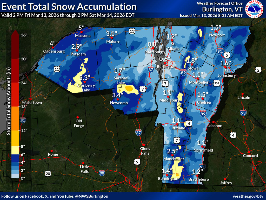
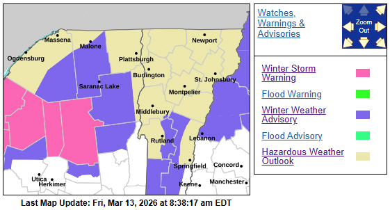
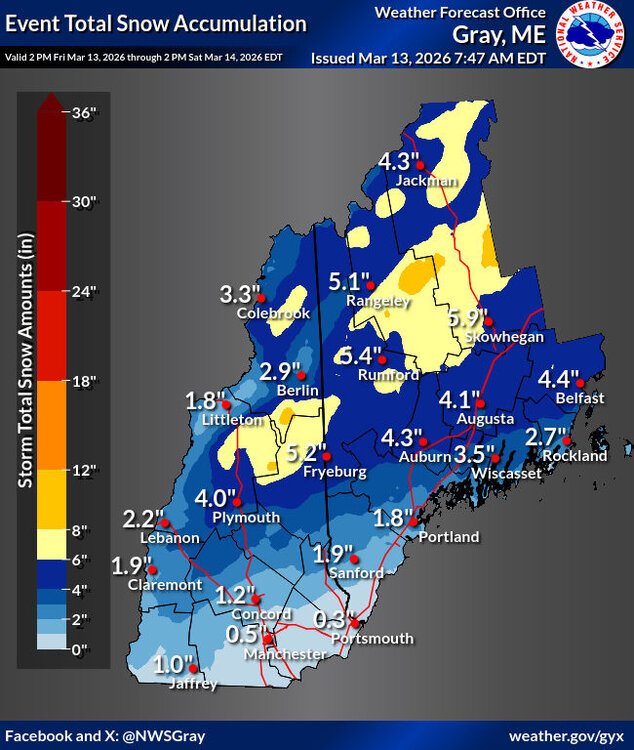
I’d seen in the BTV NWS forecast discussion that Winter Weather Advisories were going up in association with the next system moving into the area, but there wasn’t any specific mention of alerts here in Northern Vermont. Now that I look at the BTV NWS alerts map though, I see that the area is surrounded by Winter Weather Advisories and Winter Storm Warnings, and some of the projected snow accumulations are substantial, so there’s certainly a lot going on. The Event Total Snow Accumulation map shows some areas of 6-8” shading here in the Northern Greens, and some of the mountain point forecasts are coming in with 12”+ of snow through Sunday. The BTV NWS forecast discussion does highlight the QPF only topping out around 0.4” with shadowing in many areas due to the track, but they also point out the locally higher amounts possible along the western slopes, and the accumulations map certainly highlights that. Some models show >0.5” of liquid along the spine, and we’ll see how things evolve with the next update ahead of the system. With the spring cycling and refreeze that the snowpack has seen over the past few days, it’s going to take a decent amount of liquid equivalent for resurfacing of the slopes, but every bit of liquid that comes with this system will increase the angle of terrain that comes into play and enhance the potential for decent turns.

-
D4 30% must be pretty damn rare for this area, especially in mid march, right?
-
8”ish
-
That's where you tell them "So if you're 'pros,' who's paying you so I can sue them into oblivion for hiring your dumb a**?" Fortunately, while I've seen a few "questionable" driving decisions but nothing egregious like that around storms...so far. Actually had a chase partner for the first time in a while on Tuesday. It was pretty low-key around the Galesburg/Kewanee/Princeton cell, probably because most people were either on the Kankakee storm or frantically trying to get back to it (which no doubt resulted in more bad driving). That sounded like a highly stressful intercept for just about everyone involved, and it seems it was only photogenic for a short time before rain wrapping and/or darkness set in, so I'm not too broken up about missing that.
-
That'll happen everywhere in the continent except for this specific region right here
-
This sucks after earlier in the week but its early march still.
-
My father-in-law is with us this week, he turned 84 in Feburary. You'll make it.
-
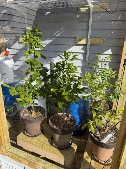
Mine are very happy, Going to be another 10 weeks or so before they get outdoors.


.png.46a76aa309c1cc16f50ce96b79f086bb.png)