All Activity
- Past hour
-

“Cory’s in NYC! Let’s HECS!” Feb. 22-24 Disco
ORH_wxman replied to TheSnowman's topic in New England
I think amounts could be similar with higher upside in the jackpot areas. The wind will be far bigger though and cause a lot more drifting. -
Same. I got in 6+ at .20 then a few hours later it more than doubled
-
Disagree. If over and under is 12.9. Go with the under to cash in. You know whoever measures is most likely on the take. Forecasts are for more than 12.9. He will measure less. Follow the $
-
Your moment may be at hand, Roger, because you are the closest entrant to the lead who still has all positive departures. However, you need to watch your back, with @mappyin position to pick up on you if BWI's total exceeds three inches.
-
Don’t forget to tag Randy in your snow pics so he doesn’t get FOMO.
-
Got in days ago for the over on 6 inches at 4/1 odds - feeling confident lol .
-
No need to chase, we’re all getting crushed.
-
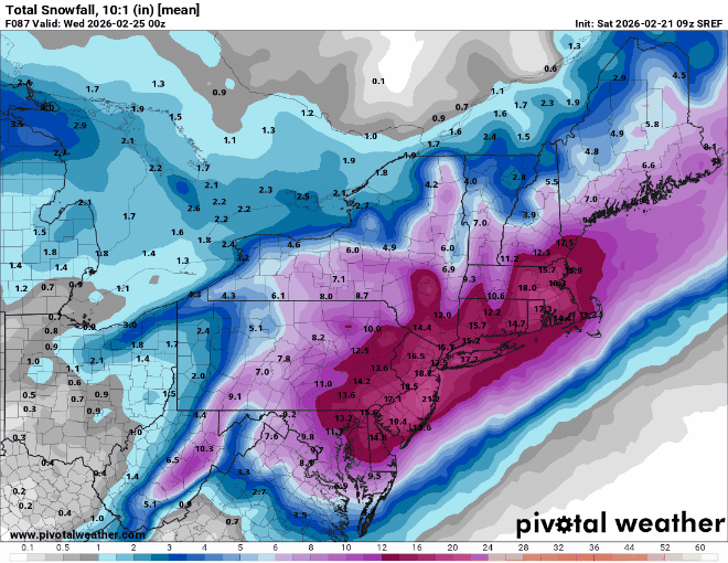
15z SREF did not disappoint. 9z to 15z trend
-

“Cory’s in NYC! Let’s HECS!” Feb. 22-24 Disco
Chrisrotary12 replied to TheSnowman's topic in New England
I mean if this verifies then I'd rather not honestly. -

Central PA Winter 25/26 Discussion and Obs
anotherman replied to MAG5035's topic in Upstate New York/Pennsylvania
Sent from my Mom just now…. -
Anyone want to bet no snow and show up with heaters? .
-
I don't know if any of you have watched the TV show Ax Men, but to quote swamp man Shelby, "Here we go!"
-
The way they measure in Central Park sometimes, not all the time, this could really be open to a lot of fraud accusations.
-

“Cory’s in NYC! Let’s HECS!” Feb. 22-24 Disco
CoastalWx replied to TheSnowman's topic in New England
Yeah I’m not a QPF queen, but I’d like to see euro a smidge higher. On the other hand maybe mid levels are better here with that look. -
They really classic big ones always throw a few surprises along the way. Let's see how far back to the Southwest the deform band can get. Will there be more movement west and south with the low? Can it bomb quicker? There's still time for adjustments.
-
Winter Storm Warning for 8-16in in the Valley.
-
Blizzard warnings to the Delaware River now.
-

February 22-23 Storm Thread/OBS
MickeyTim6533 replied to Mikeymac5306's topic in Philadelphia Region
does anyone think this will come even more west? -
 NYC 21.1” LGA 20.6” ISP 24.6” JFK 19.6” EWR 20.5”
 -
The blizzard warning probably covers that but maybe not
-


-
15-23 in the P&C. Wild event imminent. LFG
-
I'd chase this one if I wasn't sick. Can't believe the Goofus might actually get one right this season.
-
Also a blizzard warning for parts of DE/PA... URGENT - WINTER WEATHER MESSAGE National Weather Service Mount Holly NJ 154 PM EST Sat Feb 21 2026 DEZ002-NJZ017>019-021-220800- /O.UPG.KPHI.WS.W.0002.260222T1500Z-260223T2300Z/ /O.EXA.KPHI.BZ.W.0001.260222T1500Z-260223T2300Z/ Kent-Gloucester-Camden-Northwestern Burlington-Cumberland- Including the cities of Moorestown, Glassboro, Dover, Cherry Hill, Mount Holly, Millville, and Camden 154 PM EST Sat Feb 21 2026 ...BLIZZARD WARNING IN EFFECT FROM 10 AM SUNDAY TO 6 PM EST MONDAY... * WHAT...Blizzard conditions expected. Total snow accumulations between 14 and 20 inches. Winds gusting as high as 45 mph. * WHERE...In Delaware, Kent County. In New Jersey, Camden, Cumberland, Gloucester, and Northwestern Burlington Counties. * WHEN...From 10 AM Sunday to 6 PM EST Monday. * IMPACTS...Travel could be very difficult to impossible. Areas of blowing snow could significantly reduce visibility. The hazardous conditions could impact the Monday morning and evening commutes. Gusty winds could bring down tree branches.
-

Central PA Winter 25/26 Discussion and Obs
Blizzard of 93 replied to MAG5035's topic in Upstate New York/Pennsylvania
I like the large amount of member clusters near & west of the Op. If the 8 far east members are eliminated, the mean would be even more tucked.


.thumb.png.991e09c19c25af7391ed569a205a5136.png)


