All Activity
- Past hour
-

Pittsburgh/Western PA WINTER ‘25/‘26
MikeB_01 replied to Burghblizz's topic in Upstate New York/Pennsylvania
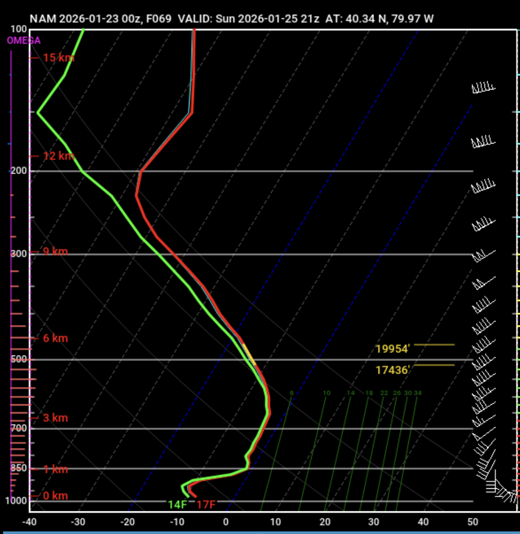
here is the sounding for the NAM when the sleet makes it closest to SAGC. Can you imagine getting sleet at while it is 17° at the surface?! would be wild
-
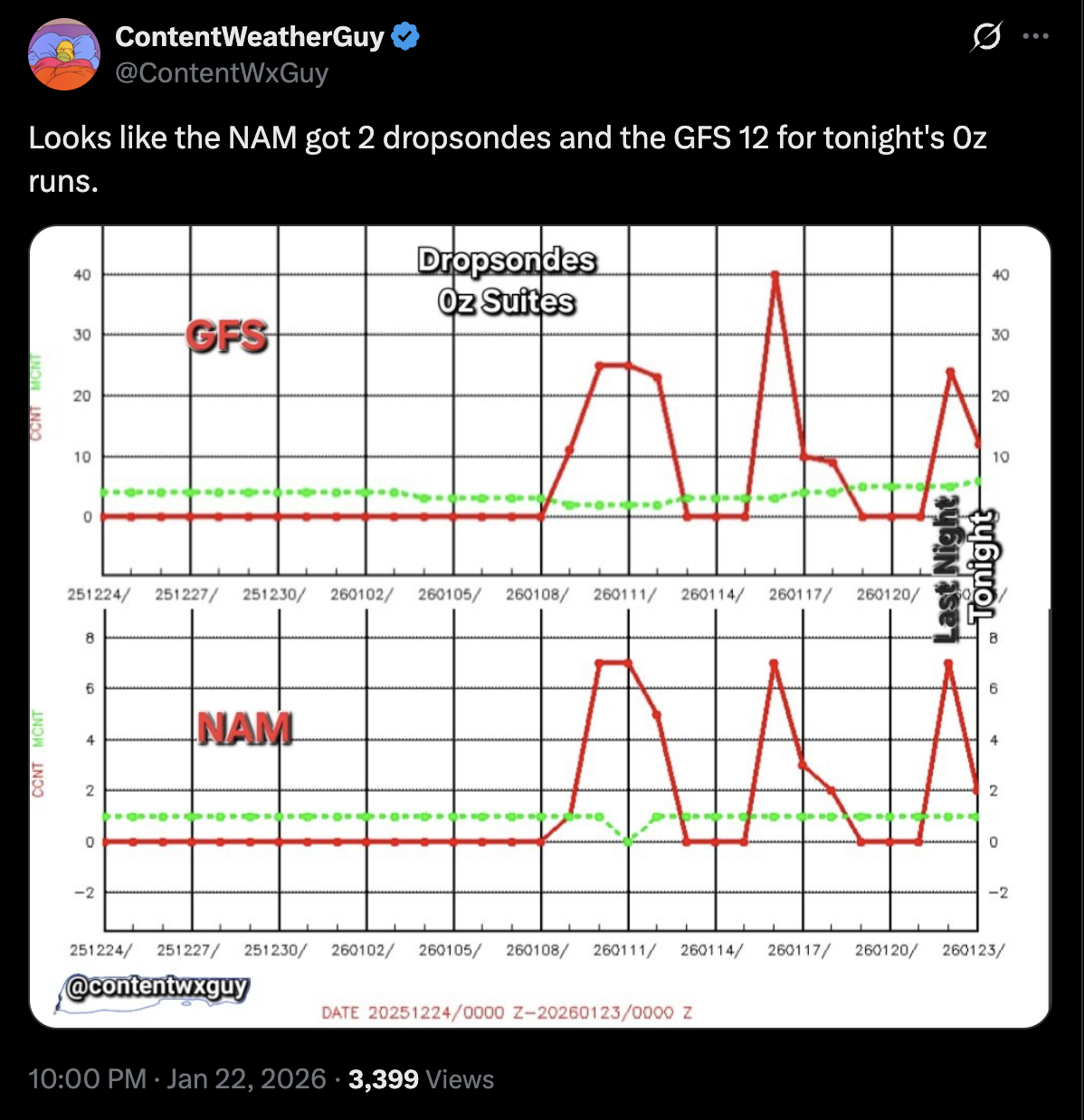
It’s clearly using some sort of ratio formula in addition to the QPF since that’s way more than 10 to 1 model consensus would imply.
-

Possible Record Breaking Cold + Snow Sunday 1/25 - Tuesday 1/27
SACRUS replied to TriPol's topic in New York City Metro
1/23 GFS AI AIGFS total QPF storm -
GFS still trying to start with snow for northern part of NC
-

“Cory’s in LA! Let’s MECS!” Jan. 24-26 Disco
40/70 Benchmark replied to TheSnowman's topic in New England
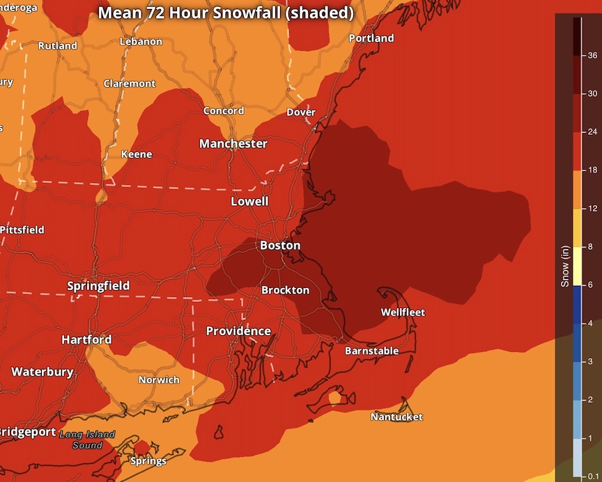
Yes. This is what I tried to convey in my First map...I didn't explicitly display 20", but denoted that amounts in excess of 18" are possible in select areas. -
-

Central PA Winter 25/26 Discussion and Obs
pasnownut replied to MAG5035's topic in Upstate New York/Pennsylvania
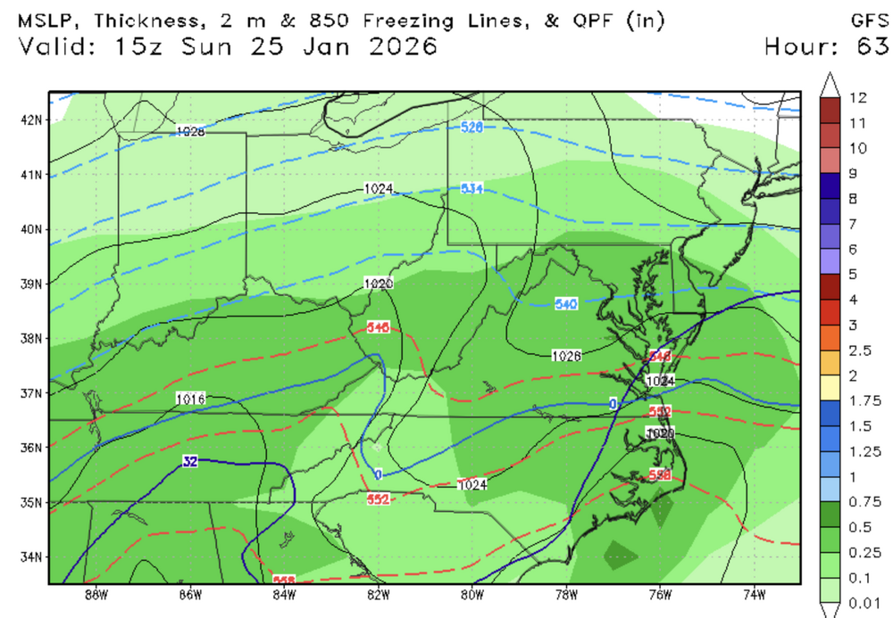
thru 54 very minor changes overall -
Detroit rarely ever gets lake effect snow. Study up, man.
-
GFS has snow again
.thumb.png.6096c7bca56c8d98e8c23e38d0162677.png)
-

January 24-26: Miracle or Mirage JV/Banter Thread!
nj2va replied to SnowenOutThere's topic in Mid Atlantic
Dude, you might want to just stop looking at models tonight lol. We’re going to see snow - but we’re all (or most of us) mixing. Hopefully we can keep it at bay for as long as possible. -
so far, it's not budging

-

Pittsburgh/Western PA WINTER ‘25/‘26
Burghblizz replied to Burghblizz's topic in Upstate New York/Pennsylvania
I think it’s a potential replacement for HRRR/RAP and those tend to compound thermal errors outside of 18 hours. -

January 24-26: Miracle or Mirage JV/Banter Thread!
Steve25 replied to SnowenOutThere's topic in Mid Atlantic
Suddenly would it be a weenie thing to say I’m expecting 6 inches of snow and then a sleet bomb in Baltimore? Or is that fairly realistic and people are just angry because they wanted it to be 12-18 inches of snow? -
I literally could not remotely care less about Chicago LES - if you wanna discuss this further, do so in banter.
-
Curious what goes into this blend... it keeps revving up. Here's the 1z Jan 23 NBM output:
-
Correct me if I'm wrong but it looks like it splits sleet/snow line in half over knox co. at hour 48.
-
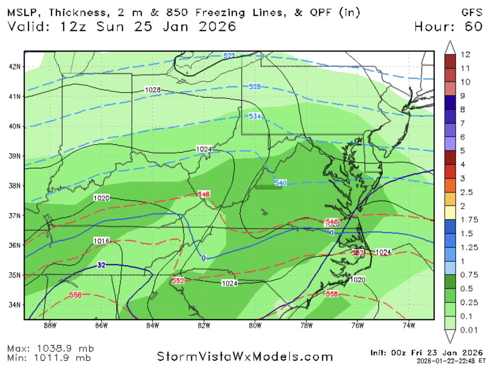
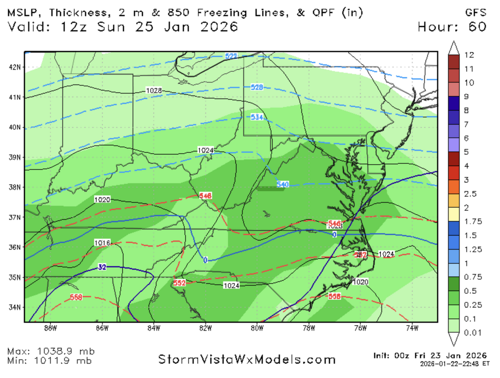
00Z GFS looks similar to previous.
-

January 25/26 Jimbo Back Surgery Storm
palmettoweather replied to Jimbo!'s topic in Southeastern States
Agreed. Watching the early returns from 0z suite, there isn’t the support for the massive ice totals being forecasted, from both QPF and temperature perspective. It’s early, but out to 45, GFS seems to be moving towards 0z NAM. -
Central PA Winter 25/26 Discussion and Obs
pasnownut replied to MAG5035's topic in Upstate New York/Pennsylvania
GFS thru 42, thermals a touch warmer but not a big deal yet -
I mean the Great Lakes are right there...
-

January 24-26: Miracle or Mirage JV/Banter Thread!
LordBaltimore replied to SnowenOutThere's topic in Mid Atlantic
The GFS isn't really even a shit model. The model itself is the least important part of prediction. The problem is that years ago everyone decided to take some French guys hair-brained idea and adopt what's unfortunately known as "JEDI" which has become an absolute black hole for man-hours and resources that would otherwise be spent tuning and incrementally improving -
Yes. I think some of these maps are on the aggressive side at the moment. Not that 20”+ is implausible here, but I think we’d need some things to go right for that to happen based on current guidance.
-

January 24-26: Miracle or Mirage JV/Banter Thread!
Nomz replied to SnowenOutThere's topic in Mid Atlantic
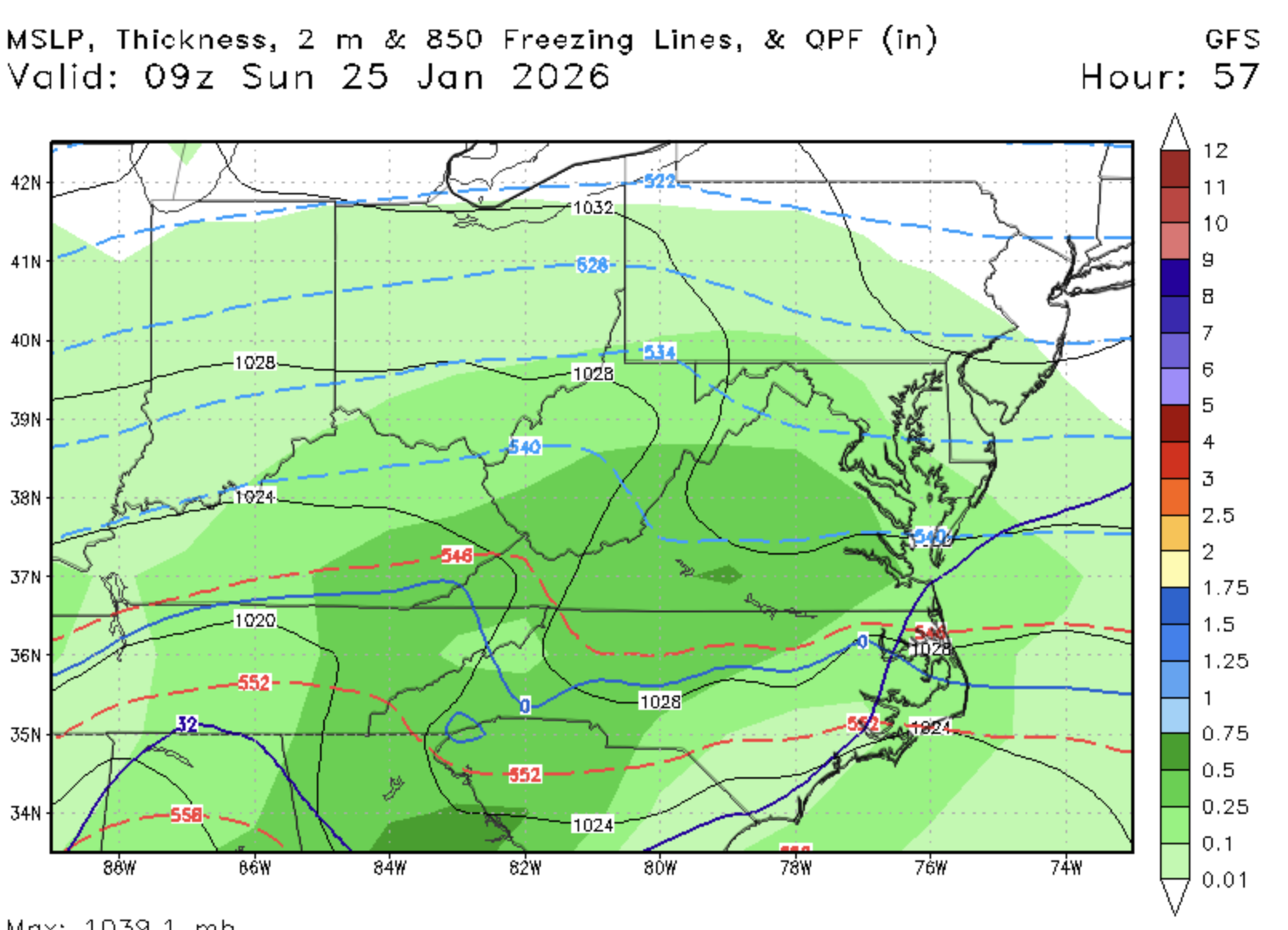
Some weenie cope for us if the GFS somehow holds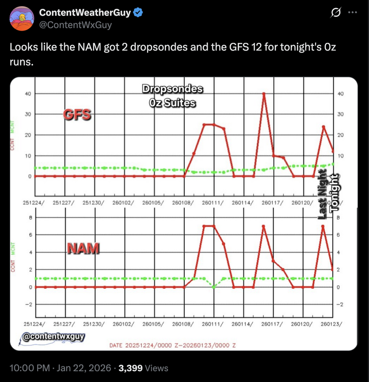
-

January 24-26: Miracle or Mirage JV/Banter Thread!
clskinsfan replied to SnowenOutThere's topic in Mid Atlantic
Ya think????? -

MO/KS/AR/OK 2025-2026 Winter Discussion
rockchalk83 replied to stormdragonwx's topic in Central/Western States
That's the million dollar question. I wonder if @andyhbor @JoMowould be able to shed some light on this?


.png.6ea21684256532fa9a8923e35fcf80c6.png)