All Activity
- Past hour
-

Septorcher 2026 Discussion - Endless Summer
SJonesWX replied to Damage In Tolland's topic in New England
relentless torch? LOLOLOLOLOLOLOL -

Fall 2026 Medium/Long Range Pattern Thread
Carvers Gap replied to John1122's topic in Tennessee Valley
Guidance today is moving to the quicker transition and breakdown of the heat ridge. Ensembles and deterministic models generally have a pretty big change coming. Even the Apple app has me in the 70s next week for highs. The real feels will be almost 25 degrees cooler than this weeks. -

2026-2027 Record-breaking El Nino
GaWx replied to Stormchaserchuck1's topic in Weather Forecasting and Discussion
The SOI has been negative for 37 days in a row. -

2026 Atlantic Hurricane Season
WxWatcher007 replied to Stormchaserchuck1's topic in Tropical Headquarters
Well this one is dead and buried -

Septorcher 2026 Discussion - Endless Summer
mreaves replied to Damage In Tolland's topic in New England
It has been dry here. The irrigation ponds at the golf course have dropped considerably over the last few weeks. -

Septorcher 2026 Discussion - Endless Summer
weatherwiz replied to Damage In Tolland's topic in New England
Yeah, I'm just not sure how much I buy it. We've seen plenty of times, especially early in the season where guidance gets way too coastal happy. I'll say though, I am not looking forward to Fall or Winter weather forecasting. I don't think this has gotten the proper attention this deserves but the reduction in balloon launches I think is going to have severe negative impacts on models and forecasting. In fact, we've even seen it this summer. There have been multiple instances where local NWS offices in the central Plains/Midwest and I think even from SPC where they noted the reduction in launches having a significant impact on even short-term severe forecasting. I know we have better equipment and technology from satellites but balloon launches are still a critical part in the modeling process. -
We are on the schedule next week for our long-awaited patio install. It's gonna pour folks!
-

Septorcher 2026 Discussion - Endless Summer
40/70 Benchmark replied to Damage In Tolland's topic in New England
Same people bitching about the two weeks of rain would be panicking about how we aren't seeing coastals start to show in the lead up to winter. -
Septorcher 2026 Discussion - Endless Summer
WxWatcher007 replied to Damage In Tolland's topic in New England
A good signal for coastal systems the next two weeks. -
If the northern interior and elevations can squeak out all winter months < 5 F above normal (might be tough to pull off in December) they should do just fine with all the ample moisture. Coast I think is more hit or miss. We'd likely need a period with good blocking to get close to seasonal.
-

Occasional Thoughts on Climate Change
Typhoon Tip replied to donsutherland1's topic in Climate Change
More concisely the point I was after ... AI is not a spontaneous emergence. It's not just you. There's a palpable vibe in the ongoing meme of it all, an ominous implication, as though it is an unstoppable spontaneous emergence. A lot of that is the "AI Executa"'s doing. They've certainly been helping to create a uncertain, if not unnerving scenario end game but ... has it never stuck anyone as odd that no one has said the following yet? stop creating it Again, AI is not the threat; the humans being creating it are the threat. AI won't emerge on it's own. If there is that much daunting uncertainty as to the end game, then the solution in prevention is only unclear to a 5-year old. Anyway, so I am not really disagreeing with you that it could be an agency of harm? Of course that's true. That could come about both wittingly, or unwittingly. For fun: The "witting" rendition is that we are all being manipulated in a really diabolical way... The apparatus of progenitors of the "AI brain" (think giant cube in "Hitchhiker's Guide To The Galaxy" ha!) are consummately warning of this that and the other thing, as though when we've arrived into any such state of affairs ( their actual goal), they can blame it on the 'we warned you' divisiveness. As though the consequence was built in, and not their fault - -as though it is our for allowing them? That would never work, of course. As dumbed-down and feckless, willing to be led around and guided as human's of this generational leg of the Industrial bubble have become, there's still enough intelligentsia in there to place blame appropriately should Skynet launch missiles. However, here's the diabolical thing: they know that. They're not actually trying escape culpability - they really don't care. No morality there. No ...they're trying to diverge our attention along the way. All there warnings come off as much like propagandizing it's advent in history, but one thing I'm noticing also is that it's keeping us stoned by our collect fascination. Maybe helped along by civility's apparent epidemic psycho-tropic 'blue-light' dystopian addiction. As stimulation junkies, we just want the high from their story. ...until we are in a realm when it has become too late. What they've really created was the sociopath's utopia (ooh, that's a cool title for a book!) Heh, that's a fun James Bond plot perhaps. Then there's the unwitting rendition - which despite the fantastic above is actually a harder sell for me. Just because of the nature of what consciousness appears to be. That's why I cited Roger Penrose, and stopped just short of shamelessly punching my own published work on the matter ( nyuk nyuk). His et al was a Physical peer review. I did not know it existed prior or during when I set out to create my story. I stumbled upon the idea listening to NPR at a stop sign, circa 2004. They background was an interview with a world renowned Neurophysiologist - no means to recall the name or salutation from this range. The conjectural concepts for my novel eerily describe precisely the Penrose: magnetically conductive microtubules are instrumental in the emergence of consciousness. There may be other ways in the Universe to create consciousness - duh. Perhaps "create" isn't the right word. Perhaps "emerge" really is the best and we should stick with that, because all science and perspectives (history) agrees that its origin is an emergence. We can confidently suggest at a minimum that all brains on earth engage in a chemical-physiologically guided electrodynamic dance. Sparks on invented tools the turn electroencephalography (EEG) into visualization, for example, evince what ancient scholars already knew...etc. At a minimum that is so. Consciousness is kind of separate from that. Penrose et al outright implicate Physically that it is not where consciousness originates, rather, quantum feedback is implied. As I told implicitly in my story, it is a synergistic byproduct of the same processing. So all brains are a chemical-physiologically guided electrodynamic process. The amount and coherence of synergistic emergence from that is variable. Consciousness is like gravity, though. Try and try as we must ... the brain trust of Humanity will never be able quantize gravity. The ambit will stubbornly continue to spent trillions on colliders and University legislation and never will. We can only say that the moon has less gravity than the sun, but both have gravity. A mouse is less awareness of what is going on around in both discrete and abstraction than does the cat. Penrose et al would like to quantize consciousness. We cannot quantize consciousness. Consciousness, I strongly personally believe, is a field ...just like gravity. Just like magnetism. There are ultimately - though needing some sort of exotic math and matching breakthroughs of philosophy thereof - fields are that no quantized but are there because of other other actions. Though all of that... what we can infer with high confidence is, AI is not that. Haha. So again ...if there's another way to achieve higher order consciousness in the cosmos than so be it. Fine. We have to be open to that possibility. But where AI/research is, its not creating a bubble that is inflated by emergence. As far as the 8 billion elimination argument... It's easier to eliminate 8 million than it is to eliminate 8 billion. A planet colliding with Earth would do the trick on the latter, but since that would be exceptionally rare to the point of not happening in any practical discussion ... it follows that whatever catastrophe less than such extreme ... leaves at least a vestige. -
Yeah it doesn’t look like a disaster. I’m skeptical of these snow anomaly maps to begin with. I just thought it was funny SLK cleans up again. We want as many dice rolls as we can get. Keep it active and we can do ok.
-
I think if you live at least at 40 N or above you should be happy with the wet signal. It takes a seriously rotter winter to get tons of precip with little snow at that latitude (not saying it can't happen). I'd rather gamble with wet than get stuck with cold dry. I recall 2024-2025 was bitter cold on the east coast but absolutely bone dry because of the niña. Those winters suck.
-
How about pee pee?
-
 cheapest viagra: Belvion - sildenafil online
 -
Looks a lot like it save for the deep se/FL.
-
We have a shot at 3 months in a row where part of the region goes 10”+. Monthly Data for September 2026 for Upton NY NWS CWA Click column heading to sort ascending, click again to sort descending. CT NORTHFORD 0.8 SW CoCoRaHS 8.22 CT FAIRFIELD 1.5 NE CoCoRaHS 7.97 CT DARIEN 2.4 NW CoCoRaHS 7.64 CT NORWALK 1.4 ENE CoCoRaHS 7.36 CT TRUMBULL 2.6 SSE CoCoRaHS 7.14 CT STAMFORD 1.0 S CoCoRaHS 6.69 CT JEWETT CITY 3.0 ESE CoCoRaHS 6.68 NJ FAIR LAWN 1.2 SE CoCoRaHS 6.63 CT NORWALK 2.9 NNW CoCoRaHS 6.55 Monthly Data for August 2026 for Upton NY NWS CWA Click column heading to sort ascending, click again to sort descending. NJ CLARK TWP 1.3 ENE CoCoRaHS 12.48 NJ LINDEN 2.2 NW CoCoRaHS 12.19 NJ HARRISON COOP 11.78 NJ CRANFORD TWP 1.1 ESE CoCoRaHS 10.99 NY FRANKLIN SQUARE 1.1 N CoCoRaHS 10.92 NJ CLARK TWP 0.7 SSW CoCoRaHS 10.88 NJ KEARNY 1.7 NNW CoCoRaHS 10.88 NJ NEWARK LIBERTY INTL AP WBAN 10.19 Monthly Data for July 2026 for Upton NY NWS CWA Click column heading to sort ascending, click again to sort descending. NY BEACON 4.2 ESE CoCoRaHS 17.14 NY PEEKSKILL 2.8 NNE CoCoRaHS 16.45 CT BETHEL 0.5 E CoCoRaHS 15.83 CT DANBURY COOP 15.12 NY NELSONVILLE 0.3 S CoCoRaHS 14.54 CT NEWTOWN 5.3 S CoCoRaHS 14.51 CT BETHEL 3.5 NNE CoCoRaHS 14.07 CT OAKDALE 2.6 WNW CoCoRaHS 13.97 NY SHRUB OAK COOP 13.93 NY GARRISON 1.5 NE CoCoRaHS 13.76 CT NEWTOWN 4.6 SE CoCoRaHS 13.64 CT SALEM 3.6 SE CoCoRaHS 13.60 CT STRATFORD 0.2 ESE CoCoRaHS 13.43 CT SHELTON 1.3 W CoCoRaHS 13.23 CT SHELTON 1.3 W CoCoRaHS 13.12 CT NORTHFORD 0.8 SW CoCoRaHS 13.11 CT BETHEL 4.5 SSE CoCoRaHS 13.09 CT FAIRFIELD 1.5 NE CoCoRaHS 13.08 CT CHESTER CENTER 2.7 WNW CoCoRaHS 12.93 NY YORKTOWN HEIGHTS 2.7 NNW CoCoRaHS 12.43 CT TRUMBULL 2.6 SSE CoCoRaHS 12.43 CT BROOKFIELD 3.3 SSE CoCoRaHS 12.42 CT IGOR I SIKORSKY MEMORIAL AIRPORT WBAN 12.33 NY CARMEL 4N COOP 11.95 CT RIDGEFIELD 2.4 NNE CoCoRaHS 11.84 NY SEAFORD 0.4 SE CoCoRaHS 11.82 NY LAKE CARMEL 0.7 NE CoCoRaHS 11.75 NJ HAWTHORNE 1.0 SSE CoCoRaHS 11.71 CT SOUTHBURY 2.3 W CoCoRaHS 11.53 NY PATTERSON 1.3 E CoCoRaHS 11.28 CT GUILFORD COOP 11.19 NY NEW WINDSOR 3.3 W CoCoRaHS 11.18 NJ CEDAR GROVE TWP 0.4 W CoCoRaHS 11.17 CT DURHAM 1.2 W CoCoRaHS 11.14 CT WALLINGFORD CENTER 1.9 WNW CoCoRaHS 11.13 CT NEW CANAAN 1.9 ENE CoCoRaHS 11.06 CT LEDYARD 0.5 NE CoCoRaHS 11.04 CT WALLINGFORD CENTER 3.3 NNW CoCoRaHS 11.03 CT MIDDLEFIELD 1.4 W CoCoRaHS 10.97 CT MIDDLEFIELD 0.6 SE CoCoRaHS 10.96 CT RIDGEFIELD 3.6 N CoCoRaHS 10.92 NY CENTEREACH 1.3 NE CoCoRaHS 10.88 CT NORWALK 2.9 NNW CoCoRaHS 10.83 CT ANSONIA 1 NW COOP 10.78 NY STONY POINT 0.7 NW CoCoRaHS 10.73 CT STRATFORD 0.9 W CoCoRaHS 10.69 CT CROMWELL 0.4 WNW CoCoRaHS 10.62 CT WALLINGFORD CENTER 1.1 N CoCoRaHS 10.55 NJ RIVER EDGE 0.4 NNE CoCoRaHS 10.32 CT PROSPECT 1.9 ENE CoCoRaHS 10.31 NY PORT JERVIS COOP 10.30 CT LEDYARD 2.8 NNE CoCoRaHS 10.25 NJ MONTCLAIR 0.7 N CoCoRaHS 10.22 NJ FAIR LAWN 0.9 E CoCoRaHS 10.22 NY MOUNT SINAI COOP 10.21 CT NORWICH 5.4 SE CoCoRaHS 10.17 NJ WAYNE TWP 2.3 ESE CoCoRaHS 10.13 CT SHERMAN 1.2 E CoCoRaHS 10.13 CT HIGGANUM 0.7 N CoCoRaHS 10.13 CT HIGGANUM 0.8 NE CoCoRaHS 10.05 CT NORWICH 5.2 SE CoCoRaHS 10.04 CT WALLINGFORD 3.1 N CoCoRaHS 10.03
-
(002).thumb.png.6e3d9d46bca5fe41aab7a74871dd8af8.png)
Central PA Summer 2026 Discussion/Obs Thread
ChescoWx replied to Voyager's topic in Upstate New York/Pennsylvania
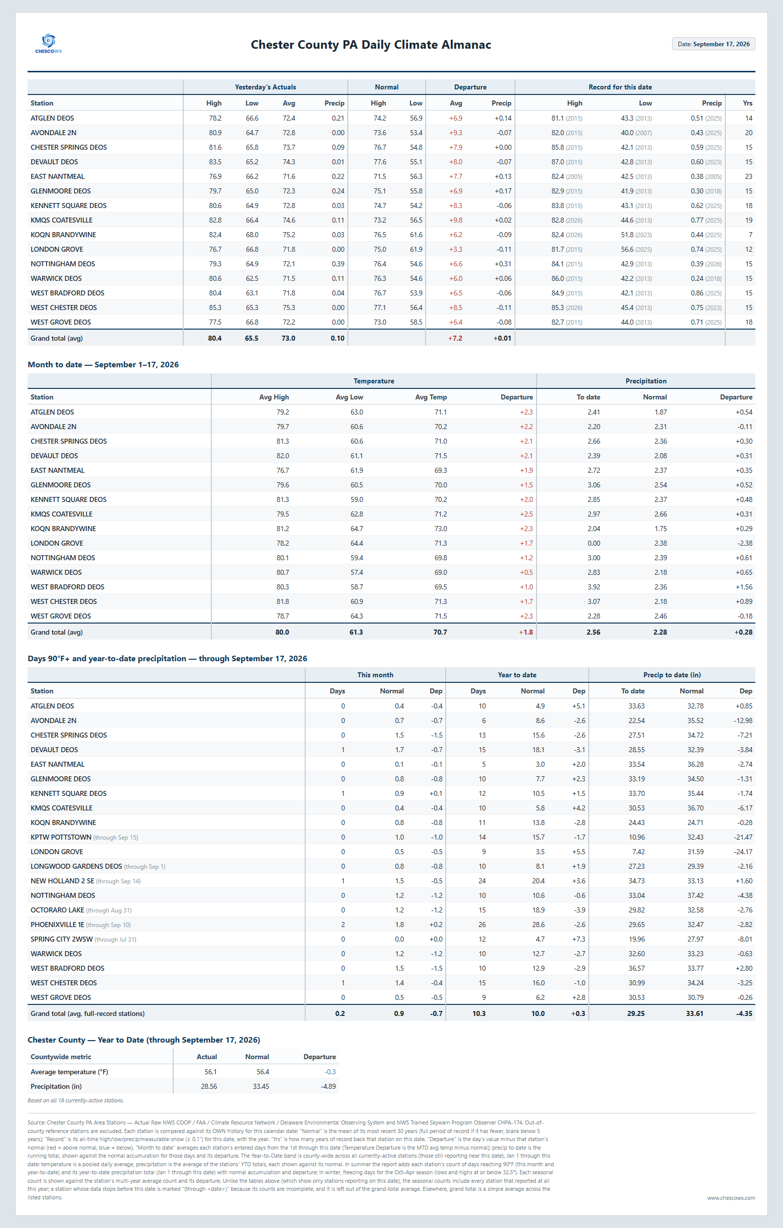
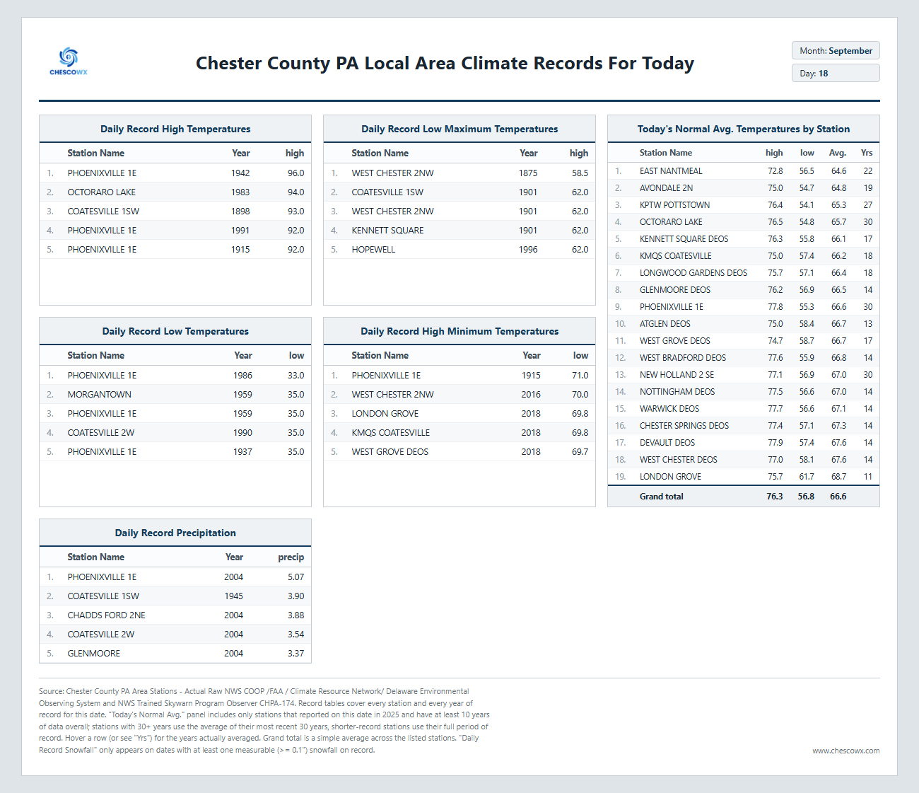
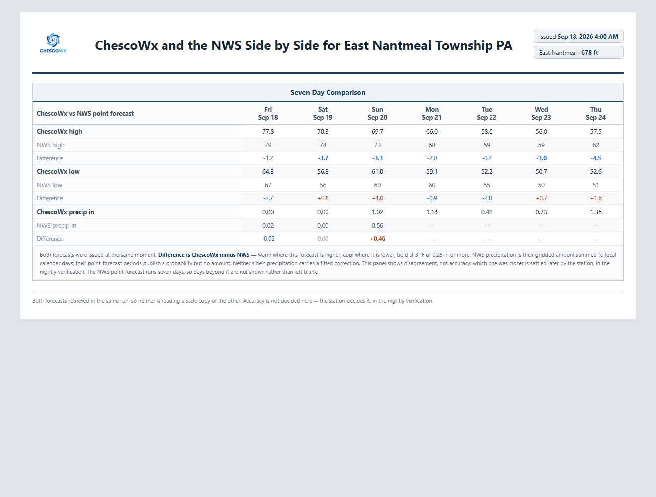
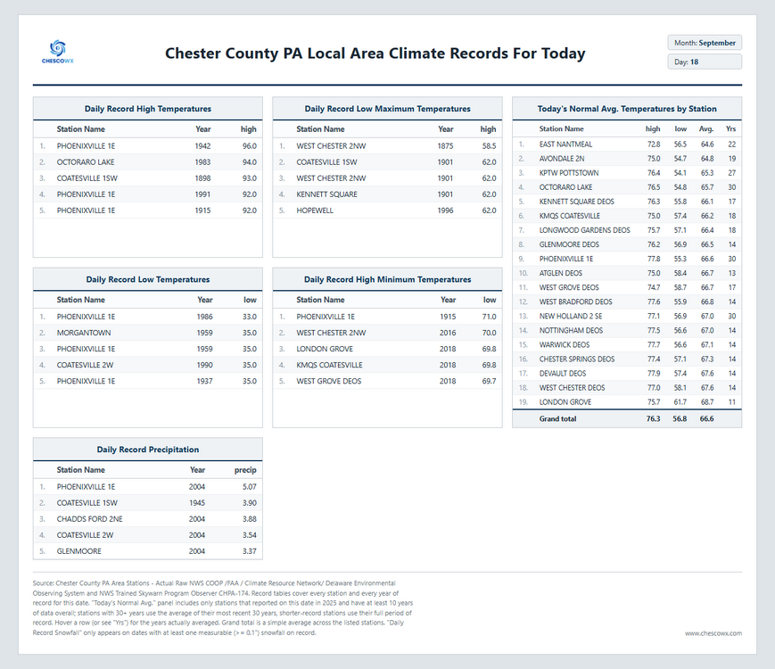
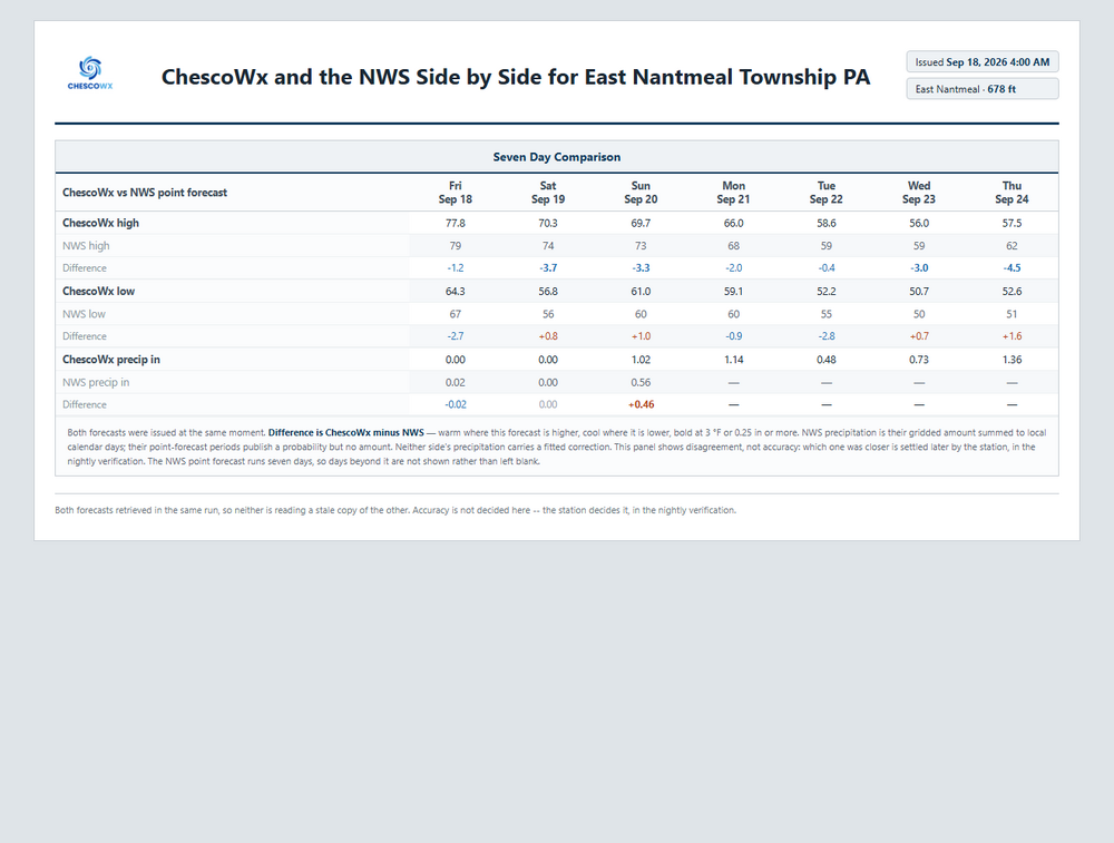
Today will be the last day for over a week with above normal temperatures in the upper 70's to near 80 degrees. We fall off to the upper 60's to low 70's tomorrow and with near record setting low maximum temperatures possible both Tuesday and Wednesday. High temperatures both of those days will struggle into the mid to upper 50's. Those temperatures are typical for November 10th! In addition to the unseasonable chill this week it will also be very wet. Rain chances increase by Sunday, and chances remain each and every day of the new work week. The in-house ChescoWx model predicts over 4 inches of rain this week!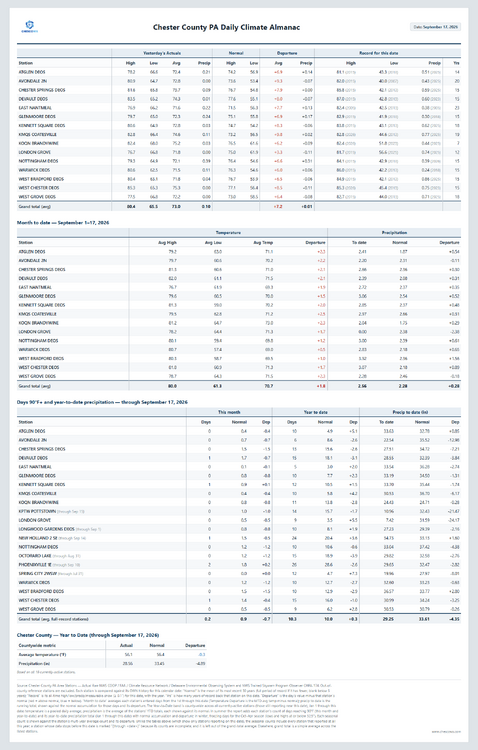
-
E PA/NJ/DE Autumn 2026 Obs/Discussion
ChescoWx replied to PhiEaglesfan712's topic in Philadelphia Region
Today will be the last day for over a week with above normal temperatures in the upper 70's to near 80 degrees. We fall off to the upper 60's to low 70's tomorrow and with near record setting low maximum temperatures possible both Tuesday and Wednesday. High temperatures both of those days will struggle into the mid to upper 50's. Those temperatures are typical for November 10th! In addition to the unseasonable chill this week it will also be very wet. Rain chances increase by Sunday, and chances remain each and every day of the new work week. The in-house ChescoWx model predicts over 4 inches of rain this week!
-

E PA/NJ/DE Autumn 2026 Obs/Discussion
The Iceman replied to PhiEaglesfan712's topic in Philadelphia Region
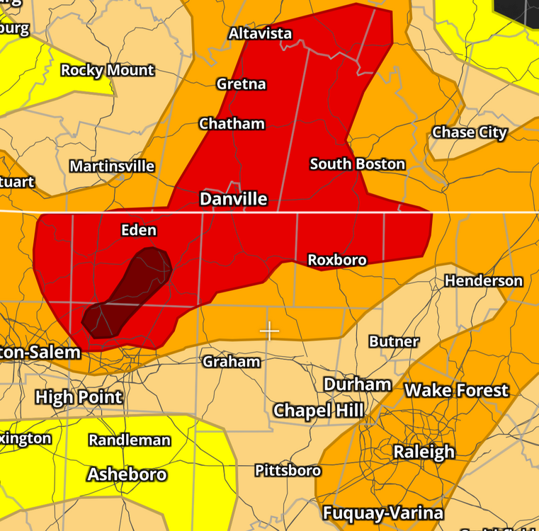
Next week looking wet... I don't have my official total nearby for the month but I believe we are already at 5" or so. Could we get back to back months of double digit(10"+) rainfall? The drought has been beaten back big time this summer, crazy this was the drought map just 3 months ago! to now: -
Drought outlook update
-
Cialis over the counter: menon36 - Tadalafil price
-
Classic ridge on top onshore flow and trough cutoffs underneath into the northeast 9/21 - 9/26
-
Two rain events last weekend, but only 0.8" total. Also our monthly total. Drought conditions also declined- from D1 to D2.
-
ecords: Highs: EWR: 90 (1992) NYC: 91 (1891) LGA: 89 (1965) JFK: 90 (1965) Lows: EWR: 42 (1937) NYC: 44 (1990) LGA: 49 (1990) JFK: 46 (1961) Historical: 1752: The hurricane of 1752 was one of the most devastating in the history of Charleston, SC. Although the number of fatalities could not be determined, a contemporary Boston press report, based on a ship officer's account, estimated that 95 people drowned. The destruction of trees was severe. One plantation owner's loss was assessed at $50,000. (Ref. AccWeather Weather History) 1816: A tropical storm affected Virginia before moving northeast into New York. Heavy rains caused the James river in Richmond to rise only an inch or two lower than the High Fresh of 1814. Flood waters invaded the first floors of area homes. One bridge was submerged, cutting off travel (Chapman). (Ref. for Tropical Storm of 1816) 1886: A tornado moved along the Des Plaines River in northeast Illinois, hitting the city of Joliet. The tornado destroyed 20 homes, 10 barns, two factories, and a grain elevator; a bridge was moved intact for two blocks. 20 people were injured, but the loud roar of the approaching tornado allowed residents time to take shelter, so no one was killed. (Ref. Wilson Wx. History) 1926 - The great ""Miami Hurricane"" produced winds reaching 138 mph which drove ocean waters into the Biscayne Bay drowning 135 persons. The eye of the hurricane passed over Miami, at which time the barometric pressure reached 27.61 inches. Tides up to twelve feet high accompanied the hurricane, which claimed a total of 372 lives. (David Ludlum) (The Weather Channel) 1933: The September 17th and 18th storm gave 13.27 inches of rain at Provincetown, MA causing severe flooding! (Ref. Notable New England Hurricanes) 1936: A passing hurricane did heavy damage in Salisbury Maryland and gave 4.61 inches of rain in Washington, DC and Baltimore received only a trace of rain. 1936 Hurricane Track - Weather Underground 1941: A remarkable aurora borealis or "northern lights" was observed as far south as north Florida on this night and the 19th. (Ref. Wilson Wx. History) 1971: A brush fire at Lake Alexander, MN in Morrison County started a 10-foot wide, 50-foot high "fire whirl." It moved out over the lake, overturned a 1,800 pound pontoon boat, and then dissipated as it moved back to shore. (Ref. AccWeather Weather History) 1950: Hail covered the ground to a depth of 2 inches at Phoenix, AZ. Damage was extensive at the airport, where 22 planes were destroyed. (Ref. Wilson Wx. History) 1978: Parts of the northern Rockies received some early season snow. 21 inches of snow fell at Red Lodge, MT reported 21 inches. Lesser amounts fell at lower elevations. Joliet, MT received 1.5 inches and Billings, MT received a trace. (Ref. Wilson Wx. History) 1987 - Early morning thunderstorms in northern Texas produced wind gusts to 65 mph at Sulphur Springs, and 2.50 inches of rain in one hour at Commerce, which caused widespread street flooding. Bonham TX received 4.50 inches of rain which also resulted in widespread street flooding as Pig Branch overflowed its banks. (Storm Data) (The National Weather Summary) 1988 - A strong cold front produced severe thunderstorms in the north central U.S. High winds behind the cold front gusted to 92 mph at Fort Collins CO, and up to a foot of snow blanketed the mountains of Montana, with seven inches reported at Great Falls. High winds in Colorado caused three million dollars damage. (Storm Data) (The National Weather Summary) 1989 - Hurricane Hugo hit Puerto Rico, producing wind gusts to 92 mph at San Juan, and wind gusts to 120 mph at Roosevelt Roads. Hugo produced a storm surge of four to six feet, and northeastern sections of the island were deluged with more than ten inches of rain. Hugo claimed the lives of a dozen persons in Puerto Rico, and caused a bilion dollars damage, including 100 million dollars damage to crops. Thunderstorms representing what remained of Hurricane Octave continued to bring heavy rain to the valleys of northern California. Heavier 24 hour rainfall totals included 3.15 inches at Redding, and 2.66 inches at Red Bluff. (The National Weather Summary) (Storm Data) 1991: 2.4 inches of snow fell at Duluth, MN to set not only a new record daily snowfall but also a new record total for September. The previous record snowfall for September was 1.5 inches set back in 1908. (Ref. AccWeather Weather History) 2003: Hurricane Isabel made landfall along the Outer Banks of North Carolina with maximum sustained winds near 100 mph and a minimum central pressure of 956 millibars or 28.23 inches of mercury. The greatest impacts were felt in North Carolina and Virginia. Hurricane Isabel gave Annandale - Barcroft Hills Weather Center a 41 mph wind gust today at 1603 which was the highest wind ever recorded for September at this station.