All Activity
- Past hour
-
64 right now Lets switch airmasses
-

2026-2027 El Nino
40/70 Benchmark replied to Stormchaserchuck1's topic in Weather Forecasting and Discussion
We have also had three consecutive El Ninos that have been shitty for snowfall in the NE....I would have to look, but I'm not sure we have ever had four consecutive. Some of this stuff is a bit anecdotal, but I think it does have value in hedging towards more likely outcomes. -
Yeah the old timers always say 42 and drizzle really speeds up the greening vs 70 and sunny.
-
Had a brief period of marbles around 6am here. Picked up 0.11" overnight.
-
2026-2027 El Nino
40/70 Benchmark replied to Stormchaserchuck1's topic in Weather Forecasting and Discussion
You are right, but I highly doubt we see another one like that given how similar 2023-2024 was to 1972-1973. I think El Nino ends up weaker and further west than that. -
yesterday EWR: 73 / 46 (+13) NYC: 73 / 47 (+13)
-
2026-2027 El Nino
40/70 Benchmark replied to Stormchaserchuck1's topic in Weather Forecasting and Discussion
Well, this would be the first time we have had three consecutive -PDO El Nino events. If it did flip, I think it would go back after the El Nino subsides....I'm not saying the cold phase is over. I don't think that ends until beyond the turn of the decade. -
Yes, I agree. I don't think weak, but nor do I think 2.0+.....so we can work with that.
-
Out like a
-
We get plenty of nice sweatshirt weather in the fall and temperatures are more consistent. While it has definitely increased in variability we’ve never gotten to our average temps in spring through consistency, it’s always been swings up and down. 62 at 7:48 AM.
-
If this a weekend or a holiday I’d feel that. Otherwise just want the green up to proceed faster which the mank is great for
-
That’ll make me feel a lot better when it’s mank and 45° this afternoon while it’s pushing 70° in Keene.
-
Prayers 4 thundersnow
-
It will be north.
-
Overnight models again trended lower with precip over next 10 days
-
This could only be the 6th March with a low temperature staying over 60° at a spot like Newark. https://www.weather.gov/wrh/timeseries?site=kewr Time Series Summary for NEWARK LIBERTY INTL AP, NJ - Month of Mar Warmest Minimum Click column heading to sort ascending, click again to sort descending. 1 1998 63 0 2 1985 62 0 - 1910 62 0 3 1949 60 0 - 1945 60 0
-
Yea but not gonna register BN with this morning heat…
-

Central PA Spring 2026 Discussion/Obs Thread
Mount Joy Snowman replied to Voyager's topic in Upstate New York/Pennsylvania
Low of 60. Warm days ahead. Tomorrow’s max min record of 61 could fall. Not seeing much evidence of rain for today down this way but things should liven up a bit tomorrow. Our youngest turns 4 tomorrow. The time, it is a flyin’. -
South
-
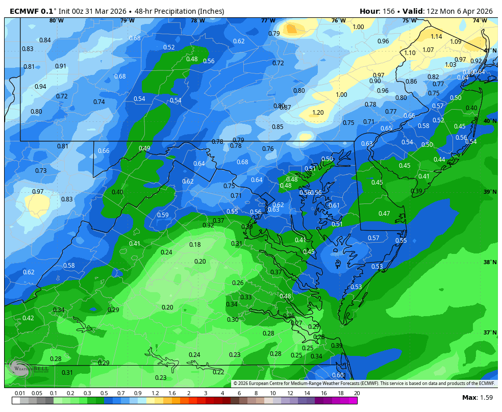
WB 0Z EURO. Wet Easter afternoon and evening. EPS supports this scenario.


- Today
-
Morning bow for Rt 2 peeps in MA?
-

2026-2027 El Nino
so_whats_happening replied to Stormchaserchuck1's topic in Weather Forecasting and Discussion
As much as I and many others would love to see the PDO actually change that ain't looking all to good right now regardless of ENSO state to come. Weak to moderate +ENSO is a solid call still with a tip to strong if it can actually get itself together. Super is a stretch but hey weird things happen. The more time passes the more I see this being situated further west with warming lets see how things shape up over the next month..thumb.gif.5958bc182277687b2cb02cca0929ae34.gif)
-
Torch !!
-

2026-2027 El Nino
PhiEaglesfan712 replied to Stormchaserchuck1's topic in Weather Forecasting and Discussion
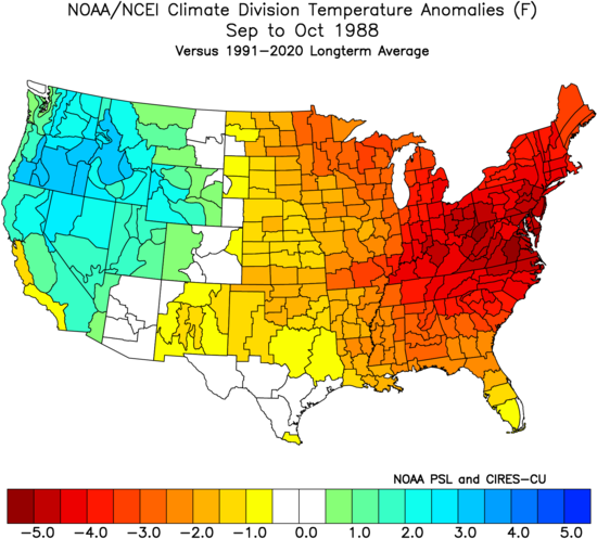
If the PDO turns positive this year, then 1988 becomes the obvious anti-2026 log. In the East, 1988 was a very warm summer, followed by a very cool fall.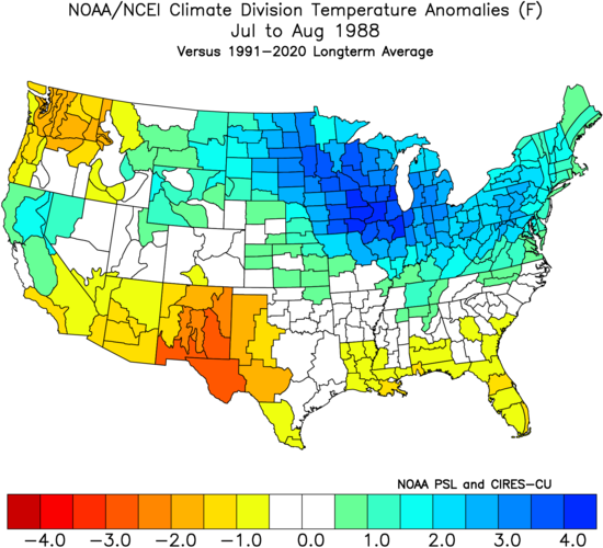
-
I agree. What happened to having spring. We haven't had spring in years. It just goes from 40 and drizzle to 85 and humid. 55 and sunny would be interesting. Sweatshirt weather doesn't exist here. Just coats to shorts.


.gif.af5e851775c897190038be95087b0545.gif)
