All Activity
- Past hour
-
Another of met summer, another month of relentless rain for 2025 (especially some days of biblical rainfall)
-

July 2025 Obs/Disco ... possible historic month for heat
CoastalWx replied to Typhoon Tip's topic in New England
Congrats Nantucket. -
Finished the month with 6.21" of rain for this June, just 0.45" away from reaching the top 10 wettest Junes on record. Top 10 Wettest Junes (DAY) 1. 10.59" - 1958 2. 9.54" - 1980 3. 9.09" - 1903 4. 7.88" - 2015 5. 7.59" - 1924 6. 7.43" - 2017 7. 7.32" - 1902 8. 7.22" - 1932 9. 7.13" - 1928 10. 6.66" - 1986
-

July 2025 Obs/Disco ... possible historic month for heat
Damage In Tolland replied to Typhoon Tip's topic in New England
Steined this morning . Winder how he’ll get us this afternoon? -
-
Loud, windy storms around 10:30-11 last night left exactly an inch. Tired of lawn mowing...as every year.
-
Updated Cansips just out, though dry for the winter, keeps it BN most areas north of the Mason-Dixon line. This is a link starting in November. Summer is reasonably tolerable over most of the conus too. https://www.tropicaltidbits.com/analysis/models/?model=cansips®ion=us&pkg=T2ma&runtime=2025070100&fh=4 500mb starting November https://www.tropicaltidbits.com/analysis/models/?model=cansips®ion=nhem&pkg=z500a&runtime=2025070100&fh=4 Enso starting November https://www.tropicaltidbits.com/analysis/models/?model=cansips®ion=global&pkg=ssta_noice&runtime=2025070100&fh=4
-
-
Updated Cansips just out, though dry for the winter, keeps it BN most areas north of the Mason-Dixon line. This is a link starting in November. Summer is reasonably tolerable over most of the conus too. https://www.tropicaltidbits.com/analysis/models/?model=cansips®ion=us&pkg=T2ma&runtime=2025070100&fh=4 500mb starting November https://www.tropicaltidbits.com/analysis/models/?model=cansips®ion=nhem&pkg=z500a&runtime=2025070100&fh=4 Enso starting November https://www.tropicaltidbits.com/analysis/models/?model=cansips®ion=global&pkg=ssta_noice&runtime=2025070100&fh=4
-
5.85 total rain for the month of June.
-
Summer 2025 Medium/Long Range Discussion
A-L-E-K replied to Chicago Storm's topic in Lakes/Ohio Valley
0z wasn't the worst in the world but definitely could use a nice wide spread MCS to soak the area instead of the spotty pop up stuff it looks we'll be getting -
Moderate risk for excessive rainfall for much of the area and slight for the rest. Expect more flood watches. https://www.wpc.ncep.noaa.gov/qpf/excessive_rainfall_outlook_ero.php eta…flood watches were already hoisted
-

July 2025 Obs/Disco ... possible historic month for heat
Lava Rock replied to Typhoon Tip's topic in New England
Lots of beer Sent from my SM-S921U using Tapatalk - Today
-

July 2025 Obs/Disco ... possible historic month for heat
Torch Tiger replied to Typhoon Tip's topic in New England
-
Hope everyone is safe and nobody gets flooded, These kind of storms are deceiving on the yearly totals. Mostly all run off
-
Hazardous Weather Outlook National Weather Service State College PA 439 AM EDT Tue Jul 1 2025 PAZ036-057-059-063>066-020845- Franklin-Dauphin-Lebanon-Cumberland-Adams-York-Lancaster- 439 AM EDT Tue Jul 1 2025 ...FLOOD WATCH IN EFFECT FROM 2 PM EDT THIS AFTERNOON THROUGH THIS EVENING... This Hazardous Weather Outlook is for central Pennsylvania. .DAY ONE...Today and tonight. Please listen to NOAA Weather Radio or go to weather.gov/StateCollege on the internet for more information about the following hazards. Flood Watch. Additionally, strong to severe thunderstorm wind gusts are possible this afternoon and early this evening. .DAYS TWO THROUGH SEVEN...Wednesday through Monday. The probability for widespread hazardous weather is low. .SPOTTER INFORMATION STATEMENT... Spotters are encouraged to report significant hazardous weather.
-
90 was the high yesterday. .49 rain yesterday.
-
I always get kind of lost looking back for the updated posts.. you might want to consider making a new post for every new data, projections and all. It's a little easier to navigate and we know when it's happening by seeing a new post in the thread. I need to come back for the rest of the year in this contest! So far I'm performing lower than I thought I should. I used to go with the least popular numbers, but the scoring isn't per place, it's only deviations from values, so it's better to not go against the grain.
-

E PA/NJ/DE Summer 2025 Obs/Discussion
Hurricane Agnes replied to Hurricane Agnes's topic in Philadelphia Region
It had been rocking and rolling with the lightning here in Philly since at least 1 am and had lots of thunder from around 2 am through about 3 am. I ended up getting an additional 0.17" yesterday on my last-reported total, for a final total of 0.63" for the day, and 3.81" for the month. And moving into the new month, the storm pretty much wound down by 4 am and I picked up 0.81" in the bucket overnight, for a 2-day total of 1.44". Currently overcast and 73 with dp 72. -
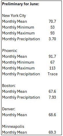
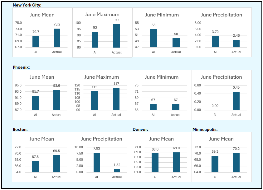
Calling all Vikings. ... Just polishing up the scoring for June and going into the update of annual scoring but I can see from how close the June scores are to each other that there cannot be huge changes in the annual contest, and basically, it's looking very competitive especially given the fact that previous years' usual leaders are a little back of the current leaders. I suspect it's going to be a fully-engaged battle for the title this year (if anyone cares about it that much).
-
4.99" yesterday + 0.21" since midnight = 5.20" for East Petersburg. Holy f-bomb Batman.
-
Bazinga!
-
Fire island reported gusts to 52.
-

E PA/NJ/DE Summer 2025 Obs/Discussion
RedSky replied to Hurricane Agnes's topic in Philadelphia Region
Chester is getting hammered


