All Activity
- Past hour
-

October Comes Early: Late September Multi-Hazard Hybrid Storm
dendrite replied to WxWatcher007's topic in New England
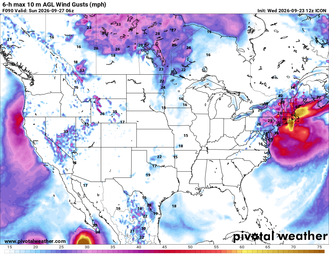
Yeah ICON is a doozy. RGEM is pretty far east, but wet enough to ruin the weekend. -
From the 11AM EDT advisory for TD 15E: ...INTERESTS IN THE HAWAIIAN ISLANDS SHOULD CLOSELY MONITOR THE PROGRESS OF THIS SYSTEM... SUMMARY OF 500 AM HST...1500 UTC...INFORMATION ---------------------------------------------- LOCATION...14.5N 154.4W ABOUT 320 MI...520 KM SSE OF SOUTH POINT HAWAII ABOUT 525 MI...840 KM SSE OF HONOLULU HAWAII MAXIMUM SUSTAINED WINDS...35 MPH...55 KM/H PRESENT MOVEMENT...WNW OR 290 DEGREES AT 6 MPH...9 KM/H MINIMUM CENTRAL PRESSURE...1004 MB...29.65 INCHES WATCHES AND WARNINGS -------------------- Interests in the Hawaiian Islands should closely monitor the progress of this system. A Hurricane or Tropical Storm Watch will likely be required for a portion of the state later today. —————————— The depression has slowed since the last advisory and seems to be moving west-northwestward at about 5 kt. A ridge to the northeast of Hawaii is forecast to weaken and slide eastward as a mid- latitude trough drops over the northwestern Hawaiian islands. This evolution is likely to the cause the cyclone to slow down later today or tonight and then turn northward or north- northeastward by tomorrow with some increase in forward speed. The trough is forecast to move westward this weekend as the ridge rebuilds north of Hawaii, which should force a sharp westward turn while the cyclone is close to the Big Island. At this time frame, it is impossible to know exactly when that turn will happen and, unsurprisingly, there is a large north-south spread in the guidance. Our best guidance is on the northern side of the track envelope, and new NHC forecast remains essentially the same as the last advisory. Interests in the Hawaiian Islands, especially on the Big Island, should closely monitor the system, with life-threatening catastrophic flooding possible over the steep terrain on this track. The depression should intensify slowly at first, given the current structure of the low-level center not co-located with the mid-level circulation as seen on satellite. However, after the system develops an inner core, the environment seems conducive for significant strengthening, with low shear, high mid-level moisture and SSTs from 28-29C. The rapid intensification probabilities are increasing, and the best model guidance is showing this as a major hurricane in a few days. Given the environment and the best-performing aids (Google DeepMind and HCCA) again showing major-hurricane strength, the NHC forecast is raised from the previous one and shows the cyclone as a major hurricane when it approaches the Big Island of Hawaii by the weekend. FORECAST POSITIONS AND MAX WINDS INIT 23/1500Z 14.5N 154.4W 30 KT 35 MPH 12H 24/0000Z 14.7N 155.2W 40 KT 45 MPH 24H 24/1200Z 15.0N 155.5W 50 KT 60 MPH 36H 25/0000Z 15.7N 155.2W 65 KT 75 MPH 48H 25/1200Z 16.7N 154.8W 80 KT 90 MPH 60H 26/0000Z 17.6N 154.5W 90 KT 105 MPH 72H 26/1200Z 18.2N 154.7W 100 KT 115 MPH 96H 27/1200Z 18.1N 157.0W 100 KT 115 MPH 120H 28/1200Z 18.7N 160.2W 95 KT 110 MPH $$ Forecaster Blake
-

October Comes Early: Late September Multi-Hazard Hybrid Storm
ineedsnow replied to WxWatcher007's topic in New England
@CoastalWx will like this run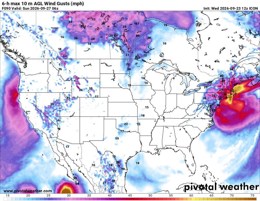
-
October Comes Early: Late September Multi-Hazard Hybrid Storm
ineedsnow replied to WxWatcher007's topic in New England
.thumb.png.50aceb0e9e202de29261f0469e0cbede.png)
-
Do you guys know there's a storm threaded for the noreaster?? Asking for a friend
-

October Comes Early: Late September Multi-Hazard Hybrid Storm
HIPPYVALLEY replied to WxWatcher007's topic in New England
Sign me up for that outcome. -
October Comes Early: Late September Multi-Hazard Hybrid Storm
ineedsnow replied to WxWatcher007's topic in New England
12z ICON and its members still pretty good.thumb.png.d119c659118bde174a704764f1fa38f4.png)
.thumb.png.2f3ed04b97ba8e69b8ad8cca14a4a07c.png)
-
October Comes Early: Late September Multi-Hazard Hybrid Storm
dendrite replied to WxWatcher007's topic in New England
It’s still coming west at 84hr, but yeah…not looking like a major impact that run. It’s better than 6z. Can’t trust the 12k nam past 6hr anyway. -

October Comes Early: Late September Multi-Hazard Hybrid Storm
weatherwiz replied to WxWatcher007's topic in New England
I think Oct. 6 unless its been pushed back again. -
58.3 here 2.82'' since late Monday,
-

October Comes Early: Late September Multi-Hazard Hybrid Storm
Brian5671 replied to WxWatcher007's topic in New England
When does it stop running? -
October Comes Early: Late September Multi-Hazard Hybrid Storm
Brian5671 replied to WxWatcher007's topic in New England
A complete miss lol -

2026-2027 Record-breaking El Nino
LakePaste25 replied to Stormchaserchuck1's topic in Weather Forecasting and Discussion
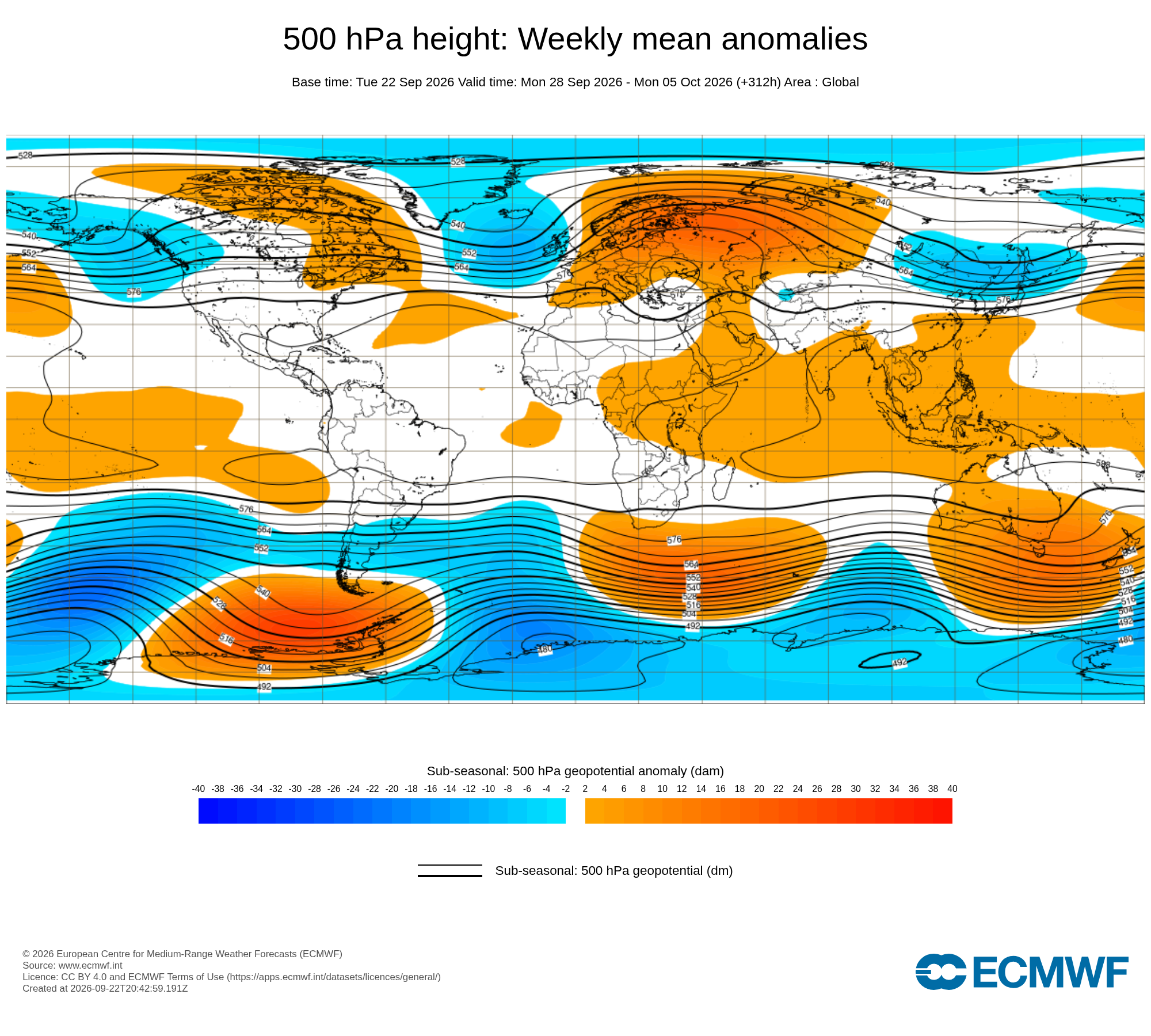
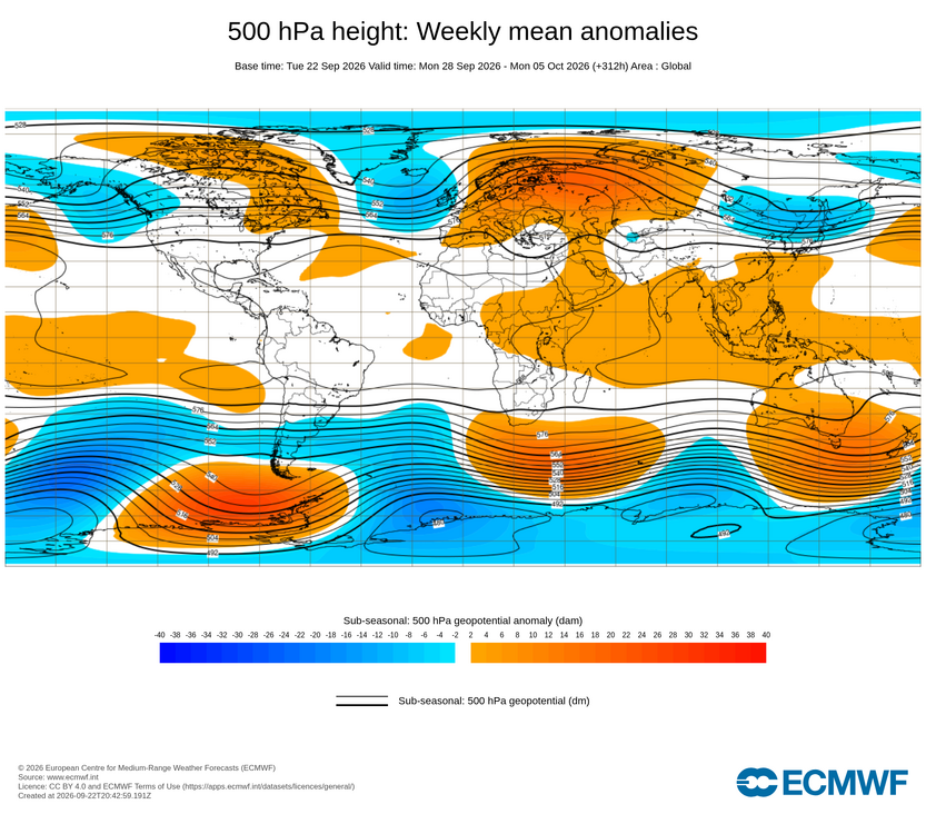
The +EPO is, but the H5 itself is not entirely cool ENSO flavored however, as the low is displaced SW will of BC into the GOA. -
October Comes Early: Late September Multi-Hazard Hybrid Storm
dendrite replied to WxWatcher007's topic in New England
50s/60s and rain? -

2026 C and E Pacific tropical activity
Boston Bulldog replied to GaWx's topic in Tropical Headquarters
Simultaneous major hurricanes named Nolo and Polo… surely the public won’t get confused lol -

2026-2027 Record-breaking El Nino
bluewave replied to Stormchaserchuck1's topic in Weather Forecasting and Discussion
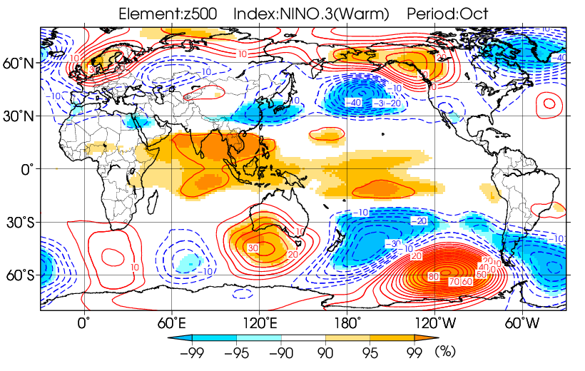
While we are still only getting a snapshot for the start of October, a +EPO is classic La Niña for October. We’ll see if heights can rebound a bit near Alaska which is more typical for El Niño. Still to early to tell where the ridge and trough locations finish for the entire month.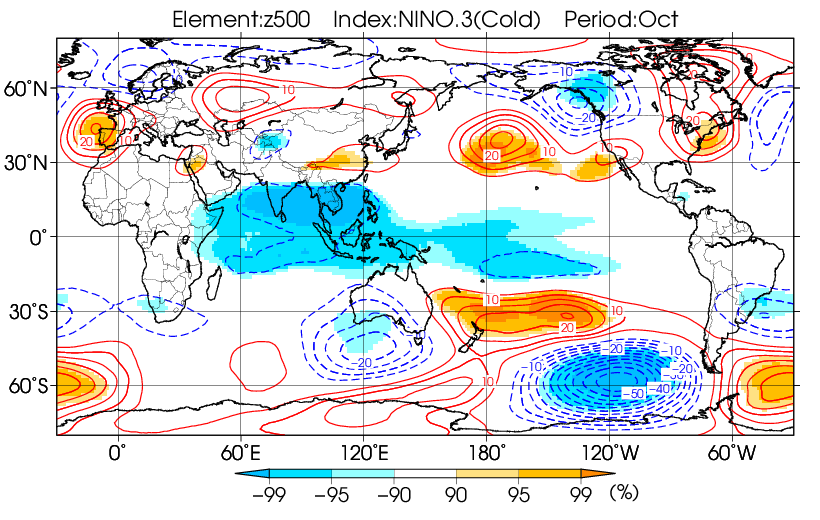
-
Septorcher 2026 Discussion - Endless Summer
weatherwiz replied to Damage In Tolland's topic in New England
Looks like Hawaii will get hit AGAIN. Rainfall forecast of 15-30"+ across the Big Island...yikes -
September 23 1995: 0.2 inches of snow falls in the St. Cloud area. 1985: Early snow falls over portions of Minnesota and western Wisconsin. Just under a half inch (0.4) is recorded at MSP Airport, mostly during the afternoon. 1937: From summer to winter. The temperature was 101 at Wheaton. Then a cold front came through causing the mercury to tumble below freezing. For Wednesday, September 23, 2026 1815 - One of the greatest hurricanes to strike New England made landfall at Long Island and crossed Massachusetts and New Hampshire. It was the worst tempest in nearly two hundred years, equal to the hurricane which struck in 1938, and one of a series of severe summer and autumn storms to affect shipping lanes that year. (David Ludlum) 1904 - The temperature at Charlotteburg, NJ, dipped to 23 degrees, the coldest reading of record for so early in the autumn for the state. (The Weather Channel) 1983 - A thunderstorm downburst caused a timber blowdown in the Kaibab National Forest north of the Grand Canyon. Two hundred acres were completely destroyed, and scattered destruction occurred across another 3300 acres. Many trees were snapped off 15 to 30 feet above ground level. (The Weather Channel) 1987 - Autumn began on a rather pleasant note for much of the nation. Showers and thunderstorms were confined to Florida and the southwestern deserts. Warm weather continued in the western U.S., and began to spread into the Great Plains Region, but even in the southwestern deserts readings remained below 100 degrees. (The National Weather Summary) 1988 - Thunderstorms developing along a cold front in the south central U.S. produced severe weather in Oklahoma during the afternoon and early evening hours. Thunderstorms produced softball size hail near Noble and Enterprise, and baseball size hail at Lequire and Kinta. A tornado near Noble OK destroyed a mobile home injuring one person. (The National Weather Summary) (Storm Data) 1989 - Seventeen cities in the north central U.S. reported record low temperatures for the date, including Devils Lake ND with a reading of 22 degrees. Jackson KY reported a record low of 41 degrees during the late afternoon. Strong northwesterly winds ushering cold air into the central and northeastern U.S. gusted to 55 mph at Indianapolis IND. Winds along the cold front gusted to 65 mph at Norfolk VA, and thunderstorms along the cold front deluged Roseland NJ with 2.25 inches of rain in one hour. The temperature at Richmond VA plunged from 84 degrees to 54 degrees in two hours. Snow and sleet was reported at Binghamton NY. (Storm Data) (The National Weather Summary) 2005 - Hurricane Rita reached the Texas/Louisiana border area near Sabine Pass as a category-3 hurricane with maximum sustained winds near 120 mph. A storm surge of at least 15 feet flooded parts of Cameron, Jefferson Davis, Terrebonne and Vermilion parishes, where sugar cane crop losses were estimated near $300 million. An 8-foot storm surge in New Orleans overtopped the provisionally-repaired levees (from Hurricane Katrina damage) and caused additional flooding. A total of 10 fatalities were reported, and preliminary damage estimates ranged between $4-5 billion. Observances: 23 Wed National Dogs in Politics Day 23 Wed Celebrate Bisexuality Day ( Bi Visibility Day) 23 Wed International Day of Sign Languages 23 Wed Education Technology Day 23 Wed National AFM Day 23 Wed National Checkers Day 23 Wed National Field Marketer’s Day 23 Wed National Great American Pot Pie Day 23 Wed National Snack Stick Day 23 Wed Restless Legs Awareness Day 23 Wed Seed Gathering Season 23 Wed Teal Talk Day 23 Wed Za’atar Day 23 Wed Go With Your Gut Day 23 Wed National Apple Cider Vinegar Day 23 Wed National Baker Day
-
Crazy given how close we are! I went back and looped the radar. It looks like a lot of it anchored in Caldwell county from 2-6 am
-
1.66” which almost 1” came down from 5:30-7:30 this morning. .
-
Huh?
-
Shocked to find 2.7 rain total. It had hardly rained last I checked about 11pm. So almost all of this total since midnight.
-
From one of the earliest, strongest PV formations to now currently forecasted to weaken, as the AO goes from positive to negative.
-

2026 Atlantic Hurricane Season
NorthHillsWx replied to Stormchaserchuck1's topic in Tropical Headquarters
Appears as if Fay has come back from the dead -
The very rough 2026 for Hawaii looks to get even rougher later this week! TD 15E had formed in the E PAC back on Sep 13th from an AEW that had moved off of Africa way back on Aug 27th. This was actually the very next wave after the one that produced Dolly in the Atlantic! This then degenerated in the E PAC into an open wave late on Sep 15th. But one week later (late last night), this reorganized back to TD 15E 405 miles SSE of Hilo, Hawaii, moving WNW. It’s forecasted to become a TS later today and then turn sharply N tonight. It is then forecasted to become a H tomorrow night and reach high end cat 2 H status Fri night while not too far S of the big island of Hawaii meaning a potential serious threat there then: From the NHC discussion: The depression is moving west-northwestward at about 10 kt on the southwest side of a low- to mid-level ridge. This ridge is expected to shift eastward and weaken while a mid- to upper-level low dives southwestward near the northwestern Hawaiian Islands. This pattern change should cause the cyclone to slow down and then turn northward or north-northeastward later this week. That motion should take the cyclone near the Big Island of Hawaii late Friday or on Saturday. Around that time, the upper low is expected to weaken and move westward, allowing mid-level ridging to become re-established to the north of the system. In response, the cyclone should turn and then accelerate westward. FORECAST POSITIONS AND MAX WINDS INIT 23/0900Z 14.0N 153.7W 30 KT 35 MPH 12H 23/1800Z 14.4N 154.7W 35 KT 40 MPH 24H 24/0600Z 14.6N 155.5W 45 KT 50 MPH 36H 24/1800Z 15.0N 155.6W 55 KT 65 MPH 48H 25/0600Z 15.9N 155.2W 70 KT 80 MPH 60H 25/1800Z 17.0N 154.9W 85 KT 100 MPH 72H 26/0600Z 17.9N 154.7W 95 KT 110 MPH 96H 27/0600Z 18.3N 156.0W 95 KT 110 MPH 120H 28/0600Z 18.2N 159.0W 95 KT 110 MPH


.png.9c965b5b49dc01900effd8af59b86e57.png)


.png.1c4d4bd04c731cdc88317567a0f06ab7.png)
.png.f812b82b515c03050056278a6cba459e.png)