
All Activity
- Past hour
-
 best mexican online pharmacy: MexiPh : mexico pharmacies
 -

Septorcher 2026 Discussion - Endless Summer
Damage In Tolland replied to Damage In Tolland's topic in New England
Could actually see that happen. We have to be paid back somehow for all the boredom and misses. The devil is in the details -

Septorcher 2026 Discussion - Endless Summer
CoastalWx replied to Damage In Tolland's topic in New England
At least summer gives some interesting weather usually. It’s been like San Diego here and I’m not holding out hopes for anything this winter that will move the weenie. I acknowledge we could get near normal snow in spots, but I’m not getting my hopes up after years of depression. Positivity is a waste. -

Central PA Summer 2026 Discussion/Obs Thread
Mount Joy Snowman replied to Voyager's topic in Upstate New York/Pennsylvania
Low of 69 with .01” of rain. One more humid day before some relief arrives. -

2026 Mid-Atlantic Severe Storm General Discussion
Eskimo Joe replied to Kmlwx's topic in Mid Atlantic
Ferry Cove mesonet site gusted to 53 mph early this morning. Impressive.- 2,527 replies
-
- 1
-

-
- severe
- thunderstorms
- (and 7 more)
-
Septorcher 2026 Discussion - Endless Summer
CoastalWx replied to Damage In Tolland's topic in New England
Only chance of an interesting fall is home brew a stuff off SE coast. -

2026 Mid-Atlantic Severe Storm General Discussion
adelphi_sky replied to Kmlwx's topic in Mid Atlantic
Yeah. I drove my kid all the way to school to see an empty parking lot. I was confused. I checked the clock twice. Asked my son did he have school today. lol. Took me about five minutes to check my email and saw the message. Weird that the whole county is out. Most of Adelphi/College Park had electricity. Even my son's school. Oh well. Perfect timing. 4 day weekend for them. -
Septorcher 2026 Discussion - Endless Summer
CoastalWx replied to Damage In Tolland's topic in New England
SVR season is in February. -
And there's something wrong with that?
-
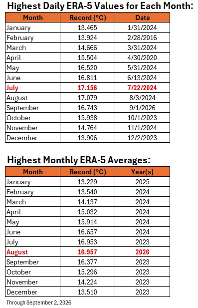
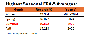
Highest daily values for each month and highest monthly and seasonal averages on ERA-5:
-
All south of me. Recorded a quarter inch of rain on the northern edge- mostly just an area of moderate rain with thunder in the distance. I'll take it. 1.5" for the week
-
Though morning AFD from LWX suggests otherwise DISCUSSION... KEY MESSAGE 1...Hot temperatures, high humidity, and severe thunderstorm chances again today into Saturday. Additional showers and thunderstorms, possibly severe, are anticipated again this afternoon/evening. Timing is a bit uncertain given the subtle waves aloft, but increasing low-level convergence paired with another upper impulse may very well result in another round or two of storms with a damaging wind risk. The latest guidance has nudged the threat a bit further north due to slower progression of the cold front, encompassing areas as far north as I- 70 or the Mason-Dixon line . While storms can develop over the region and congeal before moving southeast, areas in Ohio, Pennsylvania, and West Virginia will need to be monitored to see if anything grows upscale in those areas in linear segments and dives southeast. Highs today will range from the upper 80s to lower 90s with dew points in the lower to middle 70s resulting in heat indices in the upper 90s to lower 100s. This will be just shy of heat headline criteria (except in Charlottesville and surrounding Albemarle/Nelson Counties). The potential for early day clouds to offset heating precludes enough confidence to issue any further heat headlines at this time, though it will be unusually hot and humid for early September regardless.
-
76 this morning.
-
2026 Mid-Atlantic Severe Storm General Discussion
Eskimo Joe replied to Kmlwx's topic in Mid Atlantic
That appears to be so. We really wasted a good setup again. -
So today's final severe weather threat should be more SW of DC metro?
-

2026 Mid-Atlantic Severe Storm General Discussion
MN Transplant replied to Kmlwx's topic in Mid Atlantic
Forgot that MD is normal and has school today. By state law, VA schools are all out today. Fortuitously, given the lack of sleep many got last night. 1.46”. A lot of leaf debris but nothing significant. -
New euro doesn’t come out until 5th of each month. Tomorrow
-
PG county schools closed due to widespread power outages
-
Septorcher 2026 Discussion - Endless Summer
Damage In Tolland replied to Damage In Tolland's topic in New England
I keep thinking and wondering how or if Mother Nature is going to make it up to us. It won’t be with snow. But I could see a bunch of screaming , damaging sou’easters hitting us this fall and winter. -

Septorcher 2026 Discussion - Endless Summer
40/70 Benchmark replied to Damage In Tolland's topic in New England
I love how some resign themselves to a winter absent of snow or cold, and then throw temper tantrums when tornado alley doesn't wind a path into New England during the summer. -

2026 Mid-Atlantic Severe Storm General Discussion
biodhokie replied to Kmlwx's topic in Mid Atlantic
Didn't get the party up in Gaithersburg, pretty sure Joe and others nailed it referencing boundaries on the MD side of the Potomac. Congrats to those who finally got theirs! -
Septorcher 2026 Discussion - Endless Summer
Damage In Tolland replied to Damage In Tolland's topic in New England
At least. There were a few that were like 5 miles or less. Stafford had one , Vernon another. Mostly in Junorch and Julorch -
Take that source with a giant grain of salt....the Europeweather site views everything through snow/cold goggles.
-

Central PA Summer 2026 Discussion/Obs Thread
mahantango#1 replied to Voyager's topic in Upstate New York/Pennsylvania
WGAL News 8 Storm Team · SUMMER 2026 RECAP We still have a few weeks of Astronomical Summer left, but Meteorological Summer ended earlier this week. Here is a look at the final statistics for Summer 2026 from the Susquehanna Valley's official NWS climate site - Harrisburg International Airport (HAI). We had 3 days with highs in the 100s. The last time we had 3 days or more in the 100s during a summer season was 1999. Even though we had some incredibly hot days, we were only 0.8° above average for the whole season. This places Summer 2026 as the 15th warmest on record (out of 139 years). Summer 2026 was dry for some and wet for others in the Susquehanna Valley. At Harrisburg International Airport, it was dry with only 9.05" recorded all season. This is 3.44" below average and places Summer 2026 as the 47th driest Summer on record (out of 139 years). NOTE - some areas across the Susquehanna Valley saw very heavy rainfall due to scattered showers and thunderstorms. Due to the high variability with rainfall over short distances, the 9.05" recorded HIA may not reflect the Summer season for everyone in the Susquehanna Valley. #PAwx #WGALWeather -
From WJLA: Boy rescued after large tree crashes into Prince George's County home











