All Activity
- Past hour
-
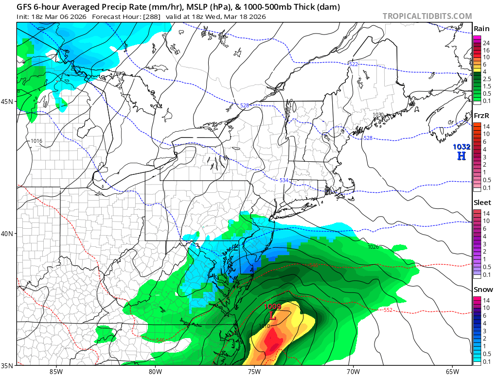
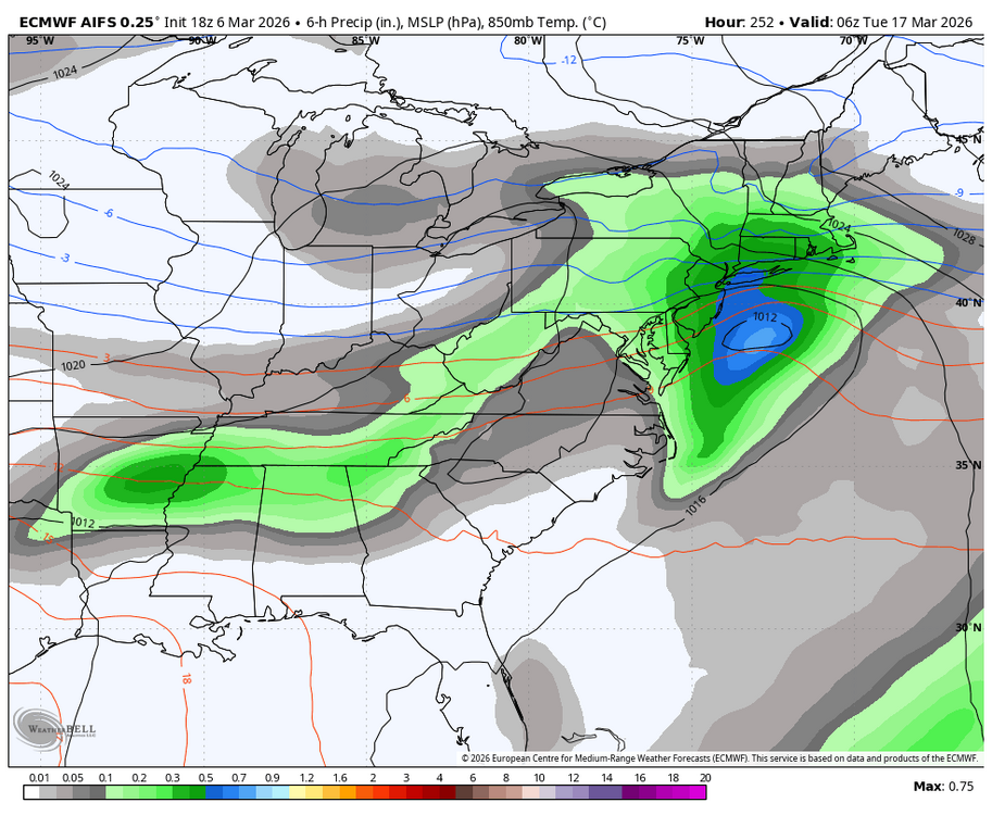
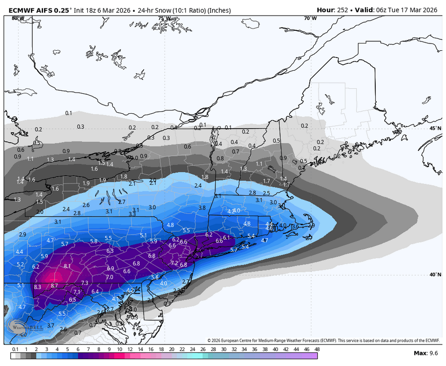
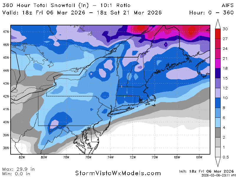
18z Euro AI delivers the Happy hour goods just in time for St. Patty’s Day!


-

Mountain West Discussion
mayjawintastawm replied to mayjawintastawm's topic in Central/Western States
I have 7.8" on my snow board now, flat sheltered area with no drifting. Wow! Still accumulating a little. We had a good 1"/hr band for from about 7:30-11:30 and steady light to moderate snow since. -
Keep denying the colder trend. This has been happening all winter. Soon or later the warmth will win out but not now.
-
we call that Seasons in Seasons.
-
Tired of my fingers and toes being chilly. I only got up to 51.
-
might see a blizzard on the 4th of July
-
1 more time Gfs also tries to spin up a coastal


-
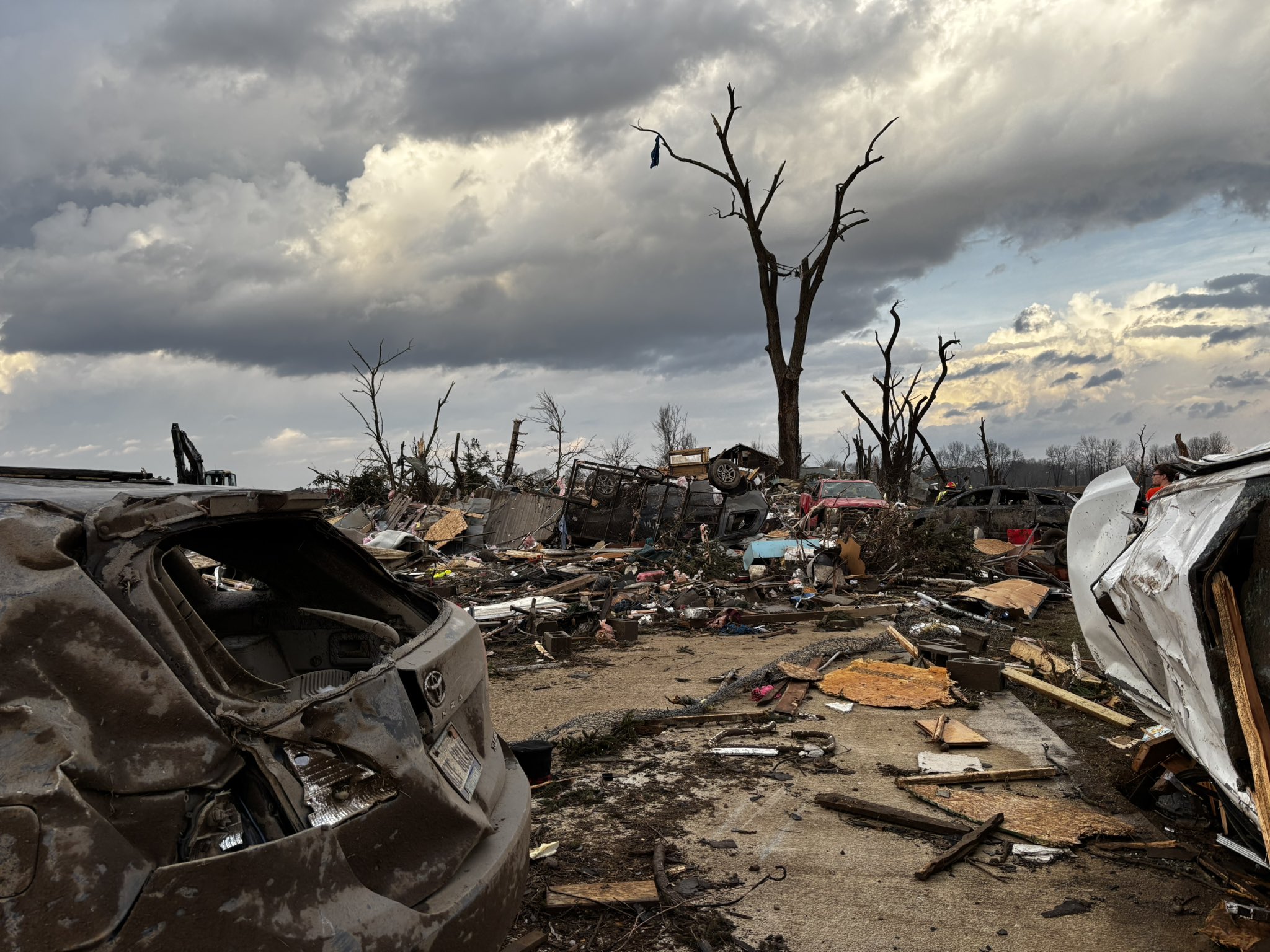
The coverage is low due to the best forcing lagging farther west (where overnight crapvection muddied things), but I feel like high end potential deserves a watch. Especially in southern Michigan where the population isn’t exactly sparse. The parameters were certainly there for a strong tornado, even if the models weren’t firing convection at that time.
-
One last chance during this timeframe and thats it.

-
April
-
Gfs is getting colder in the mid range like the Euro.
-
Today was a fluke, but it goes to show why the new SPC format is flawed trash. The science is currently not good enough and never will be good enough to set a min/max on hail size, wind speed and tor strength in outlooks and MD's.
-
Reminds me of the 2011 Tuscaloosa–Birmingham tornado or the El Reno tornado in 2013 that everyone hates talking about. Hopefully the injured recover, but my god... I hate those multi-vortex tornadoes that have those "arms." Those are some of the most violent tornadoes out there.
-

Central PA Spring 2026 Discussion/Obs Thread
Blizzard of 93 replied to Voyager's topic in Upstate New York/Pennsylvania
I’m looking forward to our 3 or 4 day warm up while actively tracking snow chances around St.Patty’s Day! I am hunting that 6.2 of snow to get MDT to climo seasonal average! -
Could be the first MI violent tornado in nearly 50 years. Tragic to say the least .
-
Make it stop
-
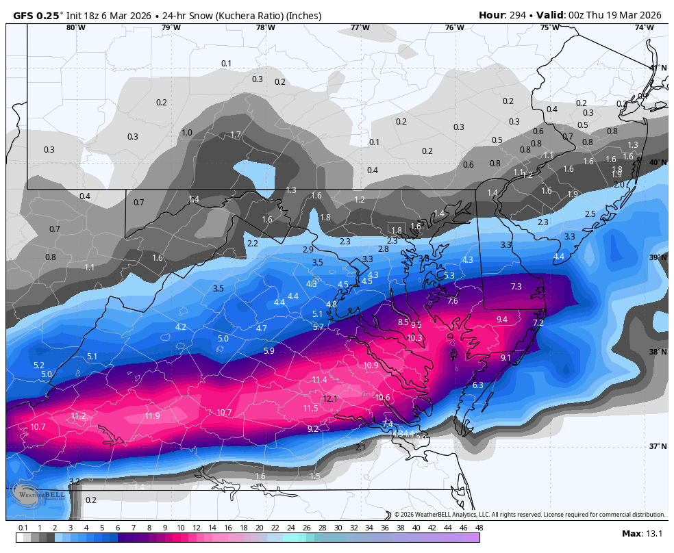
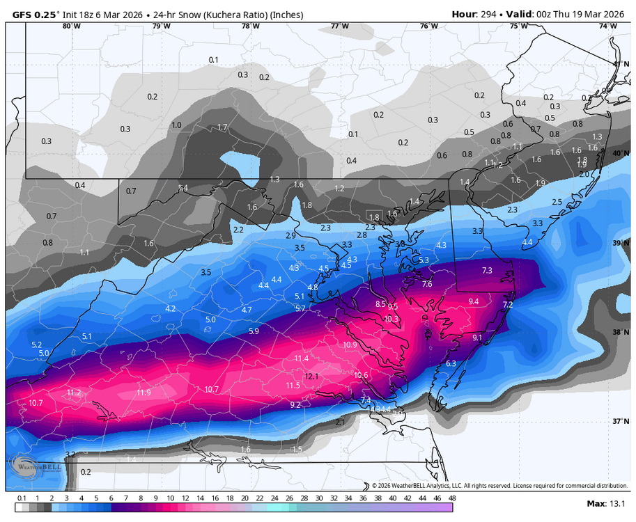
WB 18Z GFS does have fantasy storm during mid March period.
-
Yep. It all goes down the drain eventually. A lot will be gone mid week
-
Been a steady melt off here. Kind of been under the radar, but we’ve lost a lot of snow. Guessing a lot of what’s left gets vaporized next week here. Couple days of 60+ will make a big dent
-
Tough to measure this with the wind but I'm thinking 6" and maybe 7-8" considering the early melting.
-
^that's violent, to say the least.
-
First winter with DJF all below 60˚ (although barely, the pre-xmas Gricn hit 59˚ in BOS) since 2013-2014. After Feb 2015 (high of 39˚) every Feb was above 60˚ until last year (53˚) and this year (49˚). I'll take it.
-

Texas 2026 Discussion/Observations
radarman replied to Stx_Thunder's topic in Central/Western States
could be a cap bust in N TX, at least til later -
Had some decent rain come through around 4. Picked up .12”. Only the 6th of the month and have 3.81” of rain. More than I think I had all last summer.
-

2026 Severe Wx - General Thread
HillsdaleMIWeather replied to largetornado's topic in Lakes/Ohio Valley
Multiple fatalities in Union City


.thumb.png.4150b06c63a21f61052e47a612bf1818.png)