All Activity
- Past hour
-
Up to .1” now.
-
Bugs are crazy when I walk the dog, something bit me in the ass and my left cheek is itchy as hell. Thought it might be a tick but nothings there but a bite.
-
Great WAR late in the forecast period on Euro & EPS. Looks like lots of 90+ days on the way. We haven't seen this in quite a while. WX/PT
-

July 2025 Discussion-OBS - seasonable summer variability
wdrag replied to wdrag's topic in New York City Metro
Added CPC July ... issued 6/30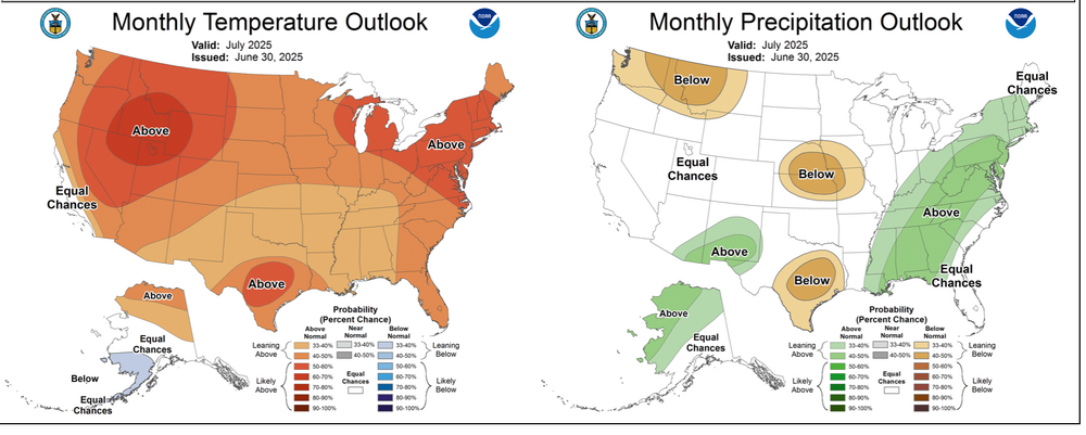
-
 Dave1215 joined the community
 -
I just noticed that the last half of June should be the warmest on record at ORD by a large margin (1°F+) and the warmest since 2012. Yuck.
-
The second half of June was phenomenal, temperature/humidity wise. T'storm/severe t'storm wise, this first half of the year has been one of the worst I can recall for action around here.
-

Central PA Summer 2025
Mount Joy Snowman replied to Voyager's topic in Upstate New York/Pennsylvania
I’m at a similar amount, probably closing in on 1.5”. Tropical in nature. Manheim area again taking it on the chin today with big totals. -
Just came to say the same thing. Up to 1.33" now. Several very close strikes. At least my power is back, at least for now.
-
Insane !
-
Complex and the tornado warning still moving NE Dangersous lightening strikes Severe Weather Statement National Weather Service Baltimore MD/Washington DC 824 PM EDT Mon Jun 30 2025 MDC025-010045- /O.CON.KLWX.TO.W.0029.000000T0000Z-250701T0045Z/ Harford MD- 824 PM EDT Mon Jun 30 2025 ...A TORNADO WARNING REMAINS IN EFFECT UNTIL 845 PM EDT FOR EAST CENTRAL HARFORD COUNTY... At 824 PM EDT, a severe thunderstorm capable of producing a tornado was located over Riverside, or near Aberdeen, moving northeast at 15 mph. HAZARD...Tornado and quarter size hail. SOURCE...Radar indicated rotation. IMPACT...For those in the direct path of a tornado touchdown, flying debris will be dangerous to those caught without shelter. Damage to roofs, siding, and windows may occur. Mobile homes may be damaged or destroyed. Tree damage is likely. This dangerous storm will be near... Aberdeen, Aberdeen Proving Ground, Riverside, and Perryman around 830 PM EDT. Other locations impacted by this tornadic thunderstorm include Harford Furnace, Abingdon, Carsins, Belcamp, and Edgewood. PRECAUTIONARY/PREPAREDNESS ACTIONS... TAKE COVER NOW! Move to a basement or an interior room on the lowest floor of a sturdy building. Avoid windows. If you are outdoors, in a mobile home, or in a vehicle, move to the closest substantial shelter and protect yourself from flying debris. Torrential rainfall is occurring with this storm, and may lead to flash flooding. Do not drive your vehicle through flooded roadways. && LAT...LON 3953 7607 3949 7611 3947 7607 3944 7605 3943 7627 3950 7634 3954 7624 3957 7612 3958 7610 TIME...MOT...LOC 0024Z 245DEG 11KT 3947 7628 TORNADO...RADAR INDICATED MAX HAIL SIZE...1.00 IN
-
say that bwe will see no more before the end of august. i dare you.
-

E PA/NJ/DE Summer 2025 Obs/Discussion
Hurricane Agnes replied to Hurricane Agnes's topic in Philadelphia Region
My round 1 ended up being the 0.44" but then I had a mini round 2 that gave me a couple hundredths more so currently have 0.46" in the bucket. Looks like a round 3 is incoming in the next hour or two if it holds together. Have been checking out the TORs that keep popping up down in MD north of Baltimore. Currently overcast and 77 with dp 77. -
What is Peter Pann even talking about?
-
ORD hit 90° on Saturday, 94° on Sunday, and 90° today. Midway wasn't even close on Saturday (Lake Breeze), but hit 93° on Sunday and 91° today. ...2025 90°+ Day Tally... 12 - DPA 11 - ORD 10 - MDW 10 - RFD 10 - ARR 10 - PWK 10 - LOT 7 - UGN
-
I got on radarscope and zoomed in as close as I could into that storm and I still counted nearly 100 lightning strikes on the map with most spots within 500ft of a recent CG.
- 1,234 replies
-
- 1
-

-
- severe
- thunderstorms
- (and 2 more)
-
It's not bad. The cool nights I don't care for. warm nights, 70's at night 90's day is perfect.
-
Central PA Summer 2025
Mount Joy Snowman replied to Voyager's topic in Upstate New York/Pennsylvania
These storms are relentless. Just keep reforming. -

E PA/NJ/DE Summer 2025 Obs/Discussion
Kevin Reilly replied to Hurricane Agnes's topic in Philadelphia Region
Light Rain 77f humidity 96% dew point 76f Total Rainfall today so far 0.02" -
Both my father and f-I-L have told me the bel air storm is the most intense lightning storm they can remember
- 1,234 replies
-
- 1
-
-
- severe
- thunderstorms
- (and 2 more)
-
Mega humid here. DP reached 82 but has now plummeted to only 80 so I pushed the lawnmower. Very sweaty endeavor but at least was mostly shaded by this time. 89 for our high today. Current 85/80
-
Humidity here wasn’t bad. Def not hazy. And 83.5 wasn’t really hot. very enjoyable. Wish it was warmer.
-
Drizzle. What looked very promising just completely dried up. I'm trying to understand what was over nenj/nyc are to cause it to literally evaporate?
-
Will that line of storms make it here this time or will it dry up too over LI?
- Yesterday
-

E PA/NJ/DE Summer 2025 Obs/Discussion
RedSky replied to Hurricane Agnes's topic in Philadelphia Region
Round one only a graze. Round two looks weak.


