All Activity
- Past hour
-

E PA/NJ/DE Winter 2025-26 Obs/Discussion
PhiEaglesfan712 replied to LVblizzard's topic in Philadelphia Region
It seems like all the la nina/-ENSO years that end in 5 or 0 are cold in December. See 1995, 2000, 2005, and 2010. The only one one that wasn't cold was 2020, and we got a snowstorm mid-month. -
It drives me nuts but not nearly as bad as seeing it snow weekly in the winter 20 miles from my house as the crow flies while I bask in the sun
-

December 14th - Snow showers or Plowable snow?
CoastalWx replied to Sey-Mour Snow's topic in New England
That will come soon -

December 14th - Snow showers or Plowable snow?
SouthCoastMA replied to Sey-Mour Snow's topic in New England
Definitely more staying power on mid-Cape based on the trajectory. almost done with here. You should get 2"+ with this. I'll have to measure in a bit when I get a chance -
Thanks, Mitch. For the MidAtlantic, I roughly estimate 55% AN vs 45% BN. So, quite mixed as you’re implying. Thus, the predictability for Christmas and other days nearby is pretty low.
-
Lol right! Freeze your nickers off!
-
Sound effect snow showers on the south fork of Suffolk now. Rare to see
-

2025-2026 Fall/Winter Mountain Thread
Buckethead replied to Buckethead's topic in Southeastern States
Except for going out to measure the snow this morning, I haven't been outside. I see no reason to start now lol. Sent from my SM-S908U using Tapatalk -
You going to take a midnight stroll lol.
-

December 14th - Snow showers or Plowable snow?
Diggiebot replied to Sey-Mour Snow's topic in New England
Very windy and low visibility. Def hitting now -
2025-2026 Fall/Winter Mountain Thread
Buckethead replied to Buckethead's topic in Southeastern States
1° with a 44mph gust just now. That puts the windchill at -28°. Sent from my SM-S908U using Tapatalk -
I wonder how he’ll respond if the warm up getting walked back materializes?
-
December 14th - Snow showers or Plowable snow?
CoastalWx replied to Sey-Mour Snow's topic in New England
Deep winter on the cape now -

Central PA Winter 25/26 Discussion and Obs
canderson replied to MAG5035's topic in Upstate New York/Pennsylvania
I’ll buy you a beer anytime! I’ll still drink out and about occasionally, but had to kinda do a hard reset lol -

Central PA Winter 25/26 Discussion and Obs
anotherman replied to MAG5035's topic in Upstate New York/Pennsylvania
No room for stuff like this. Needs to be cleaned up. There’s a ton of garbage on social media and it makes message boards like this more desirable. This is supposed to be a place where you don’t have to wade through the crap to talk about what you love. -

Central PA Winter 25/26 Discussion and Obs
pasnownut replied to MAG5035's topic in Upstate New York/Pennsylvania
Thank goodness its cold outside. Everyone go step outside for 5 minute minimum, then come back in w/ cooler heads. and frostbite on your pekrs. -
Central PA Winter 25/26 Discussion and Obs
anotherman replied to MAG5035's topic in Upstate New York/Pennsylvania
What in the world is going on in here? -
December 14th - Snow showers or Plowable snow?
CoastalWx replied to Sey-Mour Snow's topic in New England
Yeah, got me nesr 2 inches. I’m happy. -
18° at 6pm steady fall all day.
-
3 degrees. Cold AF
-
December 14th - Snow showers or Plowable snow?
Diggiebot replied to Sey-Mour Snow's topic in New England
Smoked good for you south coast -
long island won today
-
Following the season's first appreciable snowfall, tomorrow will be blustery and cold. High temperatures will likely wind up below 30° in much of the region. Morning lows could challenge the coldest so far this season. The WPO has reached severely negative levels. That will likely contribute to the December 10-20 period being colder than normal overall. Moderation is possible late in the period as the WPO begins to rise. However, with the EPO forecast to go negative, exceptional warmth is unlikely. The probability that December 2025 will have a maximum monthly temperature below 60° is increasing. The last time that happened was in 2019 when the monthly high was 58°. If 2025 has a monthly high below 60°, that would be only the fifth such occurrence since 2000 (2003, 2004, 2005, and 2019 are the cases since 2000). The ENSO Region 1+2 anomaly was -0.2°C and the Region 3.4 anomaly was -0.5°C for the week centered around December 3. For the past six weeks, the ENSO Region 1+2 anomaly has averaged -0.27°C and the ENSO Region 3.4 anomaly has averaged -0.65°C. La Niña conditions will likely continue through at least mid-winter. The SOI was +9.50 today. The preliminary Arctic Oscillation (AO) was +1.900 today. Based on sensitivity analysis applied to the latest guidance, there is an implied near 95% probability that New York City will have a cooler than normal December (1991-2020 normal). December will likely finish with a mean temperature near 34.5° (4.6° below normal). Supplemental Information: The projected mean would be 2.9° below the 1981-2010 normal monthly value.
-

December 14th - Snow showers or Plowable snow?
Ginx snewx replied to Sey-Mour Snow's topic in New England
Hmm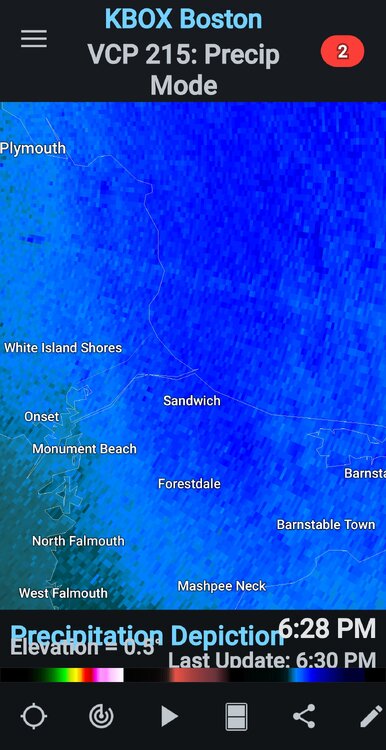
-
December 14th - Snow showers or Plowable snow?
Diggiebot replied to Sey-Mour Snow's topic in New England
Nice band in interior Plymouth county raynham Bridgewater


