All Activity
- Past hour
-
Why I truly hate Manhattan…you are so out of touch with the natural world. Its awful. But I know thats why people love it.
-

December 2025 regional war/obs/disco thread
SouthCoastMA replied to Torch Tiger's topic in New England
A lot of it is hyperbole in good fun. Sure some of it is over the top but who cares. When a storm is imminent we will all unite, I think -

December 2025 regional war/obs/disco thread
Typhoon Tip replied to Torch Tiger's topic in New England
So I guess the gripe is centered around losing the white Xmas ? as far as the 'scalar' value of the Euro run ( anyway ) I thought that was entertaining enough. Xmas itself on that run has a wall of snow with probably impact visibility and road deterioration as a strong WAA burst throws a quick 3" followed by some IP/zr... It cuts off, then there's a Schwegler wrap for some mood stuff lingering into Boxing morning. It's a winter storm man. Then there's a NJ modeler for 3-5" three days later... It's D10 so ... yeah, probably won't be there on the next cycle lol. but it's not exactly a winterless run -

December 2025 Short/Medium Range Forecast Thread
Daniel Boone replied to John1122's topic in Tennessee Valley
Yeah, eastern areas may very well not see much of the warm-ups at all. I think, as you alluded to earlier as well, we get in on some of them until Blocking asserts. I'm betting we see a couple very warm Days (60's) with maybe 70's western area's. I made a comment over in the MA Sub how we could get around the NPAC GOA Low problems as they're down on that being there as many are. Blocking is the key .Secondly, MJO in cold Phases . Also, gave you a Shout-out about your Pac NW Feedback Idea and how it could very well be the Case. If Jeffs still viewing, what's your take on what Carver's Ideas are irt the Feedback possibility of the Model's in the Pac NW ? -
I get it, not good to be all negative all the time, but people hate when negative things are posted. That’s not even a debate.
-
Cold grey wintery day in NYC.
-
Picked up another .1" from this morning's clipper. Visibility was below 1/2 mile briefly. Over 8" on the season. We have surpassed the entire 2023-24 winter!
-

December 2025 regional war/obs/disco thread
WinterWolf replied to Torch Tiger's topic in New England
Sure…but That was never the point to any of this, and I think you know that. the Mild rain at the end of the week..that’s all good…let’s wash up the road and get the chemicals off. -
hopefully your weather predictions are as good as your grammatical skills
-

E PA/NJ/DE Winter 2025-26 Obs/Discussion
Birds~69 replied to LVblizzard's topic in Philadelphia Region
Looks like a line forming to our West. Probably catastrophic...tundra like 25F currently/overcast.
-
yeah that's super common out that way. Drive from C'ville to Crozet even. You see it in the valley a lot - Between about Winchester and southern Augusta County, you are slowly increasing in elevation. Sometimes you have rain turning to snow as you drive south.
-
I will be right, about this
-
But we can close the shades for a week or so.
-
Just glad my wind sensor broke few of the ice last night eventually
-
Wonder if any of our board members near the park are willing to make “alternative” measurements for future snowfalls. I think someone has in the past.
-
You have posted this atleast 3 times already, we heard you the first 2 times.
-
I did notice that on the EPS. Its still steps away from a winter storm pattern but it could trend toward a CAD threat pattern.
-

-

Mid to long range discussion- 2025
WinstonSalemArlington replied to wncsnow's topic in Southeastern States
-
https://x.com/bam_weather/status/2000645576275231015?s=46&t=j_-aw-4tjFwrt5AoXKNk5A The Bam view is clear
-
It was just nice to finally see a widespread 4-8” clipper which used to be very common in the old days. I wonder if we can find a way to sneak in a KU that rapidly deepens near the benchmark with some portion of the area going 12” before the end of the season? My guess is that we will probably need at least one of these events for most spots from Newark out across Long Island to make it to closer to the long term average in the mid 20s for snowfall. It would be nice to finally see a bounce back year after the repeated lower totals last 7 years and lack of KU events. I have been looking at the La Niña December snowfall in more detail last few days to try to find where a cutoff may be for average to above average snowfall. Previously used a 4” snowfall total for a rough approximation of a cutoff. Correcting for the Central Park under measurement they should be right at 4” and Newark is 4.2”. But all of the average to above snowfall seasons had 7.7”+in December like 2020, 2017, 2010, 2008, 2005, 2000, and 1995. The one exception was 2016. So it’s possible that the actual cutoff could be in the 4-7”range. It will be interesting to see how things work out the rest of the season. I am posting the Newark data below instead of NYC since they have a paid contract observer there. Even adding a bit to the NYC totals getting them closer to Newark shows the same relationship. 15 most recent La Niña Decembers using RONI and Total Seasonal Snowfall at Newark 24-25….3.5”…..13.6” 22-23….0.1”……2.7” 21-22….0.1”……17.9” 20-21…..11.9”…45.7” 17-18…….7.7”….39.4” 16-17……3.4”….30.0”…..The one year the relationship didn’t work out 11-12……0.0…..8.8” 10-11…..24.5”…68.2” 08-09….8.3”….27.1” 07-08….3.9”….14.6” 05-06….11.0”….37.9” 00-01….14.9”….39.3” 99-00……T…….18.4” 98-99….1.2”…..12.8” 95-96….12.8”….78.4”
-

-
It was just nice to finally see a widespread 4-8” clipper which used to be very common in the old days. I wonder if we can find a way to sneak in a KU that rapidly deepens near the benchmark with some portion of the area going 12” before the end of the season? My guess is that we will probably need at least one of these events for most spots from Newark out across Long Island to make it to closer to the long term average in the mid 20s for snowfall. It would be nice to finally see a bounce back year after the repeated lower totals last 7 years and lack of KU events. I have been looking at the La Niña December snowfall in more detail last few days to try to find where a cutoff may be for average to above average snowfall. Previously used a 4” snowfall total for a rough approximation of a cutoff. Correcting for the Central Park under measurement they should be right at 4” and Newark is 4.2”. But all of the average to above snowfall seasons had 7.7”+in December like 2020, 2017, 2010, 2008, 2005, 2000, and 1995. The one exception was 2016. So it’s possible that the actual cutoff could be in the 4-7”range. It will be interesting to see how things work out the rest of the season. I am posting the Newark data below instead of NYC since they have a paid contract observer there. Even adding a bit to the NYC totals getting them closer to Newark shows the same relationship. 15 most recent La Niña Decembers using RONI and Total Seasonal Snowfall at Newark 24-25….3.5”…..13.6” 22-23….0.1”……2.7” 21-22….0.1”……17.9” 20-21…..11.9”…45.7” 17-18…….7.7”….39.4” 16-17……3.4”….30.0”…..The one year the relationship didn’t work out 11-12……0.0…..8.8” 10-11…..24.5”…68.2” 08-09….8.3”….27.1” 07-08….3.9”….14.6” 05-06….11.0”….37.9” 00-01….14.9”….39.3” 99-00……T…….18.4” 98-99….1.2”…..12.8” 95-96….12.8”….78.4”
-
reminds me of how before I left Cville you could see snow on the tops of the mountains all around town but there was nothing on the ground at all in the university itself.
-
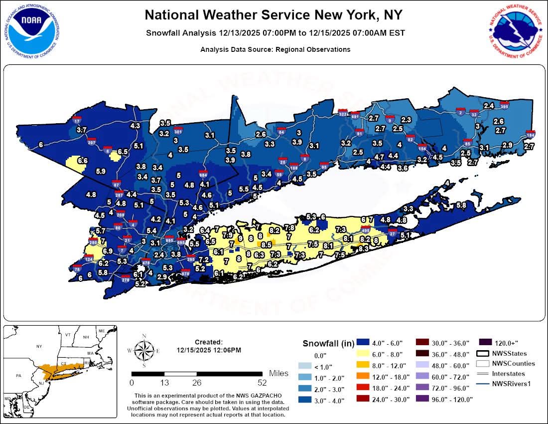
Something should be done and should've been done for years. Have a dedicated NWS observer there who will measure properly or take the obs someplace else. I can understand parts of the city having less because they struggled with temps for a while but that's just ludicrous how on TV there was clearly 3" with snow still coming down at a good clip and temps falling. JFK right on Jamaica Bay struggled with temps too and came in with 4.6". I showed pics of my neighborhood to a relative in FL yesterday and they were stunned about how much fell where I am vs "I heard the city only had 2". It's ridiculous.