All Activity
- Past hour
-
Agree... You can't be blamed for being gun shy... Lots of screw jobs over the past few years. That being said, I think optimism is warranted... Since we will be dealing with mainly SWFEs, it would be nice to get some secondary, even weak, lows running out under SNE? I am certainly going to stay conservative, especially SOP, in the short term. Would love to see the pattern morp into one favoring coastal as we move into the heart of the winter; very late Dec onward. For now, Midwest track favored with SWFE causing our main action... Missing out on early December snows doesn't really bother me; I'm just looking for favorable pattern trends. Liking fact 40/70 is bullish in general.
-
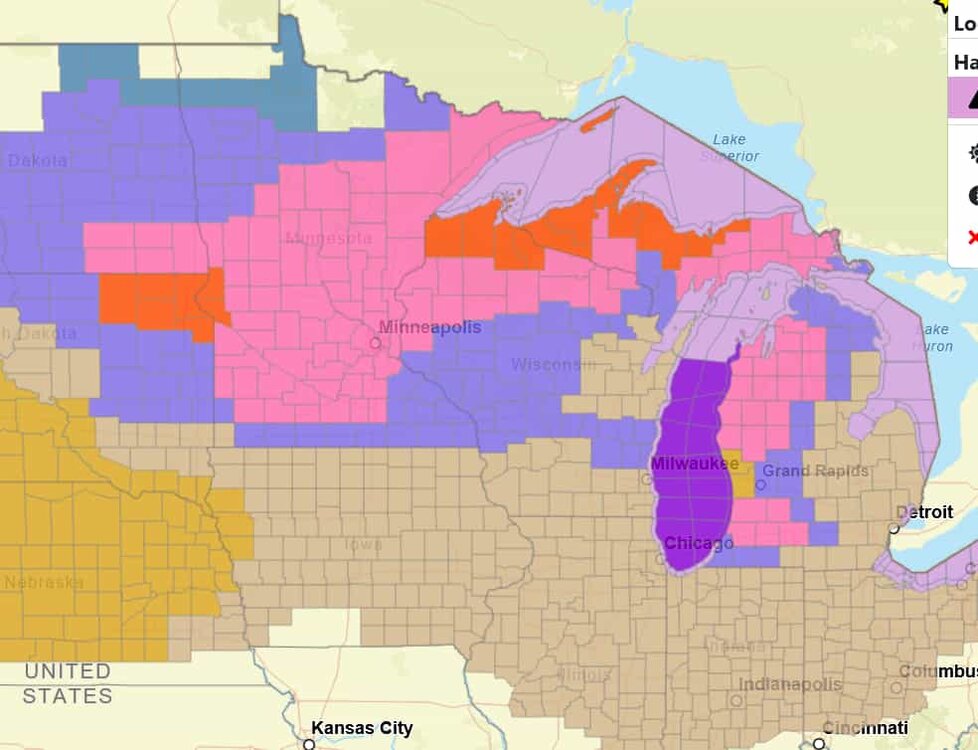
Good to see some colors back on the map
-
LES bands starting form. Getting some snow right now. Little earlier than expected, so possible 6"+ in town is possible.
-
Next Tuesday is looking tantalizingly close.
-
Yes his is stellar. My records started in 1966 and really got going 1980-present . What happened from April into Setptember and what’s been happening last 15 or so days, each with a weighted average. When I find , for example, that May and June with near historically wet then July with very high heat indexes then August dry and normal temps and Nov 1-15 damp dreary snd chilly-what followed all that? When I can find 4 out of 5 matches or 7 out of 10 then I reveal my thoughts I like 12/4-5
-
I haven't received any measurable rain yet. That 3-5" snow here would have required a vivid imagination!
-

December 2025 regional war/obs/disco thread
SouthCoastMA replied to Torch Tiger's topic in New England
8 years since the last above average season here. 1 Average season and 6 below average since. so sick of this sh*t..I'll take average or slightly above at this point -
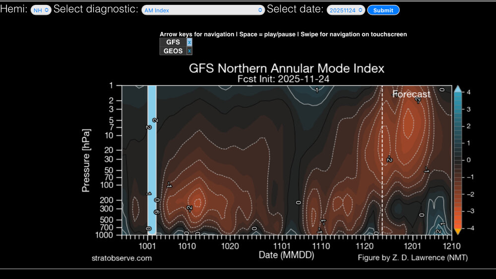
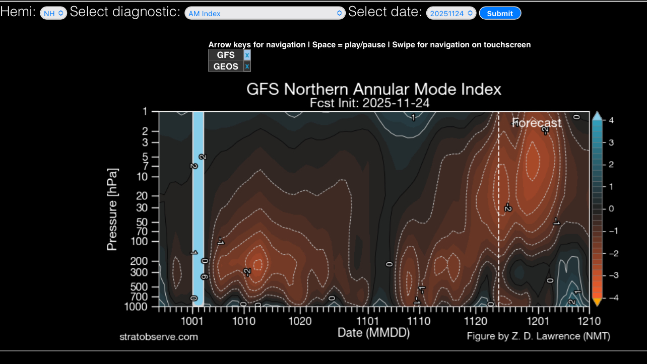
The effects of the SSW look to completely decouple from the surface (for now).
-
This would have been another easy 3-5” snow. Getting precip cored rn. Raw day.
-
That’s how I feel. I’m optimistic, but I can’t help but to always look to see what can go wrong. It’s probably some PTSD lol, but it’s been the reality last few years. 2025 has been the most challenging for me. I could use a good winter stretch.
-
I hope you have fun with your crowd! I just got back a few weeks ago from looking around the Keewenaw and it's absolutely killing me to miss the blizzard knocking on their doors. Any other time, I'd be on my way there. Crossing my fingers you have enough to play with . I'll wave from Richmond lol.
-
Wow, Pacific pattern is completely different.
-
That's going to be the issue as this pattern unfolds during December. Degree of old loading into southeast Canada will be critical. Too much assist from -NAO and we get suppression; too little and SNE gets screwed by warming, but ice potential increases? But if we get modest confluence locked in by weak to moderate -NAO and it could be a solid December; especially NOP! I would keep expectations low right now, but it's an active look with decent potential.
-

2025-2026 ENSO
Daniel Boone replied to 40/70 Benchmark's topic in Weather Forecasting and Discussion
Yeah, the reflection thing is a concerning Factor for sure. As mentioned earlier, it will make for an interesting forecast period with the MJO in cold Phases. -
Ray's Winter Storm Archive, while focused primarily on New Jersey, is an excellent resource for winter storms during the 1993 - 2013 time frame.
-
God I booked the wrong year for a rockies early Jan ski trip. On the other hand when they torch we get snow.
- Today
-
3/4 days ago I responded to Ji that I was excited about 12/4-5. That comes from my memory and records of analog past events
-

Nov 28-30th Post Turkey Day Wintry Potential
ILSNOW replied to Chicago Storm's topic in Lakes/Ohio Valley
Chicago NWS Attention then turns toward the next storm system due to arrive in our region this weekend. Ensemble model guidance remains in agreement that an upper-level wave currently halfway between the states of Hawaii and Washington will come ashore and propagate eastward across the contiguous US on Friday and into the Mississippi River Valley on Saturday. As the wave approaches, it may attempt to phase with subtle preceding shortwaves emanating from the remnants of the subtropical jet along the US/Mexico border and a polar wave dropping south out of Canada. The degree of interaction with any of these waves will ultimately influence the eventual evolution of the storm system, which is leading to the usual spread of ensemble outcomes typical for a system 4 days out. Generally speaking, the expectation is for a region of warm- air advection snow to develop across the region early Saturday morning and then to transition to "cold conveyer belt" frontogenesis-driven snow Saturday into Saturday night. Depending on the exact evolution and strength of the system, a warm nose may surge into parts of the area leading to a transition from snow to rain at some point on Saturday. Regardless, the ensemble signal, particularly among the EPS suite, remains strong for our general region to experience impactful snow on Saturday. -
 Snow showers/ squalls around on Friday as folks cut their Xmas trees down
 -
But the MJO is forecast to spend 7 to 10 days in phase 8. Im not sure if its going to be warm mid month. I can see a slight warmup but nothing lasting
-
The data seems to show though that this SSW event is a combined reflective-absorptive sudden stratospheric warming event. The reflection phase allows for the Alaskan Ridge and a positive AO and positive NAO in the near term. Absorbing Phase: Subsequently, the stratosphere switches to an absorbing state, where it absorbs the upward wave energy, leading to a breakdown or weakening of the polar vortex. This absorption phase causes downward propagation of anomalous winds and is typically associated with a negative phase of the AO/NAM, leading to an increased likelihood of cold air outbreaks in mid-latitudes, particularly across North America and Eurasia. Tropospheric Impacts The distinct phases of a combined event lead to a sequence of different weather impacts on the Earth's surface: Near-term (Reflective Phase): Stronger westerlies and an active storm track across northern Europe may be observed, with temporary ridging in the North Pacific. Medium-term (Absorptive Phase): Increased pattern uncertainty emerges as the vortex breaks down, typically leading to the negative AO pattern and potential severe winter cold in mid-latitude regions. From Met Jens Bonewitz Stratospheric Update: hashtag#Potential Combined Reflective-Absorptive hashtag#SSW Developing! Following yesterday's discussion (link: https://lnkd.in/egEFCFuq), models continue to indicate persistent hashtag#wave-1 forcing on the stratospheric polar vortex (SPV) extending into December—this time driven primarily by an intensifying hashtag#Aleutian Low. We may be witnessing a combined or consecutive reflective-absorptive hashtag#SSW event. As discussed in the recent hashtag#Hannachi et al. (2025) paper, these complex events occur when upward propagating planetary waves first reflect off the disturbed vortex (creating negative heat fluxes that temporarily strengthen the SPV and accelerate the polar jet), before subsequently being absorbed, leading to vortex breakdown and downward wave activity flux propagation to the troposphere. Expected hashtag#Tropospheric Response: Near-term (into early hashtag#December): hashtag#Pacific: Temporary Alaskan Ridge (AkR) development; N Atlantic: Positive AO/NAO as reflected waves accelerate the jet stream—stronger westerlies and active storm track across northern EuropMedium-term (mid-late December): Increasing pattern uncertainty as absorption phase dominates. Downward coupling from the disturbed SPV likely triggers AO/NAO trend reversal. Enhanced (negative) blocking potential across Atlantic-European sector. Key hashtag#Uncertainty: The timing and magnitude of stratosphere-troposphere coupling in consecutive wave forcing events remains highly non-linear. While the ~60-day lag framework provides guidance, the volatile nature of this setup challenges deterministic forecasts beyond 2-3 weeks. hashtag#Graphics (attached): Time-height evolution of max.wave-1 height amplitude showing sustained and intense forcing in the upper and into the middle stratosphere (1-10 hPa) from late November through early December; source, incl.latest hashtag#forecast: https://lnkd.in/esD7gEtP. The persistent high-amplitude wave activity (>1500-1900 gpdm in the upper stratosphere) represents the continuous pressure on the polar vortex—key driver for the potential reflective-absorptive hashtag#SSW sequence. Additional Context: 500 hPa hashtag#GFS forecast (30 Nov) showing the main tropospheric driver: intense hashtag#Aleutian Low. Note the deep low pressure system over the North Pacific providing upward wave forcing into the stratosphere. Additional diagnostics: https://lnkd.in/eM2nHteb https://lnkd.in/eXr7cGtG
-

2025-2026 ENSO
TheClimateChanger replied to 40/70 Benchmark's topic in Weather Forecasting and Discussion
How's the weather looking in Ann Arbor on Saturday? Hearing rumors of snow for The Game? -
So DCA would be 20 at 1 am
-
Amen and I have been getting crucified for years for saying this. It’s good to have a more popular poster finally get on board Lets go over the needed changes. Nothing beyond 5 days out. Drop the microscope approach and do a broader naked eye or binoculars approach stop trying to find out why the last forecast needs changing ingest more AI analog historical outcomes accept the FACT that 50 different outcomes is Not a forecast nor prediction but rather a needless cover all bases conglomeration There are mire but until and unless the consumers of models stop paying for and extolling the virtue of failing models then nothing will change
-
Can see on the 12z EPS what a little bit more ridging does into nrn Greenland. Keeps the confluence going in SE Canada. I’d like to see that going forward.

.thumb.jpg.ad3a2e31d30aff035044689b311a0540.jpg)


.thumb.JPG.418e8a9a2902ae687ec35ff4bc0e038e.JPG)


