All Activity
- Past hour
-
Pretty big frost and 35 at the house
-
April 21 1910: A snowstorm hits northeastern Minnesota. Duluth picks up 6.5 inches. For Tuesday, April 21, 2026 1958 - Portions of Montana were in the midst of a spring snow burst. Snowfall amounts ranged up to 55 inches at Red Lodge, 61 inches at Nye Mine, and 72 inches at Mystic Lake. (David Ludlum) 1967 - Severe thunderstorms spawned 48 tornadoes in the Upper Midwest. Hardest hit was northern Illinois where sixteen tornadoes touched down during the afternoon and evening hours causing fifty million dollars damage. On that Friday afternoon tornadoes struck Belvidere IL, and the Chicago suburb of Oak Lawn, killing 57 persons. (David Ludlum) 1980 - The temperature at International Falls MN hit 90 degrees. (The National Weather Summary) 1987 - Unseasonably warm weather prevailed from the Gulf of Mexico to New England and the Great Lakes Region, with twenty-nine cities reporting record high temperatures for the date. Afternoon highs of 82 degrees at Caribou ME, 94 degrees at Mobile AL, 95 degrees at Monroe LA, and 93 degrees at New Orleans LA, were records for the month of April. (The National Weather Summary) 1988 - After having had just twelve rainouts in the previous twenty-six years at Dodger Stadium, a third day of heavy rain in southern California rained out a double-header at Dodger Stadium which had been scheduled due to rainouts the previous two days. (The National Weather Summary) (Storm Data) 1989 - The temperature at Las Animas, CO, soared to 100 degrees to establish a state record for April. Twenty-two cities in the central and southwestern U.S. reported record high temperatures for the date. Eight cities equaled or exceeded previous April records. (The Weather Channel) (The National Weather Summary) 1990 - Afternoon and evening thunderstorms produced golf ball size hail in Oklahoma, and also caused some flash flooding in the state. Thunderstorms over the Southern High Plains produced golf ball size hail at Roswell NM and El Paso TX. Easterly winds and temperatures near zero produced wind chill readings as cold as 50 degrees below zero for the spring festival (Piuraagiaqta) outdoor events at Barrow AK. (The National Weather Summary) (Storm Data) 2007 - The South Plains and Panhandle of West Texas were hit by an outbreak of severe thunderstorms. Between the hours of 5 and 6 pm, several thunderstorms developed across the western South Plains. Around 7 pm, a supercell produced a tornado which touched down around Fieldton (southwest of Olton) and then moved just south and east of Olton, doing damage to several structures and equipment. The thunderstorm continued to move northeast across northeast Lamb, northwest Hale, southeast Castro and southwest Swisher Counties, producing a long-lived tornado (along with hail up to the size of tennis balls). By 7:45 pm, the storm approached the town of Tulia in Swisher County. A tornado touchdown was reported in the town, causing major damage. The tornadic thunderstorm continued to move northeast across Swisher County over open country through about 8:30 pm. (NWS Lubbock, TX)
-
We've actually lucked out somewhat-a fair amount of sunny days (Even if chilly) this spring and last week was a bonus.
-
Whoa our Xfinity service down in southern Calvert has been down since 8:30 last night. Says “network damage” which doesn’t sound good! Got down to 34° with some frost and now up to 47°. Waiting for 50° to put the plants back out
-
That commercial came to mind
-
Stations around my neighborhood ended up in the upper 20s mostly.
-
Even July 4 weekends. I remember a few years ago it rained that whole weekend and didn’t get out of the 50s. Usually Memorial Day is around when we stop getting hit with the nasty backdoor fronts.
-
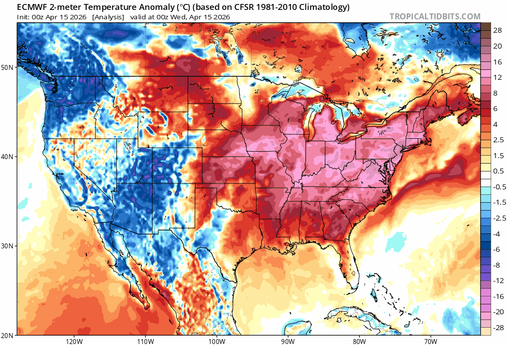
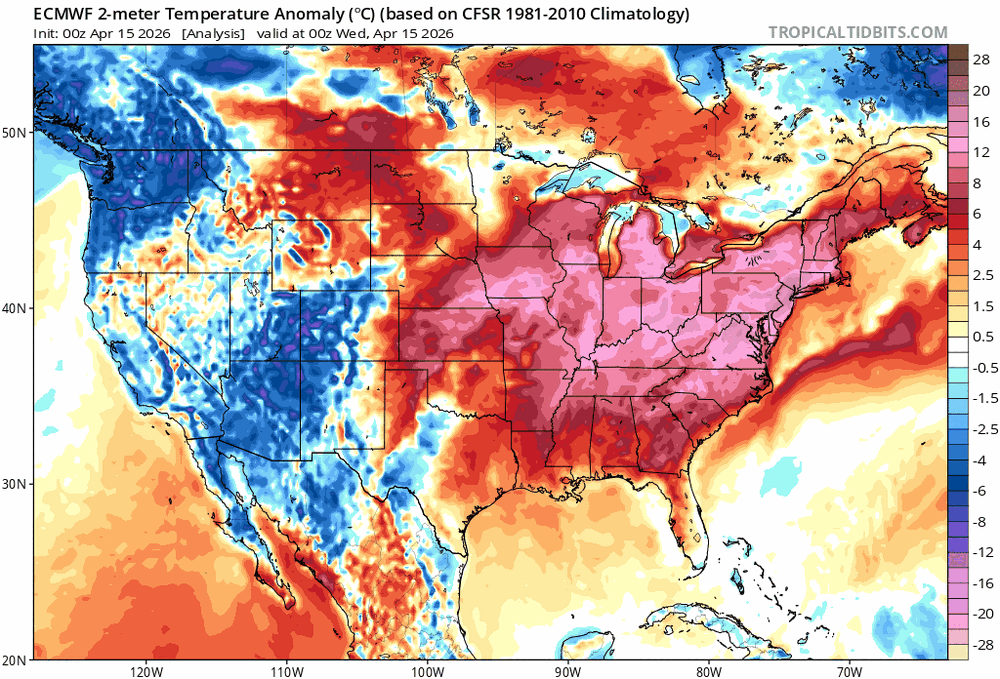
Yeah ... in so far as this, I was not intending to argue that. Ha. No I'm just changing the subject a bit that we've appeared to slip back into this bias of cooler loading into SE Canada and NE/CONUS, not dissimilar to what plagued the the winter months. I provided those monthly means ( C/O NASA) around the 10th of every succeeding new month over winter and into early spring. Every month with the possible exception of March ( though arguable...), demoed we were cooler, either relative to local climatology when not relative to the planet as a whole. That annoys me, full disclosure. For a couple of reasons. One being that I was afraid of a spring that forcibly jams cold shit down our throats and being powerless to stop it haha. I'm grappling with how much of this is "normal" though to be fair. The other reason is that CC-sociological stuff... which is a murky imperfect science of human oblivion that I'll leave alone for now. I've shown no pause or shyness in extolling my extra special hatred for April over the years, despite my love for "springing" away from winter - but therein is the problem. Seldom does this geography experience that kind of transition. I am definitely done with winter ( usually...) by February 15th every year, so let's big brother seasonal change while mother nature's not looking! Anyway, looking forward at guidance for the next ...actually out to the end of the 360s, if that really characterizes our verification we will likely be back in that cold bias region..
-
(002).thumb.png.6e3d9d46bca5fe41aab7a74871dd8af8.png) To state it better - The above chart Charlie highlights shows that NCEI has met their objective of taking out actual raw station data to alter the data to hide the cyclical pattern in the raw data. Of course, if you leave in all the station changes you won't match the revised/altered NCEI or any other "scientific" analysis. The above thread and data produced by chescowx consistently uses certified NWS actual data and ensures it is not influenced by bad analysis or exhibits any of the clear confirmation bias that underscores the altered data often used to support climate alarmism.
To state it better - The above chart Charlie highlights shows that NCEI has met their objective of taking out actual raw station data to alter the data to hide the cyclical pattern in the raw data. Of course, if you leave in all the station changes you won't match the revised/altered NCEI or any other "scientific" analysis. The above thread and data produced by chescowx consistently uses certified NWS actual data and ensures it is not influenced by bad analysis or exhibits any of the clear confirmation bias that underscores the altered data often used to support climate alarmism. -
People forget that spring sucks here. Always has and always will. Anything before Memorial Day is a crap shoot. We’ve had shitty Junes before where we couldn’t hit 80.
-
30 here this morning.
-

2026-2027 El Nino
LakePaste25 replied to Stormchaserchuck1's topic in Weather Forecasting and Discussion
If it is not going to snow in December then I hope we get a December 2015 type outcome so I can enjoy the nice weather outdoors. December 2023 was not ideal, because it was still hostile for snow but it was in the 30s most days. -
Central PA Spring 2026 Discussion/Obs Thread
ChescoWx replied to Voyager's topic in Upstate New York/Pennsylvania
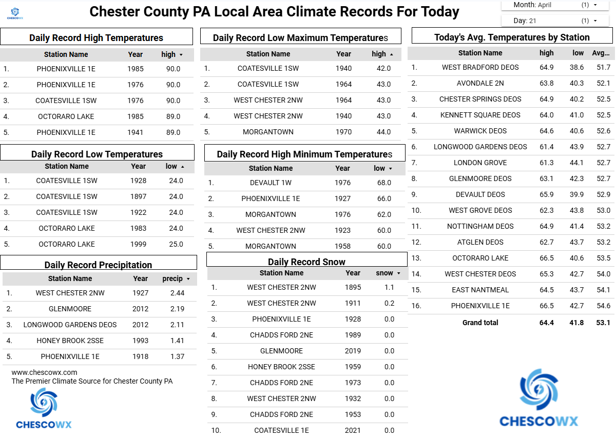
We had a widespread hard freeze (sub 28 degree) this morning with the latest sub-30-degree temperature I have ever recorded (records back to 2004) here in East Nantmeal with a low of 27.4. In looking back at records for the higher elevation spots (+600 ft ASL) of Chester County this appears to be the latest reading in the 20's in 37 years since the 27-degree reading at Coatesville 2W on April 24, 1989. Both KMQS Coatesville Airport and the Longwood Gardens DEOS station with 18 years of records also recorded their latest sub 30 degree reading this morning. In addition, many of our shorter-term stations with 15 years of records also set a record for latest hard freeze including DEOS stations in Atglen, Devault, Glenmoore, Kennett Square, Warwick, West Chester and West Grove. We stay unseasonable chilly through tomorrow with highs by tomorrow warming to near 60 degrees. We should see above normal temperatures by Thursday before we fall back below normal for the weekend. We have some light shower chances tomorrow morning with a better chance at more significant rains by Saturday.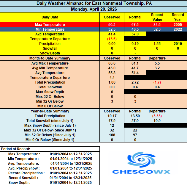

-
E PA/NJ/DE Spring 2026 Obs/Discussion
ChescoWx replied to PhiEaglesfan712's topic in Philadelphia Region
We had a widespread hard freeze (sub 28 degree) this morning with the latest sub-30-degree temperature I have ever recorded (records back to 2004) here in East Nantmeal with a low of 27.4. In looking back at records for the higher elevation spots (+600 ft ASL) of Chester County this appears to be the latest reading in the 20's in 37 years since the 27-degree reading at Coatesville 2W on April 24, 1989. Both KMQS Coatesville Airport and the Longwood Gardens DEOS station with 18 years of records also recorded their latest sub 30 degree reading this morning. In addition, many of our shorter-term stations with 15 years of records also set a record for latest hard freeze including DEOS stations in Atglen, Devault, Glenmoore, Kennett Square, Warwick, West Chester and West Grove. We stay unseasonable chilly through tomorrow with highs by tomorrow warming to near 60 degrees. We should see above normal temperatures by Thursday before we fall back below normal for the weekend. We have some light shower chances tomorrow morning with a better chance at more significant rains by Saturday.
-
E PA/NJ/DE Spring 2026 Obs/Discussion
ChescoWx replied to PhiEaglesfan712's topic in Philadelphia Region
Ugh! we missed out here in Chesco! So we will close our 2025-26 winter season with 15 winter events!! Actually Birds I am more efficient than you surmised with the entire Chester County data set on 2 cloud servers and an external drive. Spreadsheet wise - even more efficient with only 1 source excel spreadsheet mirrored on Google Sheets for analytics run off of Data Studio (a great analytics program by the way!) -
Ouch and double ouch! Got down to 27.2 here. Currently 38.9/22.1 at 9:20 am. EDIT- on a side note, see that Canaan NWR got down to 8.6 overnight!
-
Nothing is going on…welcome to spring… in SNE anyway…I don’t think we have to worry about 50 degree days in July in the mid Atlantic or SNE.
-
Yup…55-60 with the sun out bright with light wind is fine this time of year.
-
34 in lynbrook so avoided a freeze. KFOK 22 which is ridiculous for late April. .
-
-
There was widespread 10s in the northern plains. My point though is that everyone got a piece of this. Maybe we linger some slightly BN temps into the weekend with chilly mins, but we’ll still have some napey 60° afternoons.
-
Yeah, I was 91.2 a few days ago and last night 23.9.
-
Impressive airmass and even more so after a week of 80-90 degrees
- 754 replies
-
- 1
-

-
- april showers bring may..
- rain
- (and 2 more)
-
Thanks Colonel Kurtz from a philly board for these stats, impressive! Both obviously record lows. 27 degrees at TTN is the coldest this late in the season on record, previous latest 27 degrees was 4/20/1926, AVE date of the last 27 degree day is 3/25 24 degrees at ABE is also the coldest this late in the season on record, previous latest 24 degrees was 4/16/1943, AVE date of the last 24 degree day is 3/26
- 754 replies
-
- 2
-

-
- april showers bring may..
- rain
- (and 2 more)
-
Low of 24, was below freezing from 10:45pm to 8:10am, a solid hard freeze, pun intended.