All Activity
- Past hour
-
Looks great 7/3 - 7/6 7/3: Warm/ 80s - low 90s 7/4 : dry - gorgeous NW flow - 80s 7/5 : Warm 80s- low 90s (stray hot spots) 7/6 : Hot/Humid 90s
-
I need rain bad as I've missed out for several days now. That FF watch jinx makes me nervous A sweaty 78/78 to start
-

July 2025 Obs/Disco ... possible historic month for heat
CoastalWx replied to Typhoon Tip's topic in New England
Looks like clouds screw up today -
More top 10 monthly warmth around the area. Islip and Sussex, NJ recorded their warmest Junes on record. Since the new 1991-2020 climate normals are so warm, all it took was a +3.2 at Islip and +3.4 at Sussex. Time Series Summary for SUSSEX AIRPORT, NJ - Month of Jun Click column heading to sort ascending, click again to sort descending. 1 2025 71.1 0 2 2024 71.0 0 - 2005 71.0 0 3 2021 70.1 0 4 2008 69.7 0 5 2014 69.6 0 6 2010 69.2 0 7 2020 68.8 0 8 2007 68.3 2 9 2001 68.2 0 10 2011 68.1 0 Time Series Summary for SOMERSET AIRPORT, NJ - Month of Jun Click column heading to sort ascending, click again to sort descending. 1 2024 72.4 0 2 2005 72.3 0 3 2010 71.9 0 4 2025 71.7 0 - 2008 71.7 0 5 2021 71.5 0 6 2020 70.5 0 7 2015 70.3 4 - 2013 70.3 0 - 2001 70.3 0 8 2014 70.2 0 - 2011 70.2 0 9 2016 70.1 0 10 2006 70.0 0 Time Series Summary for NEWARK LIBERTY INTL AP, NJ - Month of Jun Click column heading to sort ascending, click again to sort descending. 1 1994 77.8 0 2 2024 77.5 0 3 2021 76.2 0 - 2010 76.2 0 4 1993 75.8 0 5 2025 75.4 0 - 1943 75.4 0 6 2008 75.3 0 7 1984 75.0 0 8 1971 74.8 0 9 2005 74.6 0 - 1981 74.6 0 - 1973 74.6 0 10 2011 74.5 0 Time Series Summary for JFK INTERNATIONAL AIRPORT, NY - Month of Jun Click column heading to sort ascending, click again to sort descending. 1 2010 74.5 0 2 1984 73.9 0 3 2024 73.8 0 4 2008 73.4 0 5 2025 72.9 0 6 2001 72.5 0 7 1991 72.3 0 8 1952 72.2 0 9 2011 72.1 0 - 1971 72.1 0 10 1994 72.0 0 Time Series Summary for WESTCHESTER CO AP, NY - Month of Jun Click column heading to sort ascending, click again to sort descending. 1 2024 71.9 0 2 2025 71.5 0 3 2010 71.4 1 4 1999 71.3 1 - 1957 71.3 0 5 2005 70.9 2 6 2008 70.8 0 7 1952 70.7 0 8 1994 70.6 0 9 2021 70.5 0 - 1991 70.5 2 10 1949 70.4 1 Time Series Summary for ISLIP-LI MACARTHUR AP, NY - Month of Jun Click column heading to sort ascending, click again to sort descending. 1 2025 72.2 0 2 2024 72.0 0 3 2010 71.9 0 - 1999 71.9 0 4 2008 71.6 0 5 1994 71.3 0 6 2001 70.9 0 7 2020 70.7 0 8 2021 70.6 0 9 2014 70.5 0 - 1991 70.5 0 10 1984 70.1 0
-

July 2025 Discussion-OBS - seasonable summer variability
SACRUS replied to wdrag's topic in New York City Metro
74 / 73 clouds and some breaks. Breaks of sun heats up quickly, where its clear long enough it gets to 90s, otherwise 80s / humid with storms in the PM and overnight. Wed more of the same but could be mainly cloudy. Thu clears out mid 80 - low 90s in the hotter spots. Gorgeous 4th of July, sunny, drier, 80s for most. Saturday turning more humid. Sun (7/6) into early next week turns hotter/humid. Ridge building west with pieces of heat coming east and the W. Atl ridge expanding west towards the coast looking overall warm - hot and humid / wetter. 7/1 - 7/2 : Warm-hot / humid storms , clouds- storms focus Tue PM - Overnight 7/3 - 7/5 : Dry/ warm - Fourth is a gorgeous day. Isolated storm (wed PM) 7/6 - 7/9: Hot/humid 90s - storms isolated mainly 7/10 - beyond - overall warm - hot / humid wetter -
 We can't seem to get a good thunderstorm when we want one so having one at 1am when no one wants it and also wakes everyone up will have to do
 -

July 2025 Discussion-OBS - seasonable summer variability
steve392 replied to wdrag's topic in New York City Metro
Had some heavy rains overnight. Currently 73 and just crazy humid out. -

2025 Spring/Summer Mountain Thread
Met1985 replied to Maggie Valley Steve's topic in Southeastern States
Looks like it's going to be a stormy day today then we get some heat then another cold front. -

Central PA Summer 2025
Mount Joy Snowman replied to Voyager's topic in Upstate New York/Pennsylvania
Low of 70 and 4.07” of rain here. Honestly, I was expecting more but the late night stuff didn’t quite perform the way the earlier stuff did. Still, has to be one of my highest one-day totals on record, will check the spreadsheet later. Not loving the look for later today. We could really use a break over this way. -

July 2025 Obs/Disco ... possible historic month for heat
512high replied to Typhoon Tip's topic in New England
Happy July warm weather crew! 73/70 heavy clouds -
 Violent thunder woke me up around 1am. Is fire island ok?
 -
-
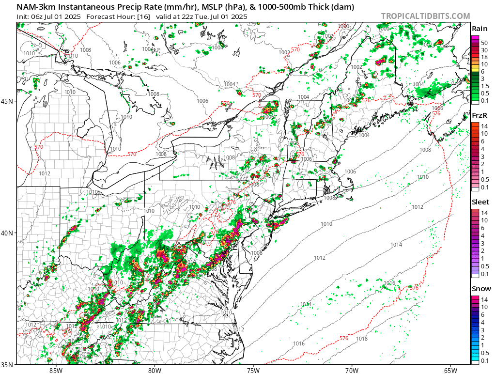
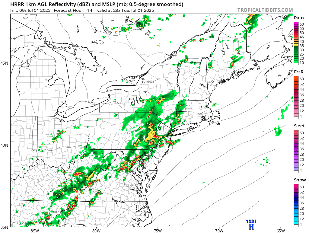
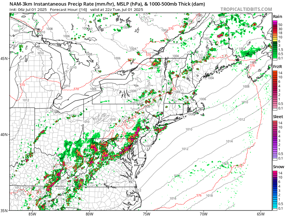
 Dissapointing die off near I80 overnight, after 2+ near Trenton and apparently 1-1.5 parts of southeast LI earlier today. This afternoon-night should be active with mesoscale SVR/FF reports. Leftover rain Wed morning LI-NJ. I probably wont be back on til late today.
 -
3K and HRRR showing an active afternoon into evening.

-

Summer 2025 Medium/Long Range Discussion
Spartman replied to Chicago Storm's topic in Lakes/Ohio Valley
https://x.com/WxRiskGrains/status/1939524075975581933 -

July 2025 Obs/Disco ... possible historic month for heat
Chrisrotary12 replied to Typhoon Tip's topic in New England
Can’t get thunderstorms over land anymore.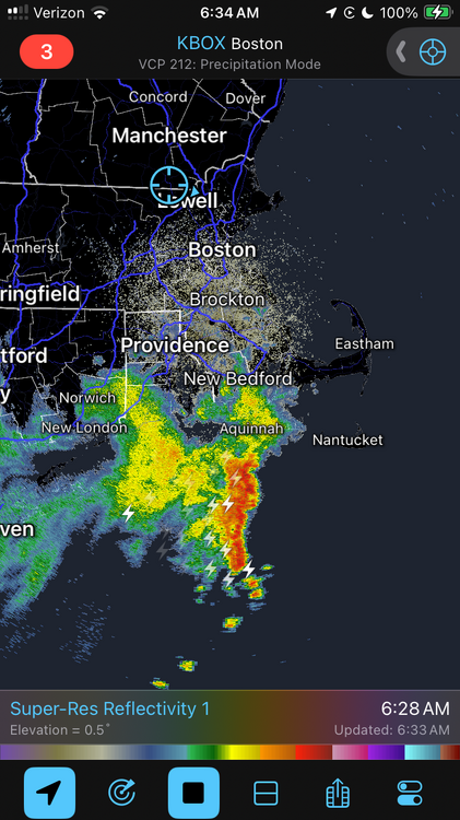
-
Another of meteorological summer, another month of relentless rain for 2025 (especially some days of biblical rainfall)
- Today
-
78/75
-
July 2025 Obs/Disco ... possible historic month for heat
CoastalWx replied to Typhoon Tip's topic in New England
Congrats Nantucket. -
Finished the month with 6.21" of rain for this June, just 0.45" away from reaching the top 10 wettest Junes on record. Top 10 Wettest Junes (DAY) 1. 10.59" - 1958 2. 9.54" - 1980 3. 9.09" - 1903 4. 7.88" - 2015 5. 7.59" - 1924 6. 7.43" - 2017 7. 7.32" - 1902 8. 7.22" - 1932 9. 7.13" - 1928 10. 6.66" - 1986
-

July 2025 Obs/Disco ... possible historic month for heat
Damage In Tolland replied to Typhoon Tip's topic in New England
Steined this morning . Wonder how he’ll get us this afternoon? -
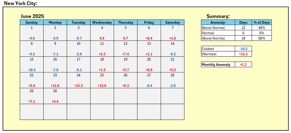
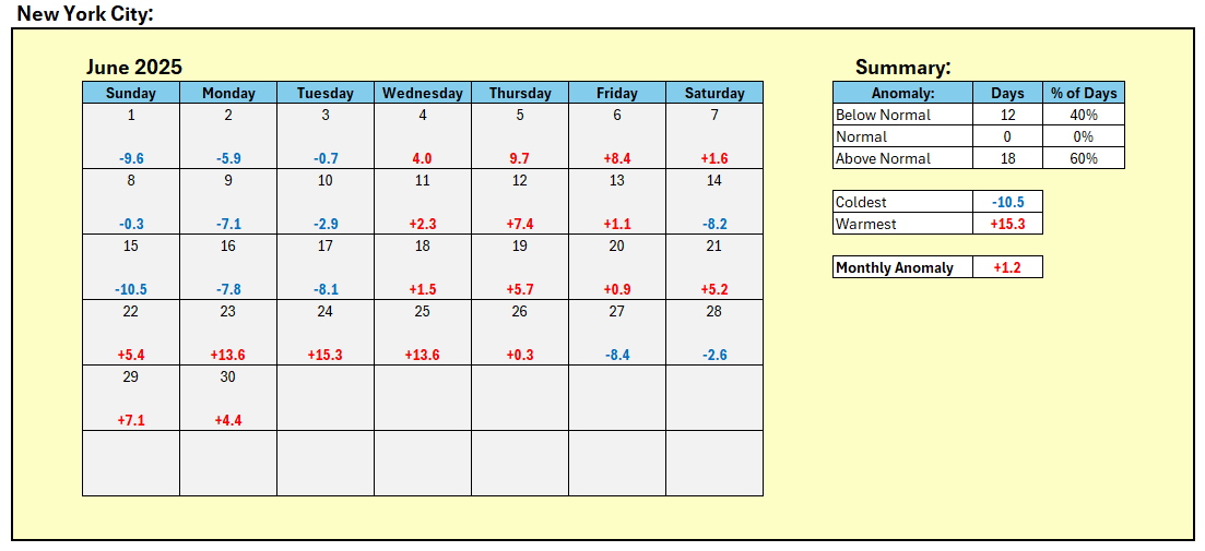
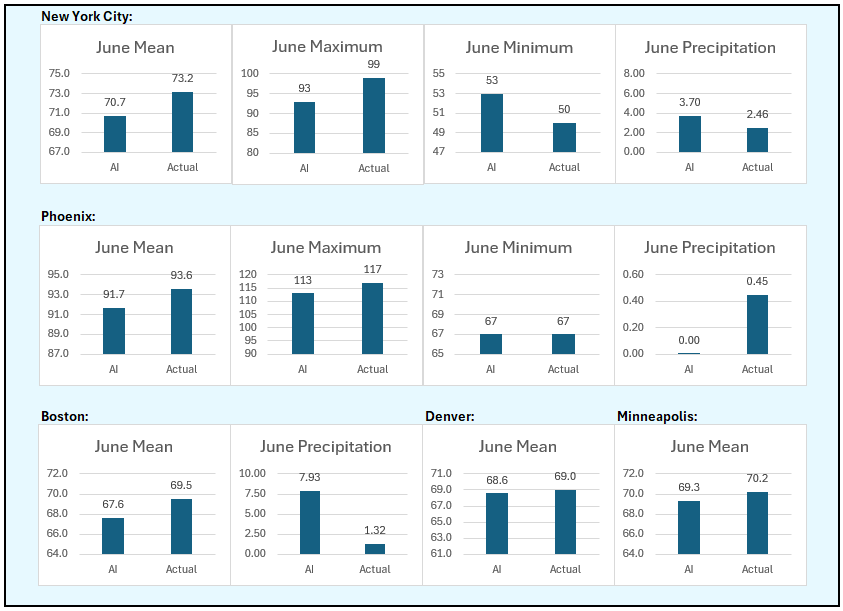
June Verification:
-
Loud, windy storms around 10:30-11 last night left exactly an inch. Tired of lawn mowing...as every year.
-
Updated Cansips just out, though dry for the winter, keeps it BN most areas north of the Mason-Dixon line. This is a link starting in November. Summer is reasonably tolerable over most of the conus too. https://www.tropicaltidbits.com/analysis/models/?model=cansips®ion=us&pkg=T2ma&runtime=2025070100&fh=4 500mb starting November https://www.tropicaltidbits.com/analysis/models/?model=cansips®ion=nhem&pkg=z500a&runtime=2025070100&fh=4 Enso starting November https://www.tropicaltidbits.com/analysis/models/?model=cansips®ion=global&pkg=ssta_noice&runtime=2025070100&fh=4
-
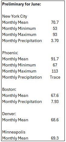
Final June numbers: